Ruatoria (Māori: Ruatōria) is a town in the Waiapu Valley of the Gisborne Region in the northeastern corner of New Zealand's North Island.[4][5] The town was originally known as Cross Roads then Manutahi and was later named Ruatorea in 1913, after the Māori Master female grower Tōrea who had some of the finest storage pits in her Iwi at the time (Te-Rua-a-Tōrea).[4] In 1925 the name was altered to "Ruatoria",[4] although some texts retain the original spelling.[6][7][8]
Ruatoria's Whakarua Park is the home of the East Coast Rugby Football Union.[9]
^Cite error: The named reference Area was invoked but never defined (see the help page).
^ abBE45 - Waipiro Bay (Ruatoria) (Map). 1:50,000. Topo50. Land Information New Zealand. Retrieved 12 May 2012.
^"Subnational population estimates (RC, SA2), by age and sex, at 30 June 1996-2023 (2023 boundaries)". Statistics New Zealand. Retrieved 25 October 2023. (regional councils); "Subnational population estimates (TA, SA2), by age and sex, at 30 June 1996-2023 (2023 boundaries)". Statistics New Zealand. Retrieved 25 October 2023. (territorial authorities); "Subnational population estimates (urban rural), by age and sex, at 30 June 1996-2023 (2023 boundaries)". Statistics New Zealand. Retrieved 25 October 2023. (urban areas)
^ abcSoutar, Monty (23 August 2011). "East Coast places - Waiapu River valley". Te Ara - the Encyclopedia of New Zealand. Wellington, New Zealand: Manatū Taonga | Ministry for Culture and Heritage. Retrieved 12 May 2012.
^"Our District". Your Council. Gisborne, New Zealand: Gisborne District Council. 19 April 2010. Retrieved 12 May 2012.
^Harmsworth, Garth; Warmenhoven, Tui Aroha (2002). "The Waiapu project: Maori community goals for enhancing ecosystem health" (PDF). Hamilton, New Zealand: New Zealand Association of Resource Management. Retrieved 3 January 2021.
^"The Rise and Rise of Umuariki" (PDF). Te Nupepa O te Taiawhiti. Gisborne, New Zealand: Gisborne Herald: 19. Retrieved 12 May 2012.
^"Pukemaire and Reporua" (PDF). Te Ao Maori O te Tairawhiti. Gisborne, New Zealand: Gisborne Herald: 26. 7 September 2007. Retrieved 12 May 2012.
^"The Union". Ruatoria, New Zealand: East Coast Rugby Football Union. Retrieved 12 May 2012. We are located on the East Coast of the North Island, based in Ruatoria.
Ruatoria (Māori: Ruatōria) is a town in the Waiapu Valley of the Gisborne Region in the northeastern corner of New Zealand's North Island. The town was...
Rugby Union. It is located on the East Coast of the North Island, based in Ruatoria. It is the smallest Union in New Zealand in the sense of player numbers...
Beach Riverton / Aparima* Riwaka Rolleston* Ross Rotorua* Roxburgh Ruakākā Ruatoria Ruawai Runanga* Russell Saint Andrews Saint Arnaud Saint Bathans Sanson...
Mate, Te Aowera) Ruatōria Te Horo Marae Rākaitemania Ngāti Porou (Ngāti Horowai, Te Whānau a Mahaki, Te Whānau a Uruhonea) Ruatōria Kaiwaka Marae Te Kapenga...
Raukumara Range to reach the Waiapu River 5 kilometres (3 mi) northeast of Ruatoria. List of rivers of New Zealand "Place name detail: Mangaoparo River". New...
a population of over 1000; the largest are the towns of Tolaga Bay and Ruatoria, each with populations of over 800 in 2001. Inland, the land is rough,...
listings. Volcanic History of Seamounts in the Gulf of Alaska. The giant Ruatoria debris avalanche on the northern Hikurangi margin, New Zealand Archived...
Springs, joining with the Mata River 15 kilometres (9 mi) southwest of Ruatoria. List of rivers of New Zealand "Place name detail: Ihungia River". New...
of the valley, with Mount Hikurangi in the central west. The towns of Ruatoria and Tikitiki are in the north-east of the valley. The vast majority of...
New Zealand's North Island. It flows southeast from its origins south of Ruatoria to reach the Pacific Ocean to the north of Waipiro Bay. List of rivers...
joining its waters with those of the Mata River close to the town of Ruatoria, the resulting flow becoming the Waiapu River. List of rivers of New Zealand...
South Africa, post-Pliocene in age, the largest so far described. The Ruatoria Debris Avalanche, off North Island New Zealand, ca. 3,000 km3 in volume...
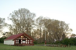
(traditional Māori meeting house) located in the East Coast township of Ruatoria in New Zealand. The marae is the within the land catchment of the descendants...
He was knighted, for services to education, in 2011. Reedy was born in Ruatoria on 16 July 1936, the son of Iritana Te Arohanui Hakuwai Reedy (née Haig)...
Ngāti Porou descent. Parata was educated at Ngata Memorial College in Ruatoria and at St Stephen's College near Bombay. After leaving school, he worked...
Mata River which it flows into about 10 kilometres (6 mi) upstream of Ruatoria. List of rivers of New Zealand "Place name detail: Aorangiwai River". New...
Collot, J-Y.; Lewis, K.; Lamarche, G.; Lallemand, S. (2001). "The giant Ruatoria debris avalanche on the northern Hikurangi margin, New Zealand: Result...
University of Auckland. In 1899 they moved to his family home at Kākāriki near Ruatoria. Ngata and her husband had fifteen children, of whom eleven (six girls...
 Global Information