You can help expand this article with text translated from the corresponding article in Hebrew. Click [show] for important translation instructions.
Machine translation, like DeepL or Google Translate, is a useful starting point for translations, but translators must revise errors as necessary and confirm that the translation is accurate, rather than simply copy-pasting machine-translated text into the English Wikipedia.
Do not translate text that appears unreliable or low-quality. If possible, verify the text with references provided in the foreign-language article.
You must provide copyright attribution in the edit summary accompanying your translation by providing an interlanguage link to the source of your translation. A model attribution edit summary is Content in this edit is translated from the existing Hebrew Wikipedia article at [[:he:כביש הטבעת המזרחי]]; see its history for attribution.
You may also add the template {{Translated|he|כביש הטבעת המזרחי}} to the talk page.
For more guidance, see Wikipedia:Translation.
Local Road 4370
Eastern Ring Road כביש הטבעת המזרחי
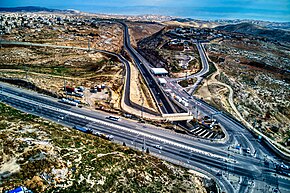
Highway 1 - Route 4370 Junction (Al-Issawiya Junction) - one can see the barrier between the Israeli and the Palestinian lanes
Route information
Length
3.7 km (2.3 mi)
Existed
9 January 2019–present
Location
Country
Israel
Major cities
Jerusalem
Highway system
Roads in Israel
Highways
Route 4370 or Eastern Ring Road, is a highway that connects the Geva Binyamin settlement in the Israeli-occupied West Bank and Jerusalem. It has been referred to by its critics as an "apartheid road" due to the fact that parts of it have separate traffic for Israeli plates and Palestinian plates.[1][2][3][4][5]
^"Focus - The 'apartheid road': West Bank highway sparks controversy". France 24. February 4, 2019.
^"New Jerusalem 'Apartheid Road' Opens, Separating Palestinians and Jewish Settlers" – via Haaretz.
^"Protest closes Israel's 'apartheid road' through West Bank". the Guardian. January 23, 2019.
^Giovannetti, Megan. "Israel opens 'apartheid road' in occupied West Bank". www.aljazeera.com. Retrieved 2021-12-17.
^"Road opens with segregated lanes for Israelis, Palestinians". UPI.
Route4370 or Eastern Ring Road, is a highway that connects the Geva Binyamin settlement in the Israeli-occupied West Bank and Jerusalem. It has been referred...
settlements and bypass roads" Israeli restrictions were tightened in 2007. Route4370, which has a concrete wall dividing the two sides, one designated for...
Apartheid". At a total length of 708 kilometres (440 mi) upon completion, the route traced by the barrier is more than double the length of the Green Line,...
Railroad-by-Railroad Photohistory. Minneapolis, Minnesota: Voyageur Press. ISBN 978-0-7603-4370-8. GE Transportation Systems. Earlier Locomotive Models – includes the Dash...
1944). "Enuresis in the Army". British Medical Journal. 2 (4370): 462–5. doi:10.1136/bmj.2.4370.462. PMC 2286383. PMID 20785684. Heaton LD, Anderson RS,...
Railroad-by-Railroad Photohistory. Minneapolis, Minnesota: Voyageur Press. ISBN 978-0-7603-4370-8. Solomon, Brian (2016). Field Guide to Trains: Locomotives and Rolling...
Railroad-by-Railroad Photohistory. Minneapolis, Minnesota: Voyageur Press. ISBN 978-0-7603-4370-8. Wikimedia Commons has media related to GE locomotives. Wabtec Former GE...
the Early Middle Ages. University of Pennsylvania Press. ISBN 978-0-8122-4370-3. Crampton, R. J. (1987). A Short History of Modern Bulgaria. Cambridge...
Railroad-by-Railroad Photohistory. Minneapolis, Minnesota: Voyageur Press. ISBN 978-0-7603-4370-8. Wikimedia Commons has media related to GE Evolution Series locomotives...
sites, such as northern Route 1001 between the Route 11 intersection and Amphoe Phrao, and southern Route 4006 between the Route 4 intersection (Ratchakrut)...
(Edition 3, 17 April 2009): Modified Point Mass Trajectory Model STANAG 4370 Environmental Testing STANAG 4381 (Edition 1, 8 July 1994): Blackout Lighting...
aircraft overseas. In April 1951 the runways were 6000-ft 2/20, 6530-ft 9/27, 4370-ft 14/32 and 4950-ft 17/35; the airport was all north of Winchester Road...
Perth railway station. The station is mostly used for out-of-town routes, while routes in and around Perth originate and terminate on Mill Street. The middle...
destinations for Nashik. The fort right in front of Saptashrungi is Markandya (4370 ft. form M.S.L). Vehicles are available till the foothills of Markandya from...
travelling on certain stretches of these highways (see Notes below). Road 4370 List of junctions and interchanges in Israel Roads in Israel Also referred...
Sana'a city, Yemen". BMC Research Notes. 12 (1): 339. doi:10.1186/s13104-019-4370-5. PMC 6570875. PMID 31200755. Oliver J, Malliya Wadu E, Pierse N, Moreland...
of related populations. They were connected by a common network of trade routes. This period is considered a developmental stage without any massive changes...
 Global Information