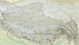
Rolwāling Valley (Nepali: रोल्वालिङ् भ्याली.), known as a (Gaurishankar) rural municipality, is a section of the Himalayas in east-central Nepal along the Tibet border.[2] Rolwaling Himal includes Melungtse 7181m and Melungtse II 7023m inside Tibet and Gaurishankar 7134m on the Nepal border with some 50 additional peaks over 6000m, all extending from the Nangpa La pass where the Mahalangur section begins, southwest to the Tamakosi River. The Labuche Himal section rises beyond the Tamakosi to the northwest. Rolwaling Himal is bounded on the south by the Rolwaling Valley which contain several small sherpa villages Tasi Nam, Simigau and Beding under rolwaling valley, Tasi Nam is the largest town of the area.
From Kathmandu five to six days are to reach Namche Bazaar around 10 days to mount Everest base camp, which have to Tasilapcha pass (5755 m). Visitors can trek to Everest base camp by crossing Tasilapcha, fly from Kathmandu to Lukla or walk from kharikhola.
Access to the valley and the mountains of the range is made on foot through an established trail system starting at Jagat, Bhiku rural municipality (230 km east of Kathmandu). Ten hours drive by local bus (5–6 hours by pvt car). A western style trek from Jagat to Beding will normally take four to five days. There are two ways to reach Beding, either by Tasinam village, or Simigua. From Tasinam trekkers can pass Daldung la pass (at 4500 m) and enjoy wonderful scenery, Himalayan species, cultures, flora and fauna. Tsho Rolpa (also Chho Rolpa) is one of the biggest glacial lakes in Nepal. The lake, which is located at an altitude of 4,580 metres (15,030 ft) in the Rolwaling Valley, Dolakha.
Rolwaling valley is under Gaurishankar Rural municipality. The first Western exploration of the area was made by Eric Shipton in 1951 during the reconnaissance of Mount Everest.[3]
Sherpa Clan in Rolwaling valley are Chusherpa or Ngonpa or Ngonba, Murminso , Rukpa, Sakywa, Lakshindo, Salakha & Sangu.
^ abCite error: The named reference peaklist was invoked but never defined (see the help page).
^Cite error: The named reference carter1985 was invoked but never defined (see the help page).
^Cite error: The named reference aj_1992 was invoked but never defined (see the help page).
section of the Himalayas in east-central Nepal along the Tibet border. RolwalingHimal includes Melungtse 7181m and Melungtse II 7023m inside Tibet and Gaurishankar...
south-central Tibet of China extending east from the pass Nangpa La between RolwalingHimal and Cho Oyu, to the Arun River. It includes Mount Everest, Lhotse,...
mountain in the Nepal Himalayas, is the second highest peak of the RolwalingHimal, behind Melungtse (7,181 m). The name comes from the Hindu goddess...
other English spelling: Menlungtse) is the highest mountain of the RolwalingHimal in the Himalayas. The peak has a long summit ridge capped by the east...
Lunag Ri is a mountain in the RolwalingHimal mountain range of the Himalayas. The 6,895 metres (22,621 ft) high Lunag Ri is located on the Himalayan...
areas of Kanchenjunga to Makalu Barun, Solukhumbu, RolwalingHimal, Helambu, Langtang, Ganesh Himal, Manaslu, Annapurna, Dolpa, Rara Lake and Humla finishing...
Numbur is a glaciated mountain located in the RolwalingHimal mountain range of Nepal. The 6,958 metres (22,828 ft) high Numbur is located at 43 km southwest...
earlier on May 23, 2003 by 25-year-old Pemba Dorjie, a Sherpa from RolwalingHimal. Lakpa Gelu was the climbing Sardar of the 12-member "Jubiläums Expedition...
of RolwalingHimal and east of Shishapangma. The peak belongs to a little-known section of the Himalaya variously called Labuche Himal, Pamari Himal and...
कर्योलुंग, romanized: Kareluṅ Ḍā̃ḍā) is a mountain located in the RolwalingHimal range of the Himalayas in Solukhumbu District, Province No. 1, Nepal...
nationalgeographic.com "Sherpa and American Teams Climb First Ascents in RolwalingHimal". Alpinist.com. 2018-05-31. Retrieved 2018-07-25. "In Animal Planet's...
other Central Asian mountains. The first western exploration of the RolwalingHimal was made by Shipton in 1951 during the reconnaissance of Mount Everest...
Responsiveness to Climate Warming: Insights from a Krummholz Treeline in RolwalingHimal, Nepal". In Singh, R.; Schickhoff, U.; Mal, S. (eds.). Climate Change...
river and one-third to the east. To the north east lies the impressive RolwalingHimal to the western edge of which are such peaks as Gauri Shankar and Melungtse...
Ri Langtang Lirung Yala Peak west of Arun River RolwalingHimal Gauri Sankar Melungtse Mahalangur Himal Ama Dablam Baruntse Chamlang Cholatse Cho Oyu Cho...
Price (America), June 16, 1999. 1999 East Face Milarepa, 6262 meters, RolwalingHimal, Himalaya, Nepal. First ascent with Mark Price (America), October 11-13...
in the eastern regions of Nepal, namely in Solukhumba, Khatra, Kama, Rolwaling, Barun and Pharak valleys, though some live farther West in the Bigu and...
Tibetans and the Khumbu's Sherpas. This pass separates the Khumbu and Rolwaling Himalayas. Due to its proximity to this pass and the generally moderate...
Dolakha District and Ramechhap District. Just above the confluence of Rolwaling Chu, Upper Tamakoshi Hydroelectric Project has been operating since July...
ISBN 978-0-08-047408-3. Meiners, Sigrid (1999). "The history of glaciation of the Rolwaling and Kangchenjunga Himalayas". GeoJournal. 47 (1): 341–372. doi:10.1023/A:1007065727298...
Kathmandu Valley to the southern slopes of Langtang, Ganesh, Jugal Himal and Rolwaling probably since prehistoric times, have been mentioned in various...
Nepal and Tibet around Mount Everest are the Khenbalung, Solukhumbu, Rolwaling, Rongshar, Kyirong and Nubri sacred valleys. The Sherpa people discovered...
 Global Information