51°37′00″N0°52′18″E / 51.6166°N 0.8718°E / 51.6166; 0.8718 (Mouth of River Roach)
• elevation
0 m (0 ft)
Length
22 km (14 mi)
Basin features
River system
River Crouch
Designation
Ramsar Wetland
Official name
Crouch & Roach Estuaries
Designated
24 March 1995
Reference no.
721[1]
v
t
e
River Roach
Legend
River Crouch
The Middleway / Havengore Creek
Paglesham Pool
Paglesham Reach
Potton Creek
Barlinghall Creek
1
Prittle Brook
Stambridge Mills
Weir
Tidal mill pound
Salt Bridge, Rochford
Rochford Reservoir
Weir on Noblesgreen Ditch
Shenfield–Southend line
2
Eastwood Brook
Rectory Road Hawkwell
B1013 Cherry Orchard Way
Hockley Brook
Cherry Orchard Jubilee Country Park
Thorpe Close (becomes Main River)
B1013 Main Road Hawkwell
4
Source of Hawkwell Brook
3
Source of Noblesgreen Ditch
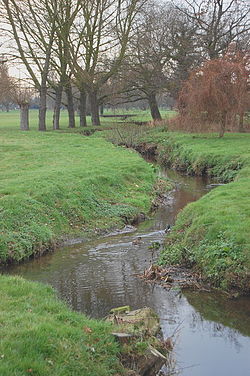
The River Roach is a river that flows entirely through the English county of Essex. It is one of four main streams that originate in the Rayleigh Hills to the west, and flow east. They then flow towards the centre of the Rochford Basin, a circular feature which may have been caused by an asteroid impact in the Late Oligocene or Early Miocene periods. To the east of Rochford, the river becomes tidal, and is governed by the Crouch Harbour Authority. It joins the River Crouch between Wallasea Island and Foulness Island. To the west of Rochford, there is some doubt as to which of the four streams is officially the Roach.
At Stambridge, there was a tidal mill from at least the 1500s, although few details are known until it was rebuilt in 1809. A pound was filled by the incoming tide, and was released to drive a water wheel as the tide fell. On spring tides, this gave around 7 hours of operation, which gradually decreased as the tides reduced, and at neap tides, the operation of the mill was entirely dependent on the flow from the upper river. Rankins, the millers, objected to plans by the Great Eastern Railway to build a dam and reservoirs in Rochford, as it would damage their operation, but a single reservoir was authorised in 1904.
The river channels are designated as "heavily modified" from their natural state by the Environment Agency, who measure the water quality. This is moderate for most of the tributaries, and the chemical status has improved since 2013. Charles Darwin's HMS Beagle was moored on the river from 1850 as a Coast Guard watch ship. It was sold for breaking, but an archaeological survey concluded in 2008 that much of it still remains buried beneath the mud near Paglesham. The Paglesham Reach is also significant for its native oysters.
^"Crouch & Roach Estuaries". Ramsar Sites Information Service. Retrieved 25 April 2018.
The RiverRoach is a river that flows entirely through the English county of Essex. It is one of four main streams that originate in the Rayleigh Hills...
community Roach, Nevada, a ghost town Roach, West Virginia, an unincorporated community RoachRiver (Maine), a river in Piscataquis County RoachRiver (Virginia)...
The roach, or rutilus roach (Rutilus rutilus), also known as the common roach, is a fresh- and brackish-water fish of the family Cyprinidae, native to...
William Roach AC (8 January 1956 – 30 July 2022) was an Australian singer-songwriter and Aboriginal activist. Often referred to as "Uncle Archie", Roach was...
Essex, England. It is bounded to the north by the River Crouch, to the south east by the RiverRoach, and to the west by Paglesham Pool and the narrow...
mid-river in the RiverRoach which forms part of an extensive maze of waterways and marshes known as The River Crouch and RiverRoach Tidal River System...
The Roach Valley Way is a long-distance footpath in south-east Essex, England. The 23-mile (37 km) circular path is centred on Rochford and the River Crouch...
speed, and the water forms whirlpools because of flows from the River Crouch and RiverRoach. Under such conditions, the direction of the shore cannot be...
The Roaches (from the French les roches – the rocks) is a prominent rocky ridge above Leek and Tittesworth Reservoir in the Staffordshire Peak District...
The California roach (Hesperoleucus symmetricus) is a cyprinid fish native to western North America and abundant in the intermittent streams throughout...
catchment River Crouch (MS) RiverRoach (R) Blackwater catchment River Blackwater (MS) (known as River Pant upstream) River Chelmer (R) River Ter (L) River Brain...
Creek Willis River Little Willis River Byrd Creek Rivanna River Mechunk Creek Buck Island Creek North Fork Rivanna River Lynch RiverRoachRiver South Fork...
following is a complete list of the 220 Our Gang short films produced by Hal Roach Studios and/or Metro-Goldwyn-Mayer between 1922 and 1944, numbered by order...
RiverRoach, the brook rises in Thundersley and passes through Hadleigh, Leigh-on-Sea, Westcliff, Prittlewell, Rochford and discharges into the Roach...
Hal Roach Studios was an American motion picture and television production studio. Known as The Laugh Factory to the World, it was founded by producer...
District Council. The Roach Valley Way is a 23-mile (37 km) circular path centred on Rochford and the River Crouch and RiverRoach estuaries. Rochford Hundred...
through an existing sluice in the sea wall. The river continues eastwards, and is joined by the RiverRoach at the eastern end of Wallsea Island. It flows...
Maine) Kennebec River Moose River South Branch Moose River East Branch Moose River West Branch Moose RiverRoachRiver Moxie Stream Dead River – also called...
Eastend and Churchend, which are situated near the River Crouch and Paglesham Creek. It is part of the Roach Valley Conservation Zone. At the Eastend is The...
"Largest Rivers in the United States". US Geological Survey. Archived from the original on 13 May 2020. Retrieved 25 January 2015. Roach, John (18 June...
the Rochford district in Essex, England. It is located north of the RiverRoach between Rochford and Paglesham. The parish includes the village of Great...
speed, and the water forms whirlpools because of flows from the River Crouch and RiverRoach. Under such conditions, the direction of the shore cannot be...
 Global Information