This article is about the river in Cornwall. For two rivers in Devon, see River Lew.
River Looe
East Looe River, West Looe River
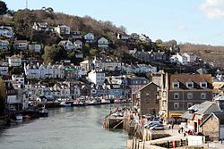
River Looe in Looe
Sketchmap of the East Looe and West Looe rivers in Cornwall
Location
Country
England
State
Cornwall
Physical characteristics
Length
30.48 mi (49.05 km)
Basin size
36.3 sq mi (94 km2)
v
t
e
River Looe
Legend
Bodmin Moor
A38
B3254
B3254
Upper Tremadart Mill
Colls
A387 Looe Bridge
West Looe
East Looe
English Channel
The River Looe (Cornish: Logh, meaning deep water inlet)[1] is a river in south-east Cornwall, which flows into the English Channel at Looe.[2] It has two main branches, the East Looe River and the West Looe River. The eastern branch has its source near St Cleer only 0.31 miles (0.5 km) away from the Golitha Falls on the River Fowey, and flows south, passing close to the western outskirts of Liskeard. The western branch has its source near Dobwalls.[2]
South of Liskeard, the Looe Valley Line railway follows the course of the East Looe River to Looe. The railway is so close to the river that flooding is a common occurrence.[3]
The lowest stretch of the rivers combine to form the tidal harbour and estuary of Looe. The combined length of the two rivers (including the tidal confluence) is 30.48 miles (49.05 km).[4][5][6]
The river is tidal to Watergate on the West Looe and Sandplace on the East Looe. After Sandplace, the river was connected to the Liskeard and Looe Union Canal so that minerals and stone could be transported from the workings and quarries above Liskeard to the harbour at Looe.[7] The tidal estuarine section is an example of a Ria (a drowned river valley) and at low tide, the rivers almost dry up to a very small natural level.[8]
^Ekwall, Eilert (1960). The concise Oxford dictionary of English place-names (4 ed.). Oxford: Clarendon Press. p. 304. OCLC 400936.
^"Seaton, Looe & Fowey Catchment Management Plan" (PDF). environmentdata,org. 4.8.2 Local Perspective: National Rivers Authority. December 1994. p. 56. Retrieved 22 December 2016.{{cite web}}: CS1 maint: location (link)
^"West Looe River". environment.data.gov.uk. Environment Agency. Retrieved 22 December 2016.
^"Looe". environment.data.gov.uk. Environment Agency. Retrieved 22 December 2016.
^"East Looe River". environment.data.gov.uk. Environment Agency. Retrieved 22 December 2016.
^Daniel, John (1854). "Hundred of West". A geography of Cornwall, historical ecclesiastical, civil, natural, and parochial. London: Longman & Co. p. 124. OCLC 58545739.
The RiverLooe (Cornish: Logh, meaning deep water inlet) is a river in south-east Cornwall, which flows into the English Channel at Looe. It has two main...
2011 census. Looe is 20 miles (32 km) west of Plymouth and seven miles (11 km) south of Liskeard, divided in two by the RiverLooe, East Looe (Cornish: Logh)...
the East LooeRiver for much of its course. It is operated by Great Western Railway. The Looe Valley Line was opened as the Liskeard and Looe Railway on...
in south-west England, which leads to the mouth of the RiverLooe in Looe Bay. The town of Looe sits on the west and east side of the estuary. The estuary...
the scenic Looe Valley Line 8.75 miles (14 km) south of Liskeard. It faces out across the estuary of the RiverLooe. The Liskeard and Looe Railway was...
The Liskeard and Looe Union Canal was a broad canal between Liskeard and Looe in Cornwall, United Kingdom. It was almost 6 miles (9.7 km) long and had...
Looe Guildhall is a municipal building in Fore Street in Looe, Cornwall, England. The structure, which is currently used as a community events venue,...
Neot River (R) (or River Loveny) Pol catchment River Pol (MS) (or Polperrro River) Looe catchment RiverLooe (MS) East LooeRiver (Ls) West LooeRiver (Rs)...
fishing village of Polperro, at the mouth of the Pol River, and the fishing port of Looe on the RiverLooe are both popular with tourists. The interior of...
Looe Bridge is a bridge in Looe, Cornwall, across the RiverLooe. Built in the 1850s to replace a dangerous 15th-century structure, the bridge carries...
these rivers and streams: River Allen, River Caerhays, River Camel, RiverLooe (East LooeRiver), (West LooeRiver), River Fal, River Fowey, River Gannel...
Whitsand Bay Rivers of Cornwall River Truro River Camel River Fal River Fowey River Gannel Gover Stream Hamoaze Helford RiverRiverLooeRiver Lynher St...
unlikely to be derived from 'Coffar', since it was known as the 'River Loe or RiverLooe' around four hundred years ago, in Carew's time, according to the...
enters Looe, passing through Hannafore, West Looe then, after crossing the RiverLooe on a seven-span bridge. The path continues up onto the cliff then heads...
Poldhu Polperro Museum of Submarine Telegraphy Restormel Castle River Fowey RiverLooe Roseland Peninsula Rough Tor Royal Cornwall Museum South Crofty...
The Liskeard and Looe Railway was a railway originally built between Moorswater, in the valley west of Liskeard, and Looe, in Cornwall, England, UK, and...
Germans & Looe Railway was a proposed new railway in Cornwall by the Great Western Railway, providing a direct connection between St Germans and Looe. The...
contains numerous small rivers and streams. The border between Cornwall and the neighbouring county of Devon is mostly the River Tamar. Wikimedia Commons...
streets in Looe were flooded with seawater. Areas of Northern England were affected by floods on 9 April. In Tyne and Wear, parts of the River Tyne burst...
the service is run via Looe, Polperro, Lansallos and Greenbank. Other transport includes the Polruan ferry, which crosses the river to and from Fowey every...
through which runs the River Pol, is 7 miles (11 km) east of Fowey and 4 miles (6 km) west of the neighbouring town of Looe and 25 miles (40 km) west...
 Global Information