Map of Northumberland - showing the source and mouth
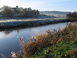
The River Coquet/ˈkoʊkət/ runs through the county of Northumberland, England, discharging into the North Sea on the east coast at Amble. It rises in the Cheviot Hills on the border between England and Scotland, and follows a winding course across the landscape ("Coquetdale"). The upper reaches are bordered by the Otterburn Ranges military training ground, and are crossed by a number of bridges built in the 20th century. It passes a number of small villages and hamlets, and feeds one of the lakes created by extraction of gravel that form the Caistron Nature Reserve, before reaching the town of Rothbury, where it is crossed by a grade II listed bridge. Below the town is Thrum Mill, the restoration of which was featured on Channel 4 television.
It loops around Brinkburn Priory, founded in the 1130s for Augustinian Canons, and its associated mill. At Felton it is crossed by two bridges, one dating from the 15th century, and its replacement, built in 1927, both of which are listed structures. Below the bridges is a sewage treatment works, built in the 1990s. At Brainshaugh, the river passes over a large horseshoe dam, built in 1775 by the engineer John Smeaton to power an iron and tin works, which later became a woollen mill, and subsequently one of the first factories to be powered by hydroelectricity. Before it reaches Warkworth, the river passes over another dam, which is now part of the intake works for Warkworth Water Treatment Works, which supplies drinking water to some 92,000 customers in the region. Below the dam the river is tidal, and Warkworth Castle is built in a loop of the Coquet. The river reaches the sea at Warkworth Harbour in Amble, where there is a Royal National Lifeboat Institution lifeboat station.
The river has been used as a source of power, as a number of mills have been constructed along its length. One of the earliest was on Hepden Burn, a tributary in the upper reaches, which was mentioned in the early 13th century, but was not subsequently developed, due to unrest in the area. Archaeological investigation between 2010 and 2013 revealed one of the few unaltered medieval mill sites in Britain, and pushed the development of the breast-shot water wheel back by three centuries. Although most of the mills were used for grinding corn, some were used for fulling of wool, and that at Brainshaugh for an industrial process. The earliest was at Warkworth, the rent from which was used to provide a light in St Cuthbert's shrine in 1214.
The earliest known reference to the River Coquet is found in the Ravenna Cosmography, which dates from the 8th century. The water quality of the non-tidal river is good ecologically, and only in the final tidal section is the water affected by run-off from agricultural land, reducing the quality to moderate.
source mouth The RiverCoquet /ˈkoʊkət/ runs through the county of Northumberland, England, discharging into the North Sea on the east coast at Amble....
is a market town and civil parish in Northumberland, England, on the RiverCoquet. It is 14 miles (22.5 km) north-west of Morpeth and 26 miles (42 km)...
Look up coquet in Wiktionary, the free dictionary. Coquet may refer to: a flirtatious female RiverCoquet, a river of Northumberland Coquet Island Amélie...
county of Northumberland. The village and castle occupy a loop of the RiverCoquet, less than a mile from England's north-east coast. When the castle was...
North Sea coast of Northumberland, England, at the mouth of the RiverCoquet; Coquet Island is visible from its beaches and harbour. In 2011, the parish...
Somerset Cheshire — Cheshire county Coquetdale cheese — the valley of the RiverCoquet, Northumberland Cornish Blue, Cornish Brie and Cornish Yarg — the county...
Thropton is a hamlet in Northumberland, England, located on the RiverCoquet, and its tributary Wreigh Burn. With a population of 458 (2011 census) it...
The Coquet Stop Line, which ran from Amble in Northumberland up the valley of the RiverCoquet, formed part of the defences constructed to meet the threat...
the Northumberland National Park, England. It is a tributary of the RiverCoquet and 2.7 miles (4.3 km) in length. Rising as the Outer Sike at the edge...
parish of Acklington, in Northumberland, England. It is located on the RiverCoquet, roughly 6 miles south of Alnwick and around 3 miles west of Amble. Guyzance...
germanica includes the River Tweed and River Don in Scotland, the RiverCoquet in England, the River Wye in Wales and the River Liffey in Ireland. In Germany...
Brinkburn is a civil parish in Northumberland, England. It is divided by the RiverCoquet. The parish includes the hamlet of Pauperhaugh. The name "Brinkburn"...
upland river on the southern flanks of the Cheviot Hills, in the Northumberland National Park, England. It is a tributary of the RiverCoquet and is about...
former monastery built, starting in the 12th century, on a bend of the RiverCoquet, about 4 miles (6 km) east of Rothbury, Northumberland, England. The...
With a 110-yard (100 m) cordon established on the north bank of the RiverCoquet, close to a rainwater culvert which runs under the village, police negotiated...
priest's house built onto and within a cliff-face on the north bank of the RiverCoquet in Northumberland, England, close to Warkworth Castle and the village...
covering 40 miles (64 km) of coastline from Berwick-Upon-Tweed to the RiverCoquet estuary in the Northeast of England. Features include: Alnmouth, Bamburgh...
Robert Lilburne, these mounted forces won a considerable success at the RiverCoquet. This reverse, coupled with the existence of Langdale's Royalist force...
development.[citation needed] The historic port of Amble is located on the RiverCoquet estuary and is the southern gateway to Northumberland's Heritage Coast...
Wear shortly downstream. The other major rivers in Northumberland are, from south to north, the Blyth, Coquet, Aln, Wansbeck and Tweed, the last of which...
covered County Durham and the southern part of Northumberland up to the RiverCoquet, and eastwards into the Pennines. Whithorn covered most of Dumfries and...
12th century, situated at the west end of the village overlooking the RiverCoquet. It is a Scheduled Ancient Monument and a Grade I listed building. It...
Cheviot hills encompass the slopes running down to the valley of the riverCoquet. At the centre of the range is an outcrop of Early Devonian granite,...
Team River Blyth River Wansbeck River Font RiverCoquetRiver Aln River Tweed Whiteadder Water, Scotland Blackadder Water, Scotland River Till River Glen...
 Global Information