The Ritner Creek Bridge was the last covered bridge on a state highway in Oregon. It carried Oregon Route 223 (OR 223) over Ritner Creek between Pedee and Kings Valley, about 15 miles (24 km) south of Dallas, or 10 miles (16 km) north of the junction with U.S. Route 20 (US 20) in Wren. Built in 1927, in 1976 the bridge was lifted from its foundation and relocated just downstream of its original site and replaced by a concrete bridge. The bridge was constructed in 1927 by Hamer and Curry Contractors to Oregon State Highway Commission plans. The initial construction cost was $6,964. The original portal design was rounded at the edges but was changed to a square design in the early 1960s to accommodate larger loads to pass.[1]
The 73-foot-long (22 m) bridge was named for pioneer Sebastian Ritner, who arrived in the area in 1845. In 1974 the bridge was declared structurally unsafe and scheduled for removal. Local residents started a petition to keep the bridge, which became a ballot measure in May 1974. The measure passed and it was moved, replaced by a new highway bridge.[2] The bridge was the last of its kind to serve on a state highway in Oregon. It was added to the National Register of Historic Places in 1979, following nomination by the State Historic Preservation Office due to the fact that while nearly 450 covered bridges existed in Oregon at the time of the bridge's construction, by the mid-1970s fewer than 60 were left in the state.[3]
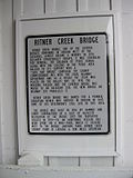
Sign detailing the history of the bridge
Interior of the bridge
^Ritner Creek Covered Bridge
^"Ritner Creek Bridge". Retrieved November 4, 2015.
^"Ritner Creek Covered Bridge".
and 14 Related for: Ritner Creek Bridge information
RitnerCreek is a tributary of the Luckiamute River in Polk County in the U.S. state of Oregon. The creek begins near Bald Mountain in the Central Oregon...
Dallas, it ends at an intersection with OR 22. The RitnerCreekBridge was the last covered bridge on a state highway in Oregon. It was on OR 223 between...
Tunkhannock Creek Viaduct (also known as the Nicholson Bridge and the Tunkhannock Viaduct) is a concrete deck arch bridge on the Nicholson Cutoff rail...
Historic Highway Bridges of Oregon (2nd ed.). Portland: Oregon Historical Society Press. p. 215. ISBN 0-87595-205-4. "RitnerCreekBridge". Geographic Names...
January 12, 2022. With accompanying 33 photos "Tanner CreekBridge". OregonHikers. "Hood River Bridge Demolition, 1982". Retrieved January 12, 2022. Includes...
under Tunnel Hill Road between Taswell and English in Crawford County Ritner Tunnel/The Big Tunnel, rail tunnel, 1857, 1,731 feet (528 m) long, CSX railroad...
As of January 2020[update], the full line is being substituted by a bus bridge to allow for rolling stock maintenance, track repairs, and a nearby highway...
Creek Pedee CreekRitnerCreek Kinsey Creek Clayton Creek Love Creek Sheythe Creek Bump Creek Maxfield Creek Price Creek Woods Creek Plunkett Creek Watson...
641 heads east into a mix of fields and woods and crosses Conodoguinet Creek, curving northeast and heading into North Newton Township. The road becomes...
Philadelphia, passing to the west of Jefferson Methodist Hospital between Ritner Street and Wolf Street. PA 611 runs to the west of South Philadelphia High...
crosses the Conodoguinet Creek into Lower Mifflin Township and curves north through more agricultural areas, coming to a bridge over I-76 (Pennsylvania...
25 – John Sumner, Archbishop of Canterbury (d. 1862) March 25 – Joseph Ritner, American politician (d. 1869) March 29 – Jørgen Jørgensen, Danish adventurer...
 Sign detailing the history of the bridge
 Interior of the bridge
 Global Information

