Dean Allison, Chris Bittle, Vance Badawey, Tony Baldinelli
• MPPs
Jeff Burch, Wayne Gates, Sam Oosterhoff, Jennie Stevens
Area
[2]
• Land
1,854.23 km2 (715.92 sq mi)
Population
(2016)[2]
• Total
447,888
• Density
241.5/km2 (625/sq mi)
Gross Metropolitan Product
• St. Catharines – Niagara CMA
CA$17.4billion (2020)[3]
Time zone
UTC−05:00 (EST)
• Summer (DST)
UTC−04:00 (EDT)
Website
www.niagararegion.ca
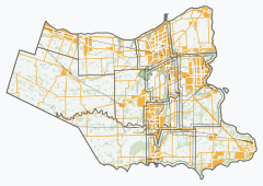
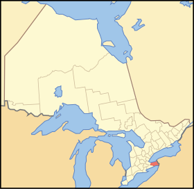
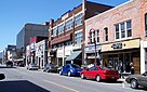
The Regional Municipality of Niagara, also colloquially known as the Niagara Region or Region of Niagara, is a regional municipality comprising twelve municipalities of Southern Ontario, Canada. The regional seat is in Thorold. It is the southern end of the Golden Horseshoe, the largest megalopolis in Canada.
The region occupies most of the Niagara Peninsula. Its eastern boundary is the Niagara River, which is also the border with the US state of New York. It is bounded on the north by Lake Ontario and on the south by Lake Erie.
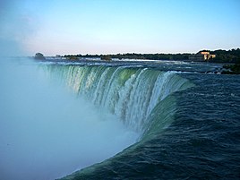
Unique natural landscapes make the Niagara Region an important centre for agriculture and tourism in Canada. The most important agricultural enterprise in Niagara is viticulture, or winemaking. The Niagara Wine Route, which connects visitors to dozens of wineries, is a growing tourism draw while the internationally renowned Niagara Falls is one of Canada's major tourist attractions. Along with Shaw Festival, held annually in Niagara-on-the-Lake, and the Welland Canal, the Regional Municipality of Niagara receives up to 12 million visitors each year.
Niagara Region is situated on treaty land. This land has a rich history of First Nations such as the Neutral, the Haudenosaunee, and the Anishinaabe, including the Mississaugas of the Credit First Nation.[4] There are many First Nations, Métis, and Inuit people from across Turtle Island that continue to live and work in Niagara today.
^"Regional Municipality of Niagara". Geographical Names Data Base. Natural Resources Canada.
^ ab"Census Profile, 2016 Census Niagara, Regional municipality". Statistics Canada. Retrieved July 2, 2019.
^"Gross domestic product (GDP) at basic prices, by census metropolitan area (CMA)". statcan.gc.ca.
^"Subject: Updated Land Acknowledgement Statements". Regional Municipality of Niagara publications. August 26, 2021. Retrieved May 8, 2023.
and 23 Related for: Regional Municipality of Niagara information
lists all of the numbered regional roads in RegionalMunicipalityofNiagara, Ontario. This list also contains all recently downloaded regional roads (heretofore...
greater part of the peninsula is incorporated as the RegionalMunicipalityofNiagara. Cities in the region include St. Catharines, Niagara Falls, Thorold...
The NiagaraRegional Council is the governing body of the RegionalMunicipalityofNiagara in Ontario, Canada. Council meets at Niagara Region Headquarters...
The NiagaraRegional Police Service (NRPS) is a regional police service maintained by the RegionalMunicipalityofNiagara in the Canadian province of Ontario...
Niagara Falls (/naɪˈæɡərə/) is a group of three waterfalls at the southern end ofNiagara Gorge, spanning the border between the province of Ontario in...
Niagara College of Applied Arts and Technology (frequently shortened to Niagara College and branded as Niagara College Canada) is a public College of...
the upstream erosion of the Niagara Escarpment by the Niagara River. Niagara Falls is located along the boundary of the Niagara Escarpment and has been...
Louth Niagara Welland County Bertie Crowland Humberstone Pelham Thorold Stamford Wainfleet Willoughby Current Municipalities Town of Fort Erie Town of Grimsby...
The RegionalMunicipalityof Halton, or Halton Region, is a regionalmunicipality in Ontario, Canada, located in the Golden Horseshoe of Southern Ontario...
Niagara Gorge is an 11 km (6.8 mi) long canyon carved by the Niagara River along the Canada–United States border, between the U.S. state of New York and...
The Niagara River (/naɪˈæɡərə/) is a river that flows north from Lake Erie to Lake Ontario. It forms part of the border between the province of Ontario...
provincial government announced a review of the eight regionalmunicipalities in the province (Durham, Halton, Muskoka, Niagara, Oxford, Peel, Waterloo, and York)...
Dick (née MacLean, born October 13, 1920) was a Canadian socialite suspected of killing her husband and son although she never confessed to either crime....
former general manager of the Arizona Coyotes of the National Hockey League (NHL). Previously, he served as assistant general manager of the Coyotes. Prior...
in the RegionalMunicipalityofNiagara. Its head office is in St. Catharines. The DSBN operates schools in each of the twelve municipalities in the region...
Montrose Yard is a former Canadian Pacific Railway marshalling yard in Niagara Falls, Ontario, Canada. It was originally built for the New York Central...
in Ontario, Canada, located on the Niagara Escarpment. It is also the seat of the RegionalMunicipalityofNiagara. The Welland Canal passes through the...
downtown districts ofNiagara Falls, Ontario, and Niagara Falls, New York. This bridge is located approximately 1.5 kilometres (0.9 mi) north of the Rainbow...
Located in the town of Grimsby in the RegionalMunicipalityofNiagara, it would be a stop on the Lakeshore West line, east of the proposed Confederation...
transferred to the City ofNiagara Falls and the RegionalMunicipalityofNiagara, although the Ministry of Transportation of Ontario (MTO) still assists...
The Niagara Region Wind Farm is a wind farm located in the RegionalMunicipalityofNiagara, Ontario. The wind farms generates 230 MW of electricity and...
 Global Information