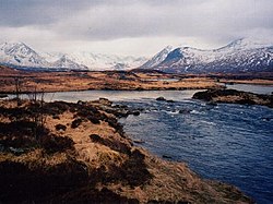
Rannoch Moor (/ˈrænəx/ⓘ; Scottish Gaelic: Mòinteach Rai(th)neach) is an expanse of around 50 square miles (130 km2) of boggy moorland to the west of Loch Rannoch in Scotland, where it extends from and into westerly Perth and Kinross, northerly Lochaber (in Highland), and the area of Highland Scotland toward its south-west, northern Argyll and Bute. Rannoch Moor is designated a Site of Special Scientific Interest (SSSI) and a Special Area of Conservation.[2] Much of the western part of the moor lies within the Ben Nevis and Glen Coe National Scenic Area,[3] one of 40 such areas in Scotland.[4]
It is notable for its wildlife, and is particularly famous as being the sole British location for the Rannoch-rush, named after the moor.[5] It was frequently visited by Horace Donisthorpe who collected many unusual species of ants on the moor and surrounding hilly ground. Today it is still one of the few remaining habitats for Formica exsecta, the "narrow-headed ant", although recent surveys have failed to produce any sign of Formica pratensis, which Donisthorpe recorded in the area in the early part of the 20th century.
Peat deposits pose major difficulties to builders of roads and railways. When the West Highland Line was built across Rannoch Moor, its builders had to float the tracks on a mattress of tree roots, brushwood and thousands of tons of earth and ashes. Corrour railway station, the UK's highest, and one of its most remote being 10 miles (16 km) from the nearest public road, is located on this section of the line at 1,339 feet (408 m).[6] The line takes gentle curves totalling 23 miles (37 km) across the moorland. The A82 road crosses western Rannoch Moor on its way to Glen Coe and Fort William.
The desolate and isolated Gorton was a private railway station built near Meall a Ghortain that once housed a school for local railway workers' children, and still serves as the Gorton Crossing engineers' siding.
^"Rannoch Moor". Ramsar Sites Information Service. Retrieved 25 April 2018.
^1331, 8348. Rannoch Moor, Scottish National Heritage Sitelink. Scottish National Heritage. 2012.
^"Map: Ben Nevis and Glen Coe National Scenic Area" (PDF). Scottish Natural Heritage. December 2010. Retrieved 14 February 2018.
^"National Scenic Areas". Scottish Natural Heritage. Retrieved 17 January 2018.
^"Rannoch Moor Special Area of Conservation". Joint Nature Conservation Committee. Retrieved 26 April 2018.
^Corrour couple make plea over Trainspotting station Herald Scotland
RannochMoor (/ˈrænəx/ ; Scottish Gaelic: Mòinteach Rai(th)neach) is an expanse of around 50 square miles (130 km2) of boggy moorland to the west of Loch...
Rannoch can be found, whilst the wild expanse of RannochMoor extends to the west of the loch. The area surrounding Loch Rannoch, along with Rannoch Moor...
The road passes close to numerous landmarks, including Loch Lomond, RannochMoor, Glen Coe, the Ballachulish Bridge, Ben Nevis, the Commando Memorial...
the area include Loch Rannoch and RannochMoor. The loch is in the northwest of the council area of Perth and Kinross. The moor extends further west,...
Etive (Scottish Gaelic: Abhainn Èite) rises on the peaks surrounding RannochMoor, with several tributary streams coming together at the Kings House Hotel...
Scheuchzeria palustris (Rannoch-rush, or pod grass), is a flowering plant in the family Scheuchzeriaceae, in which there is only one species and Scheuchzeria...
Rannoch Barracks Loch RannochRannoch School Kinloch Rannoch Dunalastair Tummel hydro-electric power scheme The Soldiers' Trenches, Moor of Rannoch Brailsford...
less of climbing. After around 100 km (60 mi), as they started over RannochMoor, they decided to cease competing against each other and ran together...
from Strathmore in the east, to the Pass of Drumochter in the north, RannochMoor and Ben Lui in the west, and Aberfoyle in the south; it borders the counties...
to Mallaig climbs onto RannochMoor, past the former crossing point at Gorton Crossing to Rannoch station. In winter, the moor is often covered with snow...
work. After making the Loch Awe sculpture, at RannochMoor he began what became the Celtic (Kinlock Rannoch) Scottish Symphony performance, developed further...
isolated position about 2 km east of Glen Etive, stands on the edge of RannochMoor. It faces Buachaille Etive Mor which makes it a popular hostelry with...
Glen Coe on the West Highland Way following the old military road over RannochMoor which crosses the River Etive at the Kings House Hotel. From there it...
included North Lorne, Glen Coe, Nether Lochaber, the western part of the RannochMoor, the Road to the Isles, Moidart, Ardgour, Morvern, Sunart, Ardnamurchan...
Etive (Scottish Gaelic: Abhainn Èite) rises on the peaks surrounding RannochMoor, with several tributary streams coming together at the Kings House Hotel...
house on the ridge". It lies in Strathfillan, at the southern edge of RannochMoor. Tyndrum is a popular tourist village, and a noted stop on the A82 for...
northern edge of RannochMoor. It is not accessible by any public roads. The nearest road, the B846 road from Loch Rannoch to Rannoch station, is a ten-mile...
enabling soldiers at Rannoch Barracks to move more freely around the district. The Soldiers' Trenches were dug on nearby RannochMoor in an unsuccessful...
Nevis Loch Rannoch Loch Tay Lochranza Luss Meall a' Bhuiridh (Glencoe Ski Centre) Scottish Sea Life Sanctuary at Loch Creran RannochMoor Red Cuillin...
landmark on RannochMoor situated on the old 'Road to the Isles'. During the construction of the B846 road from Kinloch Rannoch to Rannoch railway station...
situated at the eastern end of Loch Ossian on the Corrour Estate on RannochMoor, Scotland. It is a large modernist residence (also let as luxury holiday...
and railways. When the West Highland railway line was built across RannochMoor in western Scotland, its builders had to float the tracks on a multi-thousand-ton...
 Global Information