Otamatea River, Wheao River, Whirinaki River, Horomanga River
Waterbodies
Lake Āniwaniwa, Lake Matahina
Waterfalls
Āniwaniwa Falls
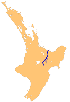
The Rangitaiki River is the longest river in the Bay of Plenty region in New Zealand's North Island. It is 155 kilometres (96 mi) long, and rises inland from northern Hawkes Bay to the east of the Kaingaroa Forest.
The Rangitaiki catchment covers an area of 3005 km2.[2]
It flows in a generally northeastward direction, passing through the town of Murupara and skirting close to the western edge of Te Urewera National Park before turning northwards, flowing past Edgecumbe and into the Bay of Plenty close to Thornton.
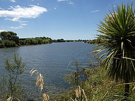
There are two man-made lakes on the Rangitaiki formed by hydro-electric dams, Lake Āniwaniwa (formerly Lake Aniwhenua).[3] and Lake Matahina.
^"NIWA Water & soil miscellaneous publication no. 48 (1983)" (PDF). Archived (PDF) from the original on 13 April 2021. Retrieved 13 April 2021.
^Cite error: The named reference LAWA1 was invoked but never defined (see the help page).
^Cite error: The named reference DOS was invoked but never defined (see the help page).
The RangitaikiRiver is the longest river in the Bay of Plenty region in New Zealand's North Island. It is 155 kilometres (96 mi) long, and rises inland...
Rangitaiki is a rural community in the Taupō District and Bay of Plenty Region of New Zealand's North Island, located near the source of Rangitaiki River...
Kaingaroa Forest and Te Urewera protected area, on the banks of the RangitaikiRiver, 65 kilometres southeast of Rotorua. Indigenous Māori also make up...
service town for the agricultural region surrounding the plains of the RangitaikiRiver, which flows through the town. State Highway 2 and the Tāneatua Branch...
north-north-west of Edgecumbe, on the Rangitaiki Plains (the floodplain of the RangitaikiRiver, the Tarawera River and the Whakatane River). It was the most damaging...
in Bay of Plenty in New Zealand on the RangitaikiRiver downstream of the Aniwhenua Power Station. The river was dammed to form Lake Matahina from which...
Te Teko is a small inland town along the banks of the RangitaikiRiver in the Bay of Plenty region of New Zealand's North Island. The township includes...
The Wheao River is a river of the Bay of Plenty region of New Zealand's North Island. An upper tributary of the RangitaikiRiver, it flows predominantly...
Moutohora Island and 10 km (6.2 mi) northwest from the mouth of the RangitaikiRiver, the Rurima Rocks are an uninhabited nature reserve owned by the Ngāti...
its confluence with the RangitaikiRiver 12 kilometres (7 mi) north of Murupara. A well formed horse track follows the river valley to its headwaters...
rivers empty into the bay from inland catchments, including the Wairoa, Kaituna, Tarawera, Rangitaiki, Whakatane, Waioeka, Motu and Raukokore rivers....
Matahina Power Station and its associated 86 m tall Matahina Dam on the RangitaikiRiver, which was completed in 1967. In 1969, five children drowned after...
north-west.: 2, 73 Groundwater also flows south-east of the lake into the RangitaikiRiver catchment.: 2, 73 The lake is believed to be about 11,000 years old...
all lands east of the RangitaikiRiver and west of a line along the lower Waimana River and the upper reaches of the Waioeka River. Its southern boundary...
with a splay of the Waiohau Fault which terminates at the head of the RangitaikiRiver valley. The Waimana Fault is to the east of the Whakatane Fault both...
(Upriver from Matahina dam) Matahina Dam (36 MW) (300 GWh) – on the RangitaikiRiver, Bay of Plenty Lake Waikaremoana Scheme – 3 dams: Kaitawa (36 MW),...
Rakaia River Rakeahua River Rangiora RiverRangitaikiRiver Rangitane River Rangitata River Rangitīkei River Rappahannock River Raukokore River Rea River Red...
hydroelectric power facility in Bay of Plenty in New Zealand located on the RangitaikiRiver upstream of the Matahina Power Station. Water is drawn from behind...
The Tarawera River is in the Bay of Plenty Region in the North Island of New Zealand. It flows from Lake Tarawera, northeastwards across the northern...
the Tongariro River. Full details of these pools, many of which are little more than widenings of the river or clear areas of the river's delta marshes...
area, largely surrounded by forest, close to the plains of the upper RangitaikiRiver. The locality was formerly known as Iwatahi. Reed New Zealand atlas...
 Global Information