1,500 km (930 mi) 2,520 km (1,570 mi) (w/ Islands) highly irregular, rocky shoreline
Surface elevation
338 m (1,109 ft)
Islands
~2,568[1]
Settlements
International Falls, Minnesota Ranier, Minnesota Fort Frances, Ontario
1 Shore length is not a well-defined measure.
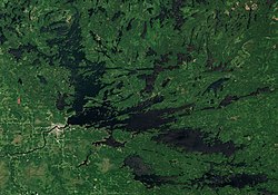
Rainy Lake (French: lac à la Pluie; Ojibwe: gojiji-zaaga'igan) is a freshwater lake with a surface area of 360 square miles (932 km2) that straddles the border between the United States and Canada. The Rainy River issues from the west side of the lake. Today it is harnessed to make hydroelectricity for US and Canadian locations. International Falls, Minnesota and the much smaller city of Ranier, Minnesota are situated opposite Fort Frances, Ontario, on either side of the Rainy River. Rainy Lake and Rainy River establish part of the boundary between the US state of Minnesota and the Canadian province of Ontario.[2]
Voyageurs National Park is located on the southeastern corner of the lake, where it connects with Kabetogama and Namakan lakes at Kettle Falls. Rainy Lake is part of an extremely large system of lakes forming the Hudson Bay drainage basin that stretches from west of Lake Superior north to the Arctic Ocean. The Rainy Lake watershed includes the Boundary Waters Canoe Area Wilderness (BWCA), portions of the Superior National Forest on the US side of the border, and the Quetico Provincial Park on the Canadian side of the border.[3]
For exploration and fur trade history, see Winnipeg River and additional references below.[4][5]
^Rahm, Joe. Island Images: Rainy Lake’s missing islands. The Journal. 14 Feb. 2010.
^Geographical Place Names of Voyageurs National Park(PDF), 2008, retrieved 2013-07-25
^"Rapid Watershed Assessment: Rainy Lake" (PDF). Natural Resources Conservation Service, United States Department of Agriculture. Archived from the original (PDF) on 2022-10-06. Retrieved 2017-07-16.
^
Douglas A. Birk; Jeffrey J. Richner (2004), From Things Left Behind: Fur Trade Sites and Artifacts, Voyageurs National Park and Environs, 2001-2002, Midwest Archeological Center and Institute for Minnesota Archaeology, MAC Technical Report Number 84, IMA Reports of Investigation Number 606, retrieved 2017-07-16
^Ted Catton; Marcia Montgomery, Special History: The Environment and the Fur Trade Experience in Voyageurs National Park, 1730-1870, retrieved 2017-07-16
RainyLake (French: lac à la Pluie; Ojibwe: gojiji-zaaga'igan) is a freshwater lake with a surface area of 360 square miles (932 km2) that straddles the...
major lakes: RainyLake - 60 miles (97 km) long, 929 miles (1,495 km) of shoreline, 227,604 acres (921.1 km2), 161 feet (49 m) max depth Kabetogama Lake -...
16A Lake of the Woods 31H Lake of the Woods 34 Long Sault 12 Manitou Rapids 11 Naongashing 31A Neguaguon Lake 25D RainyLake 17A RainyLake 17B Rainy Lake...
RainyLake Falls is a waterfall on the inlet stream of namesake RainyLake in Chelan County, Washington. The stream heads in a pair of small lakes and...
Saulteaux, better known as the Ontario Saulteaux, are located around RainyLake and Lake of the Woods in Northwestern Ontario and southeastern Manitoba. Many...
RainyLake 18C is a First Nations reserve on RainyLake in Rainy River District, Ontario. It is the main reserve of the Mitaanjigamiing First Nation. "Rainy...
on the international border with the United States where RainyLake narrows to become Rainy River, it is connected to International Falls, Minnesota by...
Band of Chippewa Lake Vermilion Band of Lake Superior Chippewa Little Forks Band of Rainy River Saulteaux Fond du Lac Band of Lake Superior Chippewa...
Holden LakeLake Huron Horseshoe Lake multiple lakes Inn Lake Indian Lake Innis Lake Irwin Lake Ivanhoe Lake Jack Lake Jeff LakeLake Joseph Jules Lake Jumping...
RainyLake 26A is a First Nations reserve on RainyLake in Rainy River District, Ontario, Canada. It is the main reserve of the Nigigoonsiminikaaning First...
RainyLake 26B is a First Nations reserve in Rainy River District, Ontario, Canada. It is one of the reserves of the Nigigoonsiminikaaning First Nation...
following is a list of the 100 largest lakes of the United States by normal surface area. The top twenty lakes in size are as listed by the National Atlas...
This section covers the route from Lake Superior to Lake Winnipeg via RainyLake, the Rainy River, Lake of the Woods and the Winnipeg River. For the route...
Lake, the Red River (including Assiniboine River) flows in from the south, and the Winnipeg River (draining Lake of the Woods, Rainy River and Rainy Lake)...
RainyLake 26C is a First Nations reserve in Rainy River District, Ontario, Canada. It is one of the reserves of the Nigigoonsiminikaaning First Nation...
Michigan Lake Memphremagog in Quebec and Vermont Lake Ontario in Ontario and New York Osoyoos Lake in British Columbia and Washington RainyLake in Ontario...
lakes Manitoba and Winnipegosis. In northern Minnesota, there are Roseau, Thief, Mud, and Maple lakes, besides three large lakes of that state, Rainy...
RainyLake and River Bands of Saulteaux (Ojibwe language: Gojijiwininiwag) are Saulteaux (Ojibwe) group located in Northwestern Ontario and northern Minnesota...
 Global Information