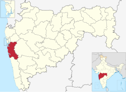
Raigad district (Marathi pronunciation: [ɾaːjɡəɖ]), previously Colaba district, is a district in the Konkan division of Maharashtra, India.[2]
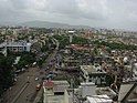
The headquarters of the district is Alibag. Other major cities in the district are Panvel, Karjat, Navi Mumbai, Khopoli, Shrivardhan and Mahad.
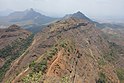
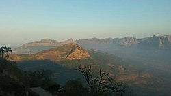
The district was renamed to Raigad after the fort that was the first capital of the former Maratha Empire, which in turn was renamed from its earlier name - Rairi. The fort is located in the interior regions of the district, in dense forests on a west-facing spur of the Western Ghats of Sahyadri Range. In 2011 the district had a population of 2,634,200, compared to 2,207,929 in 2001. The name was changed in the regime of Chief Minister A. R. Antulay on 1 January 1981.[3] In 2011 urban dwellers had increased to 36.91% from 24.22% in 2001.[4] Alibag is the headquarters of Raigad district.[5]
Raigad district's neighbouring districts are Mumbai, Thane districts on North, Pune district on East, Satara district on South East, Ratnagiri district is present on South side and Arabian sea on West.[6]
^"Election Commission website" (PDF). Archived from the original (PDF) on 6 March 2009. Retrieved 14 April 2009.
^"List of districts in Maharashtra". districts.nic.in. Retrieved 19 November 2012.
^"रायगड जिल्हा". Archived from the original on 6 October 2021. Retrieved 15 December 2017.
^"Raigarh District Population 2011". Census Organisation of India.
^"District Map". Government of Maharashtra. Retrieved 7 January 2021.
^Sawadi, A.B. (2020). महाराष्ट्राचा भूगोल (in Marathi). Pune, India: Nirali publication. p. 8.
Raigaddistrict (Marathi pronunciation: [ɾaːjɡəɖ]), previously Colaba district, is a district in the Konkan division of Maharashtra, India. The headquarters...
Raigad, situated in the Raigaddistrict of Maharashtra, India, is a hill fort located in the town of Mahad. It is one of the strongest fortresses on the...
Raigad Lok Sabha constituency is one of the 48 Lok Sabha (lower house of Indian parliament) constituencies of Maharashtra state in western India. It is...
Raigad may refer to: Raigaddistrict in Maharashtra, India Raigad fort Raigad (Lok Sabha constituency) in Maharashtra, India Raigarh, district in Chhattisgarh...
Zilla Parishad Raigad or District Council Raigad is a district council having jurisdiction over Raigaddistrict in Maharashtra, India. Currently there...
Mahad (pronunciation [məɦaːɖ]) is a city in Raigaddistrict (formerly Kulaba district) situated in the North Konkan region of Maharashtra state, India...
history of Raigaddistrict. RaigadDistrict is a district in the Indian state of Maharashtra. It is located in the Konkan region. The Kulaba district was renamed...
Palghar district to the north. The Arabian Sea forms the western boundary, while it is bounded by Mumbai Suburban district to the south west, and Raigad District...
the Ratnagiri district. The erstwhile Kolaba district was renamed as Raigad. In 2014, Palghar district was carved out of Thane district with the inclusion...
segments. These segments are: Khed Lok Sabha constituency Pune districtRaigaddistrict List of constituencies of the Lok Sabha "Delimitation Commission...
Tourism Development Corporation Services Preparatory Institute Oshiwara District Centre Maharashtra Police Maharashtra State Commission for Woman Maharashtra...
city and a municipal council in Raigaddistrict of Maharashtra, India. It is the headquarters of the Raigaddistrict and is south of the city of Mumbai...
Vidhan Sabha constituencies located in the Raigaddistrict. and comprises a part of Panvel tehsil of the district. Panvel is part of the Maval Lok Sabha constituency...
(Pronunciation: [kəɾd͡zət̪]) is a city administered under a Municipal Council in Raigaddistrict in the Indian state of Maharashtra. It is served by Karjat railway...
Ganesha in and around Pune and RaigadDistrict of Maharashtra. Out of these 8 Temples, 6 are in Pune and 2 are in RaigadDistrict. Ganesha is worshiped first...
Member of the Legislative Council of Maharashtra. He is Chairman of RaigadDistrict Central Co-operative Bank. After the death of his father he became...
Khalapur taluka is a taluka in Raigaddistrict of Maharashtra. The headquarters of the taluka is Khalapur village. This taluka belongs to the Karjat sub-division...
Ratnagiri. The district is 11.33% urban. The district is bounded by the Arabian Sea to the west, Sindhudurg district to the south, Raigaddistrict to the north...
Panvel (Marathi pronunciation: [pənʋeːl]) is a city and taluka in Raigaddistrict of Maharashtra, India. It is highly populated due to its closeness to...
constituencies: Chinchwad and Maval from Pune District and Karjat, Uran and Panvel from the Raigaddistrict. "Delimitation of Parliamentary and Assembly...
Khalapur is a town and tehsil in Raigaddistrict, Maharashtra state of India. "Khalapur Map | India Google Satellite Maps". maplandia.com. Retrieved 18...
19 July 2023 at approximately 22:30 local time, a landslide occurred in Raigad, Maharashtra, India. The landslide was caused by torrential rains, and resulted...
constituencies: Pimpri and Maval from the Pune District and Karjat, Uran and Panvel from the Raigaddistrict. The last Legislator representing this constituency...
constituencies: Pimpri and Chinchwad from the Pune District and Karjat, Uran and Panvel from the Raigaddistrict. Maval "Delimitation of Parliamentary and Assembly...
it is located on the eastern shores of Arabian Sea in Navi Mumbai, Raigaddistrict, Maharashtra. This port can be accessed via Thane Creek, a nodal city...
 Global Information