Maine Department of Agriculture, Conservation and Forestry
Website
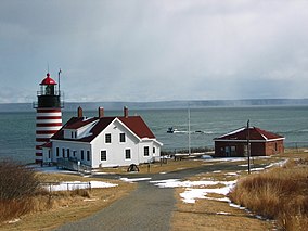
Quoddy Head State Park
Quoddy Head State Park is a public recreation area in Lubec, Maine, located on the easternmost point of land in the continental United States. On its 541 acres (219 ha), purchased by the state in 1962, the state park features 5 miles (8 km) of hiking trails, extensive forests, two bogs, diverse habitat for rare plants, and the striking, red-and-white striped lighthouse tower of West Quoddy Head Light.[3]
In 1808, West Quoddy Head Light became the easternmost lighthouse in the United States. Its light and fog cannon warned mariners of Quoddy's dangerous cliffs, ledges, and Sail Rock. Among the first to use a fog bell and later a steam-powered foghorn, this lighthouse greatly reduced shipwrecks in this foggy area, even as shipping increased. In 1858, the present red-and-white tower replaced the original. Monitored and serviced by the United States Coast Guard, its light still shines through its original third-order Fresnel lens. After automation in 1988, the light station became part of adjacent Quoddy Head State Park. A visitor center and museum in the former light keeper's quarters are run by the West Quoddy Head Light Keepers Association.[4] The tower is closed to visitors.
For a few weeks around the equinoxes, West Quoddy Head is the first location in the United States to see the sunrise.[5] Quoddy Head State Park is also the closest geographic point in the United States to the African continent.[6]
^ ab"West Quoddy Head". Geographic Names Information System. United States Geological Survey, United States Department of the Interior.
^Cite error: The named reference dacf2 was invoked but never defined (see the help page).
^ abCite error: The named reference dacf was invoked but never defined (see the help page).
^Cite error: The named reference keepers was invoked but never defined (see the help page).
^"Katahdin, Maine". Peakbagger.com. Retrieved October 16, 2010. Analysis by Blanton C. Wiggin, published in the January 1972 issue of Yankee Magazine.
^Cite error: The named reference closest was invoked but never defined (see the help page).
and 27 Related for: Quoddy Head State Park information
QuoddyHeadStatePark is a public recreation area in Lubec, Maine, located on the easternmost point of land in the continental United States. On its 541...
West QuoddyHead, in QuoddyHeadStatePark, Lubec, Maine, is the easternmost point of the contiguous United States. In 1808 a lighthouse was constructed...
Quoddy can mean the following places: Canada East Quoddy, Nova Scotia West Quoddy, Nova Scotia United States QuoddyHeadStatePark in Maine West Quoddy...
Head Harbour Lighthouse, also known as East QuoddyHead Light (mostly by Americans to differentiate the Canadian beacon from its American counterpart...
This list includes 35 stateparks, public reserved lands, and state historic sites in the U.S. state of Maine. They are operated by the Maine Department...
Border." The call sign stands for Calais Radio Quoddy, with the Q representing QuoddyHeadStatePark, a local attraction. Under proper weather conditions...
acrobatic moves "stunts", and therefore unworthy of recognition, Goodwin stated he was "sport climbing" and not bound by the rules of traditional rock climbing...
West Quoddy Lifesaving Station is a historic coastal rescue station on West QuoddyHead in Lubec, Maine. The lifesaving station was built in 1919, and...
Lubec is the easternmost organized settlement in the United States. Its QuoddyHead Lighthouse is also the closest place in the United States to Africa and...
Portland Head Light is a historic lighthouse in Cape Elizabeth, Maine. The light station sits on a head of land at the entrance of the primary shipping...
(2.4 km); Searsport Calais Walkway, 1.5 miles (2.4 km), Calais QuoddyHeadStatePark, 5.5 miles (8.9 km) Lubec Alewive Woods Preserve, 2.4 miles (3.9 km);...
the 50 states West QuoddyHead, Maine 44°48′55.4″N 66°56′59.2″W / 44.815389°N 66.949778°W / 44.815389; -66.949778 (West QuoddyHead) – easternmost point...
activities in the park include viewing the lighthouse, picnicking, and viewing local paintings at the Pemaquid Art Gallery. A State Historic Site exists...
6. For a few weeks around the equinoxes, the sun rises first at West QuoddyHead in Lubec, Maine. During the remainder of spring and throughout summer...
was part of the aborted Passamaquoddy Bay Tidal Power Project (a.k.a., Quoddy Dam Project) to generate electricity from its large tidal range. Cobscook...
3 ha) Owls HeadStatePark and was added to the National Register of Historic Places as Owls Head Light Station in 1978. The town of Owls Head is located...
Government The facility is adjacent to Two Lights StatePark, a 41-acre (17 ha) state facility. However, the park no longer has view of the lighthouses, and...
Register Information System". National Register of Historic Places. National Park Service. March 13, 2009. "Historic Light Station Information and Photography:...
Maine with a population of 1,600 people. The race ended on day 4 at West QuoddyHead Lighthouse where the team with the highest sales were given $50,000 and...
frequented by whales potentially and might be re-colonized in the future such as Quoddy, Eastport, Plymouth Harbor, Sagamore Beach, Island of Nantucket, Florida...
1943 on Rendova Island. The Seabees named their Naval Training Center at Quoddy Village Eastport, Maine, Camp Lee-Stephenson in honor of them. The first...
the Eastern-most point of the continental United States at the West QuoddyHead light in Lubec, Maine. He reached the Atlantic Ocean in South Carolina...
commissioned that August. Other CB Camps were Camp Parks, Livermore, Ca., and Camp Lee-Stephenson, Quoddy Village, Eastport, Maine and Camp Holliday, Gulfport...
Register Information System". National Register of Historic Places. National Park Service. March 13, 2009. Anderson, Amy (22 July 2010). "Ram Island Ledge...
States state of Maine. The monument, a pyramidal stone structure built in 1827, is one of only three such structures ever built in the state, and is...
68111°W / 18.91083; -155.68111) East: Sail Rock, just offshore West QuoddyHead, Maine 44°48′54″N 66°56′52″W / 44.81500°N 66.94778°W / 44.81500; -66...
 Global Information