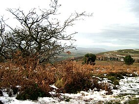
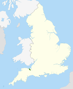
The Quantock Hills west of Bridgwater in Somerset, England, consist of heathland, oak woodlands, ancient parklands and agricultural land. They were England's first Area of Outstanding Natural Beauty, designated in 1956.[1]
Natural England have designated the Quantock Hills as a national character area. They are entirely surrounded by another: the Vale of Taunton and Quantock Fringes.[2]
The hills run from the Vale of Taunton Deane in the south, for about 15 miles (24 km) to the north-west, ending at Kilve and West Quantoxhead on the coast of the Bristol Channel. They form the western border of Sedgemoor and the Somerset Levels. From the top of the hills on a clear day, it is possible to see Glastonbury Tor and the Mendips to the east, Wales as far as the Gower Peninsula to the north, the Brendon Hills and Exmoor to the west, and the Blackdown Hills to the south. The highest point on the Quantocks is Wills Neck, at 1,261 feet (384 m).[3] Soil types and weather combine to support the hills' plants and animals. In 1970, an area of 6,194.5 acres (2,506.8 ha) was designated as a Biological Site of Special Scientific Interest.[4]
Archaeological landscape features include Bronze Age round barrows, extensive ancient field systems and Iron Age hill forts. Roman silver coins have been discovered in West Bagborough. The hills are popular with walkers, mountain bikers, horse riders and tourists who explore paths such as the Coleridge Way.
^"Quantock Hills AONB Service Website". Quantock Hills AONB. Somerset County Council. Archived from the original on 7 February 2012. Retrieved 18 April 2011.
^NCA 146: Vale of Taunton & Quantock Fringes Key Facts & Data at www.naturalengland.org.uk. Retrieved 4 October 2013
^Leete-Hodge, Lornie (1985). Curiosities of Somerset. Bodmin: Bossiney Books. p. 41. ISBN 0-906456-98-3.
^"The Quantocks" (PDF). English Nature. Retrieved 24 January 2007.
The QuantockHills west of Bridgwater in Somerset, England, consist of heathland, oak woodlands, ancient parklands and agricultural land. They were England's...
all of the Mendip Hills, which are both national landscapes; the west contains the QuantockHills and part of the Blackdown Hills, which are also national...
number of other groups of hills are also present in the area: the QuantockHills (Will's Neck: 384 m [1,260 ft]), Blackdown Hills, Dorset Downs, Salisbury...
Quantock may mean: "Quantocking" and "Quantocking II", two episodes of Peep Show about visiting the QuantockHillsQuantock Lodge, a mansion in Somerset...
see across Somerset to the Blackdown Hills, QuantockHills and Brendon Hills. There are ancient remains on the hill, in the form of a neolithic Long barrow...
environment of the QuantockHills”. They are an independent charity, funded and governed by their own membership as “guardians of the QuantockHills on behalf...
rail and Tube station Seven Sisters Road, North London Seven Sisters (QuantockHills), a prominent Somerset landmark Seven Sisters Road, St Lawrence, Isle...
of West Bagborough lies on the south-west slopes of the QuantockHills within the QuantockHills A.O.N.B and encompasses the neighbouring hamlets of Shopnoller...
extends between the QuantockHills and the Brendon Hills on the eastern edge of Exmoor and, to the east, between the QuantockHills and the Somerset Levels...
River Exe. The hills are quite heavily cultivated unlike their neighbouring upland areas of Exmoor and the QuantockHills. The Brendon Hills are largely...
Wills Neck is the highest summit on the QuantockHills and one of the highest points in Somerset, England. Although only 1261 ft (384 m) high, it qualifies...
The main upland areas are the Mendip Hills in the east and the QuantockHills further west, the Blackdown Hills form the county's southern border, and...
village in Somerset, South West England. It sits in the foothills of the QuantockHills (England's first Area of Outstanding Natural Beauty), just below Over...
Woman's Ditch," which is part of an Iron Age camp at Dowsborough in the Quantockhills In the dark red mud, police also found gold jewellery and buttons from...
Mendip Hills North Devon Coast North Wessex Downs QuantockHills South Devon Tamar Valley Wye Valley3 West Midlands Cannock Chase Cotswolds Malvern Hills Shropshire...
and Wordsworth's sister Dorothy were on a walking tour through the QuantockHills in Somerset. The discussion had turned to a book that Wordsworth was...
Crowcombe is a village and civil parish under the QuantockHills in Somerset, England, 5.5 miles (9 km) southeast of Watchet, and 8 miles (13 km) from...
House is a historic country house in the parish of West Monkton in the QuantockHills, near Taunton in Somerset, England. The house is a Grade II* listed...
suggested from Stolford to Bridport which would have passed through the QuantockHills near Crowcombe. Alternatively, the Bridgwater and Minehead Junction...
The Quantock Greenway is a footpath in the QuantockHills in Somerset, England, which opened in 2001. The route of the path follows a figure of 8 centred...
the QuantockHills, which in 1956 became the first Area of Outstanding Natural Beauty created in the UK. Large areas of Exmoor and the QuantockHills are...
Holford is a village and civil parish in West Somerset within the QuantockHills Area of Outstanding Natural Beauty. It is located about 10 miles (16 km)...
estate of 'Over and Nether Stowey' or just the 'Quantock' estate, named after the nearby QuantockHills. Lord Taunton was then the MP for nearby Taunton...
Purbeck Hills. These downs are the principal area of arable agriculture in the region. Limestone is also found in the region, at the Cotswolds, Quantock Hills...
 Global Information