This article is about the freeway in Victoria. For the motorway in Sydney, see Princes Motorway. For the freeway as a whole (except as stated below), see Princes Highway. For other uses, see Princes Highway (disambiguation).
This article is about the actual freeway that serves the respective parts of Victoria and not in between. For the freeway that serves southeastern Melbourne, see Monash Freeway. For the freeway east of the western section, see West Gate Freeway.
Princes Freeway
Victoria
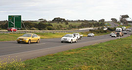
Princes Freeway at Lara
General information
Type
Freeway
Length
159 km (99 mi)[1][2]
Route number(s)
(1997–present)
Former route number
National Route 1 (1955–1997)
Tourist routes
Tourist Route 21 (Corio–Altona North)
Major junctions
Princes Freeway (West)
Southwest end
Geelong Ring Road Corio, Geelong
Princes Highway
Shell Parade
Geelong Road
Duncans Road
Princes Highway
Old Geelong Road
Forsyth Road
Palmers Road
Central Avenue
Old Geelong Road
Kororoit Creek Road
Western Ring Road
Geelong Road
Northeast end
West Gate Freeway Laverton North, Melbourne
Princes Freeway (East)
West end
Monash Freeway Narre Warren, Melbourne
Princes Highway
Clyde Road
O'Shea Road
Cardinia Road
Koo Wee Rup Road
Nar Nar Goon Connection Road
Sand Road
Princes Way
Princes Drive
Strzelecki Highway
East end
Princes Highway Morwell, Victoria
Location(s)
Major suburbs / towns
Geelong, Little River, Werribee, Laverton, Drouin, Warragul, Moe, Morwell
Highway system
Highways in Australia
National Highway • Freeways in Australia
Highways in Victoria
----
Infobox instructions
guidelines
examples
talk
Princes Freeway is a 159-kilometre (99 mi) Australian freeway, divided into two sections, both located in Victoria, Australia. The freeway links Melbourne to Geelong in the west, and to Morwell in the east. It continues beyond these extremities as the Princes Highway towards Adelaide to the west and Sydney to the northeast. The freeway bears the designation M1.
The western section linking Geelong and Melbourne is an important commuter, freight and tourism route between the two cities; the eastern section links Melbourne with the Latrobe Valley and major business suburbs, namely Dandenong and Berwick. The entire freeway is one of the busiest sections of rural highway in Victoria, used by large numbers of freight and commercial vehicles and provides access to tourist attractions in central and east Gippsland. It supports Victoria's rural industries and tourism.
^Google (6 June 2022). "Princes Freeway (west)" (Map). Google Maps. Google. Retrieved 6 June 2022.
^Google (6 June 2022). "Princes Freeway (east)" (Map). Google Maps. Google. Retrieved 6 June 2022.
PrincesFreeway is a 159-kilometre (99 mi) Australian freeway, divided into two sections, both located in Victoria, Australia. The freeway links Melbourne...
two stages of PrincesFreeway are taken up by either a series of unrelatedly named motorways namely Monash Freeway, or largely by Princes Highway. Within...
Chadstone to the Princes Highway in Eumemmerring; and the South Eastern Freeway (initially designated Metropolitan Route 80, then Freeway Route 80) linking...
freeway after the Hume Freeway. It is 159 kilometres long. It continues on from the Princes Highway at Tralagon and ends at the Princes Highway at Geelong...
carrying upwards of 200,000 vehicles per day. It links Geelong (via the PrincesFreeway) and Melbourne's western suburbs to central Melbourne and beyond. It...
urban and rural freeways (the West Gate and PrincesFreeways, Western Freeway, Calder Freeway, Tullamarine Freeway and Hume Freeway), and also relieves...
Outer Freeway, officially part of PrincesFreeway West) is a freeway ring road in Australia beside Geelong's western suburbs from the PrincesFreeway at...
the West Gate Freeway, Western Ring Road and PrincesFreeway lies in the north-west of Hobsons Bay. From Hobsons Bay, the West Gate Freeway provides access...
Road is a proposed freeway in Melbourne, Australia connecting the Hume Freeway at Kalkallo north of Melbourne, to the PrincesFreeway south-west of Werribee...
Highway and Princes Highway have some of the heaviest traffic in Australia. Many of the highways are built to freeway standard ("M" freeways), while most...
route M1, and Southern Freeway and Mount Ousley Road were officially renamed as M1 Princes Motorway. At the southern end, Princes Motorway was extended...
next to the Williams Landing railway station, just across from the PrincesFreeway and for residents of Point Cook, it is accessed via Palmers Road. Construction...
Chadstone and Princes Highway at Eumemmerring. The freeway began as an overflow from construction of Mulgrave Freeway (now Monash Freeway) in 1970, where...
new interchange opened on 15 August 2016. The Freeway bypasses many towns previously along the Princes Highway, including: Eagle On The Hill Crafers Stirling...
to the Dingley Freeway corridor. The main alternative route between Sydney and Melbourne is the Princes Highway/PrincesFreeway/Princes Motorway route...
interchange with West Gate Freeway in Port Melbourne. At the same time, VicRoads also re-declared the West Gate Freeway to terminate at Princes Highway East (today...
Avalon Airport is linked to Geelong and Melbourne by the adjacent PrincesFreeway. The airport has 1,500 airport car spaces, a taxi rank and a ride-share...
 Global Information