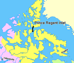
Prince Regent Inlet (73°00′N090°30′W / 73.000°N 90.500°W / 73.000; -90.500 (Prince Regent Inlet)) is a body of water in Nunavut, Canada between the west end of Baffin Island (Brodeur Peninsula) and Somerset Island on the west. It opens north into Lancaster Sound and to the south merges into the Gulf of Boothia. The Arctic inlet's northern portion is approximately 40 mi (64 km) wide; the southern portion is approximately 65 mi (105 km) wide. It is deep throughout and there are no islands within the inlet.[1]
During the quest for the Northwest Passage it was entered several times until it was realized that Prince Regent Inlet-Gulf of Boothia is a cul-de-sac for practical purposes. In 1819 William Edward Parry penetrated more than 100 miles south before turning back. In 1829 John Ross passed through it and was frozen in the Gulf of Boothia for four years before escaping. In 1852 Bellot Strait, the frozen western exit, was discovered. In 1858 Francis Leopold McClintock tried to pass this strait, gave up, and wintered near its mouth.
^Donat Pharand (1984). The Northwest Passage: Arctic Straits. Martinus Nijhoff Publishers. ISBN 9789024729791. Retrieved 2008-01-18.
and 23 Related for: Prince Regent Inlet information
PrinceRegentInlet (73°00′N 090°30′W / 73.000°N 90.500°W / 73.000; -90.500 (PrinceRegentInlet)) is a body of water in Nunavut, Canada between the...
heavy ice, they went south for more than 100 miles (160 km) into PrinceRegentInlet before turning back. Continuing west they passed 110° W (about 600...
west and the Qikiqtaaluk Region on the east. It merges north into PrinceRegentInlet, the two forming a single bay with different names for its parts...
and 25-kilometre-long (16 mi) strait connects the Gulf of Boothia, PrinceRegentInlet, and Brentford Bay to its east with Peel Sound and Franklin Strait...
part of the island and is bounded by PrinceRegentInlet to the west, Lancaster Sound to the north, and Admiralty Inlet to the east. The peninsula is connected...
Nunavut, Canada. It faces PrinceRegentInlet at the northeast tip of Somerset Island. Elwin Baymap is to the south, while Prince Leopold Islandmap is to...
Nunavut, Canada. It is located in Lancaster Sound at the junction of PrinceRegentInlet and Barrow Strait. Somerset Island is situated 13 km (8.1 mi) to...
Strait, north to Lancaster Sound through the Gulf of Boothia and PrinceRegentInlet. The Fury and Hecla Strait is usually closed by ice. Centre: Canadian...
Green Bay and Lake Michigan Prince of Wales Strait – between Banks Island and Victoria Island in Canada PrinceRegentInlet – between the west end of Baffin...
Strait and Kapuiviit and Gifford Fiord, and into Gulf of Boothia and PrinceRegentInlet. Northward migrating along western Foxe Basin to eastern side of...
Arctic waterway in Qikiqtaaluk Region, Nunavut, Canada. It is located PrinceRegentInlet by the northeastern shore of Somerset Island. Port Leopold is nearby...
Prince Leopold Island within Lancaster Sound at the junction of PrinceRegentInlet and Barrow Strait. It was established in 1992 and is classified Category...
Aulacogen is a geological structure underlying Lancaster Sound and PrinceRegentInlet in the Arctic Archipelago of Nunavut, Canada. It formed as a result...
the wall: "Erebus and Terror, Sir John Franklin, Lancaster Sound, PrinceRegentInlet, Point Victory, Victoria Channel". Coppin appeared to all of her...
Ross's 1829 Arctic expedition failed and was dumped on the shores of PrinceRegentInlet. At this stage of Ericsson's career the most successful and enduring...
 Global Information