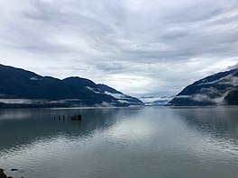
Portland Canal[1] is an arm of Portland Inlet, one of the principal inlets of the British Columbia Coast. It is approximately 114 km (71 mi) long.[2] The Portland Canal forms part of the border between southeastern Alaska and British Columbia. The name of the entire inlet in the Nisga'a language is Kʼalii Xkʼalaan, with xkʼalaan meaning "at the back of (someplace)". The upper end of the inlet was home to the Tsetsaut (Jitsʼaawit in Nisgaʼa), who after being decimated by war and disease were taken under the protection of the Laxsgiik (Eagle) chief of the Nisga'a, who holds the inlet's title in native law.[3][4]
Despite its naming as a canal, the inlet is a fjord, a completely natural and not man-made geographic feature, and extends 114.6 km (71.2 mi) northward from the Portland Inlet at Pearse Island, British Columbia, to Stewart, British Columbia and Hyder, Alaska. Observatory Inlet joins the Portland Canal at Ramsden Point, where both merge with Portland Inlet.[5] Pearse Canal joins Portland Canal at the north end of Pearse Island.[6]
Portland Canal was given its name by George Vancouver in 1793, in honour of William Cavendish-Bentinck, 3rd Duke of Portland.[4] The use of the word canal to name inlets on the British Columbia Coast and the Alaska Panhandle is a legacy of the Spanish exploration of the area in the 18th century. For example, Haro Strait between Victoria and the San Juan Islands was originally Canal de Haro. The English cognate to the Spanish canal is "channel", which is found throughout the coast, cf. Dean Channel. George Vancouver used both terms in his naming of inlets, Hood Canal for example.
The placement of the international boundary in the Portland Canal was a major issue during the negotiations over the Alaska boundary dispute, which heated up as a result of the Klondike Gold Rush and ended by arbitration in 1903. Together with Pearse Canal and Tongass Passage, the Portland Canal is defined by the Alaska Boundary Settlement (the Hay-Herbert Treaty) as part of Portland Channel (Canal),[7] a term used as forming the marine boundary in the Anglo-Russian Treaty of 1825 but which was undefined at the time.
PortlandCanal is an arm of Portland Inlet, one of the principal inlets of the British Columbia Coast. It is approximately 114 km (71 mi) long. The Portland...
The Louisville and PortlandCanal was a 2-mile (3.2 km) canal bypassing the Falls of the Ohio River at Louisville, Kentucky. The Falls form the only barrier...
Alaska and British Columbia PortlandCanal, an arm of Portland Inlet Portland Estates, Nova Scotia, an area of Halifax Portland, Ontario, a town north of...
Power Canal Washington Canal American Canal Franklin Canal Riverside Canal (El Paso) (Texas) Texas Irrigation Canals Lynn Canal and PortlandCanal in Alaska...
by a wide variety of craft then in use. In 1830, the Louisville and PortlandCanal (now the McAlpine Locks and Dam) bypassed the rapids, allowing even...
Parrish, Charles E. (2007). Triumph at the Falls: The Louisville and PortlandCanal. Louisville: U.S. Army Corps of Engineers. p. 42. Archived from the...
attempts, and possible sabotage by a supporter of the Louisville and PortlandCanal, the project was ended. As the Midwestern United States became populated...
for "sound"). Some fjord-type inlets are called canals, e.g., PortlandCanal, Lynn Canal, Hood Canal, and some are channels, e.g., Dean Channel and Douglas...
Seaplane Base. While its neighbouring seaplane bases' water runways in the PortlandCanal exist on the Canada–United States border, the aerodrome's runway exists...
northward extension of Portland Inlet, other branches of which include the PortlandCanal. The entrance of Observatory Inlet, from Portland Inlet, lies between...
SJ933984) is the name of the canal junction where the Peak Forest Canal, the Ashton Canal and the Huddersfield Narrow Canal meet near Ashton-under-Lyne...
Athabaskan-speaking group whose territory was around the head of the PortlandCanal, straddling what is now the boundary between the US state of Alaska...
first locks on the river, the Louisville and PortlandCanal completed in 1830, were built within a bypass canal constructed to provide year-round navigation...
Island Salmon River (Langley), in the Lower Fraser Valley Salmon River (PortlandCanal), in northwestern British Columbia Salmon River (Shuswap Lake), near...
(British Columbia), a river in British Columbia, entering the head of the PortlandCanal at the community of Stewart Bear River (Sustut River), a river in the...
4 km (2.5 mi) long and as much as 13 km (8.1 mi) wide. It drains the PortlandCanal, Nass Bay (outlet of the Nass River), and Khutzeymateen Inlet, among...
United States: Lynn Canal, Glacier Bay, etc. British Columbia Coast, Canada: from the Alaskan Border along the PortlandCanal to Indian Arm; Kingcome...
Columbia. Another group in this region, the Tsetsaut people, lived in the PortlandCanal area of the northernmost BC Coast near the border with Alaska. They...
 Global Information