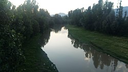
The Pohru River (Urdu: پہرو) is a right tributary of Jhelum River that flows through the Kupwara and Baramulla district of Kashmir region. Pohru river is formed by joining of Khamil Nallah and Lolab Nallah in the Kupwara town. Khamil Nallah originates from Shamashabri mountains in the Bangus valley and is joined by Budnamal Nallah at Chowkibal. Lolab Nallah is formed by confluence of several streams like Khurhama stream, Kalarose stream, Gund Machar stream etc. Mawer River is the main tributary of Pohru river, it originates from Kazinag Mountains and joins Pohru river at Ujroo Village of Langate tehsil. Pohru river passes through many villages where it finally enters into the jehum river near Doabgah [1] sopore town Baramullah district [2][3] Pohru River is one of the tributaries of the river Jhelum.[4]
^"Google Maps". Google Maps. Retrieved 2024-02-12.
^"Pohru River, Jammu And Kashmir, India - GeoYP.com". Retrieved 2021-05-09.
^Central Ground Water Board. "District Profile Kupwara". Retrieved 10 May 2021.
^Qazi, S. A. (2005). Systematic Geography of Jammu and Kashmir. APH Publishing. ISBN 978-81-7648-786-3.
The PohruRiver (Urdu: پہرو) is a right tributary of Jhelum River that flows through the Kupwara and Baramulla district of Kashmir region. Pohruriver is...
River Tawi River Ravi River (in India and Pakistan) Budhil River Siul River Jhelum River (in India and Pakistan) Lidder River Sind RiverPohruRiver Kishanganga...
tributaries Lidder River near village Mirgund at Khanabal Veshaw River at Sangam in Anantnag Sind River at Shadipora PohruRiver at Doabgah in Sopore...
form one of the headwaters of the Kamil River which in turn joins the Lolab stream, thus forming the PohruRiver. Bangus is replete with a diverse variety...
administered Kashmir. The PohruRiver (originating in Lolab Valley and flowing from east to west) and Mawar river are two main rivers in the district. Both...
village has been named so as two prominent rivers of Kashmir meet here, namely PohruRiver and Jhelum River. Doabgah was given backward status in 2012...
Srinagar-Kupwara national highway and is located on the banks of the PohruRiver. Seeloo is made up of the mohallas, Al-umar, Salfia Colony, Sidiq Colony...
the Wular lake and the Pohruriver developed by Zain-ul-Abidin (1420-1470 A.D.) by raising a dam of boulders across the Pohru to provide water for irrigation...
Satkohl Nag which have been providing water to the Kehmil, Pohru, Mawar and Talar rivers nearby, and some of the water goes to Pakistan through Nowkote...
century), Zaloora got its importance. He turned the direction of the riverPohru through Zaloora in order to serve water scarcity in Zaingair. In recent...
 Global Information