Nong Bua Lamphu Udon Thani Sakon Nakhon Nakhon Phanom Kalasin Roi Et Maha Sarakham Mukdahan
Geology
Age of rock
Early Cretaceous
Type of rock
Sandstone and siltstone
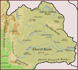
The Phu Phan mountains (Thai: ทิวเขาภูพาน, RTGS: Thio Khao Phu Phan, pronounced[tʰīwkʰǎwpʰūːpʰāːn]) are a range of hills dividing the Khorat Plateau of the Isan region of Thailand into two basins: the northern Sakhon Nakhon Basin, and the southern Khorat Basin.[1]
The silhouette of the Phu Phan Mountains appears in the provincial seal of Kalasin since they form the northern boundary of the province.[2]
The Phu Phan mountains are among the places in Thailand more severely affected by the Illegal logging of Phayung (Siamese Rosewood) trees. Although officially a protected tree, the cutting and trading of the endangered rosewood trees has been going unabated in Thailand's mountainous forested zones, even in the protected areas. In Thailand and in China this wood is highly valued in the furniture industry.[3][4]
^Schuler, Ulrich. "NE-Thailand (Isan)". Geosciences. Retrieved 23 July 2017.
^Seals of The Provinces of Thailand
^Fredrickson, Terry (2011-09-19). "Forest robbery". Bangkok Post. Retrieved 10 November 2015.
^Waewkraihong, Jakkrit (6 Feb 2013). "Cambodians caught for phayung smuggling". Bangkok Post. Retrieved 10 November 2015.
and 23 Related for: Phu Phan Mountains information
The PhuPhanmountains (Thai: ทิวเขาภูพาน, RTGS: Thio Khao PhuPhan, pronounced [tʰīw kʰǎw pʰūːpʰāːn]) are a range of hills dividing the Khorat Plateau...
PhuPhan may refer to: Amphoe PhuPhan, a district of Sakon Nakhon Province, northeast Thailand PhuPhanMountains, a range of hills dividing the Khorat...
PhuPhanMountains, include PhuPhan National Park Phu Pha Yon National Park Phu Pha Lek National Park Nam Un Dam Wat Phra That Choeng Chum PhuPhan Rajanivet...
west of the town of Sakon Nakhon. The temple is in PhuPhan National Park, in the PhuPhanMountains. To get there, take the Sakon Nakhon-Udon Thani road...
Thailand. This isolated park covers a wide jungle area in the PhuPhanMountains of Isan. PhuPhan National Park is located 25 kilometres (16 mi) south west...
Fine Arts Department of Thailand in 1991. Phu Phra Bat is located in the western zone of the PhuPhanMountains between Udon Thani and Nong Khai, at a distance...
central plain and the low hills of the western PhuPhanMountains. The general topography of the area is a mountain range, shaped as a hollow circle. In the...
Communist Party of Thailand, headquartered in the jungles of the PhuPhanMountains, in Sakhon Nakhon Province. On May 5, 1966 he was shot dead by government...
Thai, Isaan and Phu Thai are spoken by people around the province. The seal of the province shows a pond in front of the PhuPhanMountains which form the...
is extremely flat, and a few low but rugged and rocky hills, the PhuPhanMountains. The short monsoon season brings heavy flooding in the river valleys...
members of its genus. The generic name Phuphania derives from the PhuPhanMountains, where the snails come from. While the specific name globosa is a...
list of mountains in Thailand. The elevations are in metres. Latin script uses the Royal Thai General System of Transcription. Note: Many mountains in the...
the Loei and Songkhram rivers. The two plains are separated by the PhuPhanMountains. The soil is mostly sandy, with substantial salt deposits. The Mekong...
The saucer-shaped plateau is divided by a range of hills called the PhuPhanMountains into two basins: the northern Sakhon Nakhon Basin, and the southern...
main river feeding the lake is the Nam Pung, which originates in the PhuPhanMountains south of the lake. The outflow of the lake is the Huai Nam Khan to...
park is on a disconnected sandstone hill in the western area of the PhuPhanmountains. The hill tops at 352 m (1,155 ft) elevation, and extends 9 km (5...
Trung), also known as Middle Vietnam or The Middle, formerly known as Trung Phần by South Vietnam, Trung Kỳ and Annam under French Indochina, is one of the...
level, drained by the Chi River. In the north are the hills of the PhuPhanmountain range. The Yang River is the major watercourse. In the south is the...
Thailand and the Damlek ridges forming the border with Cambodia. The PhuPhanMountains divide the plateau into a northern third drained by the Loei and Songkhram...
province is in the Mekong valley. In the west of the province are the PhuPhanmountains, which are covered with thick forests. The total forest area is 1...
due to enemy action. The wreckage of Omaha 77 was discovered in the PhuPhanMountains in northern Thailand in 1989 and the crew's remains were recovered...
(up to 874m), Phú Yên province (up to 814m), Khánh Hòa province (up to 978m), and Ninh Thuận province (up to 1040m). Several mountain passes function...
กาฬสินธุ์ The seal of the province shows a pond, in the background the PhuPhanMountains forming the boundary of the province and stylized clouds in the sky...
 Global Information