Global Information Lookup Global Information

Philip Billard Municipal Airport information


Philip Billard Municipal Airport
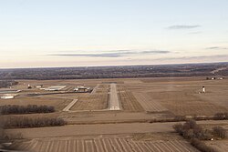
Philip Billard airport - runway 36
  • IATA: TOP
  • ICAO: KTOP
  • FAA LID: TOP
Summary
Airport typePublic
OwnerMetropolitan Topeka Airport Authority
LocationTopeka, Kansas
Elevation AMSL881 ft / 269 m
Coordinates39°04′07″N 095°37′21″W / 39.06861°N 95.62250°W / 39.06861; -95.62250
Websitewww.mtaa-topeka.org/billard-airport
Map
TOP is located in Kansas
TOP
TOP
Location of airport in Kansas
TOP is located in the United States
TOP
TOP
TOP (the United States)
Runways
Direction Length Surface
ft m
13/31 5,099 1,554 Asphalt
18/36 4,331 1,320 Asphalt
Statistics (2019)
Aircraft operations (year ending 7/31/2019)16,447
Based aircraft77
Source: Federal Aviation Administration[1]

Philip Billard Municipal Airport (IATA: TOP, ICAO: KTOP, FAA LID: TOP) is a public airport three miles (4.8 km) northeast of downtown Topeka, the capital city of Kansas and the county seat of Shawnee County. It is owned by the Metropolitan Topeka Airport Authority.[1]

Commercial airline service for Topeka used this airport until 1976. Beginning in the early 1940s TWA, Continental, and Braniff Airways stopped here, and Ozark appeared for a couple years starting around 1951. Braniff left in 1954 and Continental in 1961; Central replaced TWA in 1958 and merged into the original Frontier Airlines in 1967. Frontier continued serving the airport until the move to Forbes Field, now the Topeka Regional Airport, in 1976.[2]

  1. ^ a b FAA Airport Form 5010 for TOP PDF Effective May 16, 2024.
  2. ^ individual airline timetables from timetableimages.com

and 8 Related for: Philip Billard Municipal Airport information

Request time (Page generated in 0.899 seconds.)

Philip Billard Municipal Airport

Last Update:

Philip Billard Municipal Airport (IATA: TOP, ICAO: KTOP, FAA LID: TOP) is a public airport three miles (4.8 km) northeast of downtown Topeka, the capital...

Word Count : 265

Topeka Airport

Last Update:

Topeka Airport can refer to several airports in Topeka, Kansas: Topeka Regional Airport Philip Billard Municipal Airport This disambiguation page lists...

Word Count : 57

Topeka Regional Airport

Last Update:

During this transition, all airline flights moved from the Philip Billard Municipal Airport to the newly-established Forbes Field. On June 1, 1976, the...

Word Count : 2217

List of airports in Kansas

Last Update:

airports assigned an IATA airport code. The largest airport located in the state is Wichita Dwight D. Eisenhower National Airport, a Class C airport....

Word Count : 603

Tornado outbreak sequence of June 1966

Last Update:

Topeka forecast office, located at Philip Billard Municipal Airport, took shelter as the tornado tracked through the airport, flipping over several airplanes...

Word Count : 1560

Geography of Kansas

Last Update:

Weather Bureau Office from June 1887 to July 1946, and at Philip Billard Municipal Airport since August 1946. For more information, see Threadex 1981–2010...

Word Count : 1942

List of Class D airports in the United States

Last Update:

rules and equipment requirements. List of Class B airports in the United States List of Class C airports in the United States FAA Order JO 7400.2L, Procedures...

Word Count : 4793

Effects of Hurricane Andrew in Florida

Last Update:

Archived from the original on 2014-04-17. Retrieved 2017-06-05. Mary Billard (1992-10-04). "The Executive Life; After the Hurricane, Burger King Changes"...

Word Count : 8965

PDF Search Engine © AllGlobal.net