Global Information Lookup Global Information

Peterview information


Peterview, Newfoundland & Labrador
Peters Arm
Town
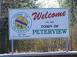
Peterview's welcome sign on the only road into the community.
Official seal of Peterview, Newfoundland & Labrador
Peterview, Newfoundland & Labrador is located in Newfoundland
Peterview, Newfoundland & Labrador
Location of Peterview in Newfoundland
Coordinates: 49°8′55″N 55°21′02″W / 49.14861°N 55.35056°W / 49.14861; -55.35056
CountryPeterview Canada
ProvincePeterview Newfoundland and Labrador
Census division6
Incorporated1962
Government
Area
 • Total6.72 km2 (2.59 sq mi)
Elevation
12 m (39 ft)
Population
 (2021)
 • Total723
 • Density123.2/km2 (319/sq mi)
Time zoneUTC-3:30 (Newfoundland Time)
 • Summer (DST)UTC-2:30 (Newfoundland Daylight)
Postal code span
A0H
Area code709
HighwaysPeterview Route 350
Websitehttp://www.peterview.ca/

Peterview is a town located in the Exploits Valley area of central Newfoundland and Labrador, Canada, where Peters River empties into the Bay of Exploits, just south of Botwood, off Route 350.

Originally named Peters Arm, the community was incorporated as the Town of Peterview in 1962. The mayor is Jim Samson and the deputy mayor is Pleman Brown. According to the 2001 Statistics Canada census, Peterview has a population of 807 with 266[1] private dwellings.

Peterview has connections to Demasduit, also known as Mary March, a figure in Newfoundland history and one of the last Beothuks, as John Peyton, one of her captors, built the first house in the area.[2]

  1. ^ Population and dwelling counts
  2. ^ "Let's cleanse the landscape of the name of a Beothuk killer | CBC News".

and 7 Related for: Peterview information

Request time (Page generated in 0.5541 seconds.)

Peterview

Last Update:

Peterview is a town located in the Exploits Valley area of central Newfoundland and Labrador, Canada, where Peters River empties into the Bay of Exploits...

Word Count : 244

Qalipu First Nation

Last Update:

(Qapskuk) Leading Tickles Millertown Norris Arm (Kepapskek) Northern Arm Peterview Point Leamington St. Alban's (Sipko'p) Councillor: Charlene Combdon Election...

Word Count : 1761

Demographics of Newfoundland and Labrador

Last Update:

Summerford 906 74 Whitbourne 890 75 LaScie 872 76 Cape St. George 853 77 Peterview 828 78 Robert's Arm 805 79 Port aux Choix 789 80 Glenwood 778 81 Milltown-Head...

Word Count : 1574

List of population centres in Newfoundland and Labrador

Last Update:

Arm Old Perlican Pacquet Paradise Parkers Cove Parson's Pond Pasadena Peterview Petty Harbour-Maddox Cove Pilley's Island Pinware Placentia Point au Gaul...

Word Count : 189

List of municipalities in Newfoundland and Labrador

Last Update:

Town 368 345 +6.7% 12.34 29.8 Pasadena Town 3,524 3,620 −2.7% 49.17 71.7 Peterview Town 723 828 −12.7% 6.34 114.0 Petty Harbour-Maddox Cove Town 947 960...

Word Count : 845

Newfoundland and Labrador Route 350

Last Update:

contains several side roads to communities located off the route, such as Peterview, and Route 352 that leads to Point of Bay and the Cottrell's Cove-Fortune...

Word Count : 361

List of Newfoundland and Labrador highways

Last Update:

near Price Farm Route 3-1-20, Old Badger Road in Badger Route 350-13, Peterview Road Route 350-17, Pleasantview Road Route 350-21, Glovers Harbour Road...

Word Count : 2795

PDF Search Engine © AllGlobal.net