 Global Information
Pendoggett information
50°34′54″N 4°47′24″W / 50.58167°N 4.79000°W
Pendoggett
| |
|---|---|
 China Down | |
| Population | 175 |
| OS grid reference | SW997809 |
| Civil parish |
|
| Unitary authority |
|
| Ceremonial county |
|
| Region |
|
| Country | England |
| Sovereign state | United Kingdom |
| Post town | ST KEW |
| Postcode district | PL30 |
| Dialling code | 01208 |
| Police | Devon and Cornwall |
| Fire | Cornwall |
| Ambulance | South Western |
| UK Parliament |
|
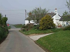
Pendoggett (Cornish: Penndewgos)[1] is a village in the civil parish of St Kew, Cornwall, England, United Kingdom. It is a linear village stradling the B3314 Wadebridge to Delabole road about five miles (8 km) northwest of Wadebridge, four miles (6.5 km) southeast of Delabole, and two miles (3 km) southeast of Port Isaac.[2]
Pendoggett has a population of about 175 people. The name means head of two woods in Cornish; 'Penn' meaning head, 'dew' meaning two and 'goes' being a mutation of 'koes' which means wood. The Cornish Arms is a 16th-century inn.[3]
The boundary of the Cornwall Area of Outstanding Natural Beauty (AONB) follows the B3314 through Pendoggett village, meaning that part of the village is inside the AONB and part is outside.[4]
- ^ Place-names in the Standard Written Form (SWF) Archived 15 May 2013 at the Wayback Machine : List of place-names agreed by the MAGA Signage Panel Archived 15 May 2013 at the Wayback Machine. Cornish Language Partnership.
- ^ Ordnance Survey: Landranger map sheet 200 Newquay & Bodmin ISBN 978-0-319-22938-5
- ^ "The Cornish Arms at Pendoggett". Archived from the original on 21 March 2012. Retrieved 30 October 2011.
- ^ "Geoindex onshore". British Geological Survey. Natural Environment Research Council. 2020. Retrieved 19 June 2021.