Pen y Fan in the Brecon Beacons National Park (green area)
Location
Powys, Wales
Parent range
Brecon Beacons
OS grid
SO012215
Topo map
OS Landranger 160, Explorer OL12
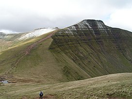
Pen y Fan (Welsh pronunciation:[ˌpɛnəˈvan]) is the highest peak in South Wales, situated in Brecon Beacons National Park (Bannau Brycheiniog). At 886 metres (2,907 ft) above sea-level, it is also the highest British peak south of Cadair Idris in Snowdonia. It is the highest point (county top) of the historic county of Brecknockshire (though in modern administrative terms, it now lies within the unitary council area of Powys). The twin summits of Pen y Fan and Corn Du at 873 metres (2,864 ft) were formerly referred to as Cadair Arthur or 'Arthur's Seat'.[1]
The mountain and surrounding area are owned by the National Trust whose work parties attempt to combat the erosion caused by the popularity of this peak with walkers. The mountain is used by the military as part of the selection process of the UK's Special Forces personnel. Three soldiers who died after collapsing in the field in July 2013 were taking part in a test march called Point-to-Point while undergoing Special Air Service selection.[2][3]
^Nuttall, John & Anne (1999). The Mountains of England & Wales - Volume 1: Wales (2nd edition ed.). Milnthorpe, Cumbria: Cicerone. ISBN 1-85284-304-7.
^"Cpl James Dunsby suffered organ failure after SAS Brecon Beacons training". BBC News. 8 August 2013.
^"Brecon Beacons deaths: relatives attack failure to prosecute senior officers". The Guardian. 18 September 2018. Retrieved 2 July 2022.
PenyFan (Welsh pronunciation: [ˌpɛn ə ˈvan]) is the highest peak in South Wales, situated in Brecon Beacons National Park (Bannau Brycheiniog). At 886...
mountain range in Wales. The range includes South Wales's highest mountain, PenyFan (886 metres (2,907 ft)), its twin summit Corn Du (873 metres (2,864 ft))...
centre. The national park includes the highest mountain in South Wales, PenyFan, which has an elevation of 886 metres (2,907 ft). The national park has...
Corn Du is a summit of the twin topped PenyFan and the second highest peak in South Wales at 871.5 m (2,864 ft), situated in the Brecon Beacons National...
isolation of the range, especially when compared with the more popular PenyFan range to the east. The Beacons Way, a waymarked long distance footpath...
route follows the old Roman road, before going back on itself, ascending PenyFan again for the return leg. Candidates are allowed 4 hours 10 minutes to...
ISBN 1-85284-304-7. "Fany Big mountain in Brecon Beacons downgraded to hill". BBC. Retrieved 16 August 2018. "Brecon Four Peaks (Corn Du, PenyFan, Cribyn, Fany Big)"...
It is the third highest mountain in Britain south of Snowdonia (after PenyFan and its near neighbour Corn Du). It is situated at the head of the Grwyne...
Beacons National Park covers about a third of south Wales, containing PenyFan, the highest British mountain south of Cadair Idris in Snowdonia. A point...
It is of glacial origin, occupying a rock hollow beneath the peaks of PenyFan and Corn Du in the central Brecon Beacons. It is drained by the Nant Cwm...
Y Gyrn is a top of PenyFan in South Wales, situated in the Brecon Beacons National Park. Tommy Jones' Obelisk is found in between the summit and Corn...
Tor y Foel making for the head of Glyn Collwn above Talybont Reservoir. The route then crosses the highest peaks in the central Beacons: PenyFan and...
Bwlch y Ddeufaen separates Tal yFan from the main Carneddau ridge, the closest summit on which is Carnedd y Ddelw. Peny Castell is directly opposite to...
seen on the horizon to the south, across the gently falling dip slope. PenyFan and Corn Du are distinctive landmarks seen directly to the east across...
of the different mountain massifs including South Wales' highest point PenyFan at 886m. Like many other upland national parks in the UK, it is glacial...
calendar year, starting with Cross Fell on 1 January, and ending with PenyFan. Chase was also only the seventh person recorded to have climbed all P600s...
(64 km) with full equipment before climbing up and down the mountain PenyFan (886 m; 2,907 ft) in 20 hours. By the end of this phase, candidates must...
with the exception of the three most recent areas known as Pen-Gurnos, Pen-y-Dre and Pen-y-Fan View. The area built since the 1970s is still often referred...
769 m (2,523 ft) and it tops a large boggy plateau rising to the east of PenyFan. The hill takes the form of a plateau with sharp rims on several sides...
Wales. A triangulation point shows 466 feet (142 m) above sea level at Pen-y-fan. Although Dinas Head is the northernmost part of the promontory where...
Peny Castell is a summit in the Carneddau mountains in north Wales. It tops the east ridge of Drum (Wales). The summit consists of rocky outcrops amid...
The Brecon Beacons (Bannau Brycheiniog) are in the south (highest point PenyFan, at 886 metres (2,907 feet)), and are joined by the Cambrian Mountains...
 Global Information