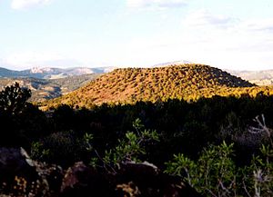
Bald Knoll is the youngest of a group of cinder cones on the SW part of the Paunsaugunt Plateau in southern Utah.
The Paunsaugunt Plateau (pronounced "PAWN-suh-gant") is a dissected plateau, rising to an elevation of 7,000–9,300 feet (2,100–2,800 m), in southwestern Utah in the United States. Located in northern Kane County and southwestern Garfield County, it is approximately 10 miles (16 km) wide, and extends southward from the Sevier Plateau approximately 25 miles (40 km), terminating in the Pink Cliffs at the southern end.
It is drained by the East Fork Sevier River which flows northward on the plateau, to the meet the main branch (Sevier River) which flows in a valley along the western side of the plateau. The plateau is highly dissected along the eastern flank, which is drained by the Paria River in the Colorado River watershed, and is protected as Bryce Canyon National Park. A section of the Great Basin Divide is along the plateau, and much of the plateau is part of Dixie National Forest. The plateau receives approximately 200 inches (5,100 mm) of snow per year and experiences approximately 200 days of freeze-and-thaw cycles. Utah's Highway 12, an All-American Road, crosses the Paunsaugunt Plateau.
Geologically the plateau was created approximately 10-20 million years ago by an uplift on the larger Colorado Plateau. The uplifting caused the formation of joints along the side of the plateau. Subsequent erosive forces, especially along the eastern side in Bryce Canyon National Park, have resulted in the creation of strange rock formations called hoodoos which are the hallmark of the park.
A diagram of the plateau
and 20 Related for: Paunsaugunt Plateau information
The PaunsauguntPlateau (pronounced "PAWN-suh-gant") is a dissected plateau, rising to an elevation of 7,000–9,300 feet (2,100–2,800 m), in southwestern...
collection of giant natural amphitheaters along the eastern side of the PaunsauguntPlateau. Bryce is distinctive due to geological structures called hoodoos...
east–west direction. Two of these faults bound the PaunsauguntPlateau; the Sevier on the west and the Paunsaugunt on the east. Movement along these two faults...
Garfield County, Utah, United States. The hollow is located on the PaunsauguntPlateau, almost entirely in Dixie National Forest, but extends slightly into...
660 Bryce Canyon is a geological amphitheater on southern Utah's PaunsauguntPlateau with hundreds of tall, multicolored sandstone hoodoos formed by erosion...
States. It is the youngest volcano at the southwest portion of the PaunsauguntPlateau and it consists of basaltic lava with a well-preserved volcanic crater...
easternmost part of the cliffs are located on the southeastern edge of the PaunsauguntPlateau in southwestern Garfield County (mostly within Bryce Canyon National...
SR-24, using a different route than the old SR-117 north of Grover. PaunsauguntPlateau SR-12 goes north up the canyon in the upper left of the photo after...
Distant views to the Escalante Mountains, Sevier Plateau, and the Pink Cliffs of PaunsauguntPlateau are visible to the south and east. On this leg of...
Garfield County from several creeks that descend from the edge of the PaunsauguntPlateau, meeting just north of Tropic. It flows SSE across Kane County and...
characterize the Markagunt, Paunsaugunt, and Aquarius Plateaus. Boulder Mountain, one of the largest high-elevation plateaus in the United States, is dotted...
elevation of 7,310 ft (2,230 m) between the Markagunt Plateau (on the west) and the PaunsauguntPlateau.: 82 The river flows north through a wide valley...
436 m) 21 Bryce Canyon UT0621 Rainbow Point [1][permanent dead link] PaunsauguntPlateau 9,115 feet (2,778 m) Yellow Creek 6,565 feet (2,001 m) 2,550 feet...
hoodoos from the developed portion of the park on the rim of the PaunsauguntPlateau. Five trails are included in the NRHP district: the Navajo Loop Trail...
Formation in Utah. It can be found on the Markagunt, Aquarius, and PaunsauguntPlateaus. It occurs within the bounds of the Dixie National Forest and Cedar...
Cretaceous Mammals from Bryce Canyon National Park and Vicinity, PaunsauguntPlateau, Southwestern Utah". In Alan L. Titus; Mark A. Loewen (eds.). At...
services area in the 1930s. The complex is located near the edge of the PaunsauguntPlateau in the northern end of the park, centered on the Bryce Canyon Lodge...
Cretaceous stratigraphy and vertebrate faunas of the Markagunt, Paunsaugunt, and Kaiparowits plateaus, southern Utah". Geology of the Intermountain West. 3: 229–291...
Cretaceous stratigraphy and vertebrate faunas of the Markagunt, Paunsaugunt, and Kaiparowits plateaus, southern Utah". Geology of the Intermountain West. 3: 229–291...
 Global Information