White light every 6 s; two red sectors marking dangerous shoals
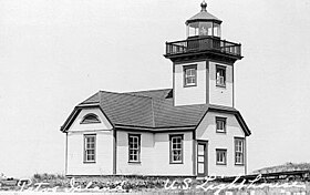
Patos Island Light Station
U.S. National Register of Historic Places
Nearest city
Eastsound, Washington
Area
1 acre
Built
1893 (1893)
Architectural style
Greek Revival-Victorian
NRHP reference No.
77001355[2]
Added to NRHP
October 21, 1977
Patos Island Lighthouse is an active aid to navigation overlooking the Strait of Georgia at Alden Point on the western tip of Patos Island in the San Juan Islands, San Juan County, Washington, in the United States.[3] The station is the northernmost in the San Juan Islands and marks the
division point between the eastern and western passages into the Strait of Juan de Fuca.[4]
In 2013, Patos Island and its lighthouse were included in the US Presidential Proclamation[5] by Barack Obama creating San Juan Islands National Monument,[6] managed by the Bureau of Land Management, part of the US Department of Interior. Limited developments on the island are managed in partnership with Washington State Parks and volunteers with the nonprofit friends group Keeper of the Patos Light.[7] On some maps it is also referred to as Patos Island State Park.[8]
Access to Patos Island is challenging; no public ferry system serves the 200 acre island. Two offshore mooring buoys are available for private boats as permitted through the Washington State Parks.[9] Volunteer opportunities, however, offer regular summer access through the Keepers of the Patos Light.[7]
Through a Washington State Lighthouse Environmental Program (LEP) grant, the Keeper of the Patos Light are developing exhibits for the lighthouse.
^"Patos Light". Geographic Names Information System. United States Geological Survey, United States Department of the Interior.
^"National Register Information System". National Register of Historic Places. National Park Service. July 9, 2010.
^Cite error: The named reference inventory was invoked but never defined (see the help page).
^Cite error: The named reference nomination was invoked but never defined (see the help page).
^"Presidential Proclamation -- San Juan Islands National Monument". whitehouse.gov. 2013-03-25. Retrieved 2017-03-07.
^"San Juan Islands National Monument Oregon/Washington BLM". www.blm.gov. Archived from the original on 2017-03-08. Retrieved 2017-03-07.
^ ab"Keepers of the Patos Light - Keepers of the Patos Light". Keepers of the Patos Light. Retrieved 2017-03-07.
^Cite error: The named reference wasp was invoked but never defined (see the help page).
^"Patos Island Marine State Park | Washington State Parks and Recreation Commission". parks.state.wa.us. Retrieved 2017-03-07.
and 27 Related for: Patos Island Light information
PatosIsland Lighthouse. Keepers of the PatosLightPatosIslands Archived 2013-04-03 at the Wayback Machine Bureau of Land Management PatosIsland State...
PatosIsland is a small island in the San Juan Islands of the U.S. state of Washington. Since 1893, it has been home to the PatosIsland Lighthouse, guiding...
the northern end of Boundary Pass, between PatosIslandLight on PatosIsland and East Point on Saturna Island. Rosario Strait is also a major shipping...
The Cape Disappointment Light is a lighthouse on Cape Disappointment near the mouth of the Columbia River in the U.S. state of Washington. In 1848, it...
WA". LighthouseFriends. Archived from the original on 2010-03-23. "PatosIsland, WA". LighthouseFriends. "Point Robinson, WA". LighthouseFriends. Archived...
1968. p. F2. Retrieved April 28, 2015. "Destruction IslandLight". Inventory of Historic Light Stations: Washington Lighthouses. National Park Service...
The Clover IslandLight is a 62 feet (19 m) tall lighthouse along the Columbia River on Clover Island in Kennewick, Washington. Completed in 2010, it is...
The Light on the Island, by Helene Glidden, recounts her early years in the lighthouse on PatosIsland in Washington State's San Juan Islands. Set during...
Washington. It is part of Cape Disappointment State Park. The North Head Light was constructed in 1897 after mariners complained that the Cape Disappointment...
Clover Island Yacht Club is located on the island, as well as a two lane boat launch and a 62 feet (19 m) tall lighthouse. The Clover IslandLight is the...
the tower's light stands 165 feet (50 m) above water. A fog signal building with a 12-inch (300 mm) steam whistle was built on the island in 1872. The...
The Burrows IslandLight is a lighthouse on the western tip of Burrows Island, facing Rosario Strait, near Anacortes, in Skagit County, Washington. After...
The Admiralty Head Light is a deactivated aid to navigation located on Whidbey Island near Coupeville, Island County, Washington, on the grounds of Fort...
The Grays Harbor Lighthouse (Westport Light) is a lighthouse located on Point Chehalis on the southern side of the entrance to Grays Harbor, Westport...
Pierce County, Washington. Cupy the first light station on Browns Point, erected in 1887, consisted of a white light lens lantern on a white post that stood...
related to Smith Island Lighthouse. The Smith IslandLight was a lighthouse on Smith Island, Island County, Washington. The Smith IslandLight was constructed...
2009. Light List, Volume VI, Pacific Coast and Pacific Islands (PDF). Light List. United States Coast Guard. 2009. p. 136. "West Point Light". Inventory...
The Mukilteo Light is an operational navigation aid located on the east side of Possession Sound at Mukilteo, Snohomish County, Washington, in the United...
Anacapa IslandLight, California 273 feet (83 m) - Point Sur Light, California 258 feet (79 m) - Block Island Southeast Light, Rhode Island (since its...
Lime Kiln Light is a functioning navigational aid located on Lime Kiln Point overlooking Dead Man's Bay on the western side of San Juan Island, San Juan...
The Point Wilson Light is an active aid to navigation located in Fort Worden State Park near Port Townsend, Jefferson County, Washington. It is one of...
the northern end of Boundary Pass, between PatosIslandLight on PatosIsland and East Point on Saturna Island. Much shorter than the Rosario Strait, though...
northeastern entrance to Budd Inlet north of Olympia. It is the southernmost light in Puget Sound and is listed on the National Register of Historic Places...
Washington. It is listed as Alki Point Light number 16915 in the USCG light lists. The first, unofficial, light established at Alki Point was a kerosene...
The Point Roberts Light is an aid to navigation located in Point Roberts, Whatcom County, Washington State, United States. The skeletal structure overlooks...
The Marrowstone Point Light is an active navigational aid overlooking Admiralty Inlet at the northern tip of Marrowstone Island, Jefferson County, Washington...
original light was replaced by a freestanding tower in 1951, which was discontinued around 2000 and replaced with a buoy light. The Slip Point Light was constructed...
 Global Information