This article needs additional citations for verification. Please help improve this article by adding citations to reliable sources. Unsourced material may be challenged and removed. Find sources: "Pathum Thani province" – news · newspapers · books · scholar · JSTOR(August 2019) (Learn how and when to remove this message)
Province of Thailand
Province in Thailand
Pathum Thani
ปทุมธานี
Province
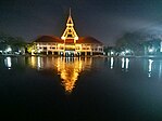
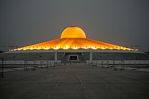
Clockwise from top left: Thailand National Memorial, A Royal Ploughing Ceremony exhibition in Golden Jubilee Museum of Agriculture, Tornado ride in the Dream World, Wat Phra Dhammakaya, National Science Museum, Thammasat University's pond.
Flag
Seal
Motto(s):
ถิ่นบัวหลวง เมืองรวงข้าว เชื้อชาวมอญ นครธรรมะ พระตำหนักรวมใจ สดใสเจ้าพระยา ก้าวหน้าอุตสาหกรรม ("Home of the royal lotus. Town of rice ears. Mon people. City of Dharma. Palace of unity. Bright Chao Phraya (River). Progressive industry.")
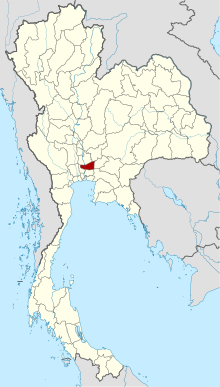
Map of Thailand highlighting Pathum Thani province
Country
Thailand
Region
Central Thailand
Capital
Pathum Thani
Largest City
Rangsit
Government
• Governor
Vacant
Area
[1]
• Total
1,526 km2 (589 sq mi)
• Rank
Ranked 70th
Population
(2019)[2]
• Total
1,163,604
• Rank
Ranked 18th
• Density
763/km2 (1,980/sq mi)
• Rank
Ranked 5th
Human Achievement Index
[3]
• HAI (2022)
0.6589 "somewhat high" Ranked 15th
GDP
[4]
• Total
baht 381 billion (US$13 billion) (2019)
Time zone
UTC+7 (ICT)
Postal code
10xxx
Calling code
02
ISO 3166 code
TH-13
Website
pathumthani.go.th
Pathum Thani (Thai: ปทุมธานี, pronounced[pā.tʰūmtʰāːnīː]) is one of the central provinces (changwat) of Thailand. Neighboring provinces are (from north clockwise): Phra Nakhon Si Ayutthaya, Saraburi, Nakhon Nayok, Chachoengsao, Bangkok, and Nonthaburi.
The province is north of Bangkok and is part of the Bangkok metropolitan area. In many places, the boundary between the two provinces is not noticeable as both sides of the boundary are equally urbanized. Pathum Thani town is the administrative seat, but Ban Rangsit, seat of Thanyaburi district, is the largest populated place in the province.[5]
Pathum Thani is an old province, heavily populated by the Mon people, dotted with 186 temples and parks. The Dream World amusement park is here.[citation needed]
^Advancing Human Development through the ASEAN Community, Thailand Human Development Report 2014, table 0:Basic Data (PDF) (Report). United Nations Development Programme (UNDP) Thailand. pp. 134–135. ISBN 978-974-680-368-7. Retrieved 17 January 2016, Data has been supplied by Land Development Department, Ministry of Agriculture and Cooperatives, at Wayback Machine.{{cite report}}: CS1 maint: postscript (link)[dead link]
^"สถิติทางการทะเบียน" [Registration statistics]. bora.dopa.go.th. Department of Provincial Administration (DOPA). December 2019. Retrieved 22 September 2020. Download จำนวนประชากร ปี พ.ศ.2562 - Download population year 2019
^"ข้อมูลสถิติดัชนีความก้าวหน้าของคน ปี 2565 (PDF)" [Human Achievement Index Databook year 2022 (PDF)]. Office of the National Economic and Social Development Council (NESDC) (in Thai). Retrieved 12 March 2024, page 42{{cite web}}: CS1 maint: postscript (link)
^"Gross Regional and Provincial Product, 2019 Edition". <>. Office of the National Economic and Social Development Council (NESDC). July 2019. ISSN 1686-0799. Retrieved 22 January 2020.
^"Population Statistics 2008". Department of Provincial Administration. Archived from the original on 2010-03-25. Retrieved 2010-06-28. Pathum Thani town population 18,843; Rangsit town population 76,843
and 24 Related for: Pathum Thani province information
PathumThani (Thai: ปทุมธานี, pronounced [pā.tʰūm tʰāːnīː]) is one of the central provinces (changwat) of Thailand. Neighboring provinces are (from north...
north of Bangkok. It is the capital of the PathumThaniprovince, Thailand as well as the Mueang PathumThani district. As of 2005, it has a population...
Mueang PathumThani (Thai: เมืองปทุมธานี, pronounced [mɯ̄a̯ŋ pā.tʰūm tʰāː.nīː]) is the capital district (amphoe mueang) of PathumThaniprovince, central...
คลองหลวง, pronounced [kʰlɔ̄ːŋ lǔa̯ŋ]) is a district (amphoe) in PathumThaniprovince, central Thailand. Originally, the area was part of the Bang Wai...
(Thai: ลำลูกกา, pronounced [lām lûːk kāː]) is a district (amphoe) of PathumThaniprovince, part of Bangkok Metropolitan Region. Originally, Lam Luk Ka was...
University (Thai: มหาวิทยาลัยรังสิต) (RSU) is a private university in PathumThani, Thailand, focusing mainly on music, design, Information technology,...
(Thai: รังสิต, pronounced [rāŋ.sìt]) is a city and neighbourhood in PathumThaniProvince, Thailand. Rangsit is a metropolitan city that supports the expansion...
Thai: มหาวิทยาลัยเทคโนโลยีราชมงคลธัญบุรี) is a public university in PathumThaniProvince, Thailand. It was established on January 18, 2005, and is a member...
ธัญบุรี, pronounced [tʰān.já(ʔ).bū.rīː]) is a district (amphoe) in PathumThaniprovince. Mueang Thanyaburi was built by order of King Rama V in 1901. The...
the east, Mueang Nonthaburi district of Nonthaburi province to the south, and PathumThaniprovince to the north. It is part of the Bangkok Metropolitan...
clockwise): Mueang PathumThani and Lam Luk Ka of PathumThaniprovince; Sai Mai, Bang Khen and Lak Si of Bangkok; and Pak Kret of Nonthaburi province. Don Mueang...
of Mueang PathumThani of PathumThaniProvince, Don Mueang and Lak Si of Bangkok, Mueang Nonthaburi and Bang Bua Thong of Nonthaburi Province, it attracts...
[bāːŋ kʰūː wát]) is a tambon (subdistrict) of Mueang PathumThani district, PathumThaniprovince, central Thailand. In the past, Bang Khu Wat was an area...
called Thai Beer. Other Thai beers are Phuket Beer and Siam, both in PathumThaniProvince. Siam Beer exports Bangkok Beer abroad, but does not sell it in...
Chatuchak - now defunct Happy Land, Bangkapi - now defunct KidZania Bangkok, Pathum Wan Safari World, Ramindra Km.9 Siam Park City, Seri Thai Chiang Mai Night...
construction in the U Place Condotel condominium project, collapsed in PathumThaniprovince, Thailand. The collapse resulted in 14 deaths and 25 injuries to...
It is bounded by (from north clockwise): Lam Luk Ka district of PathumThaniprovince; Khlong Sam Wa, Bang Khen and Don Mueang of Bangkok. Sai Mai was...
clockwise): Amphoe Lam Luk Ka of PathumThaniprovince, Amphoe Bang Nam Priao and Amphoe Mueang Chachoengsao of Chachoengsao province, Lat Krabang, Min Buri and...
[kʰūː kʰót]) is a tambon (sub-district) in Lam Luk Ka district of PathumThaniprovince, Greater Bangkok. Originally, Sai Mai used to be a muban (village)...
the Irrawaddy Delta, and several areas in Thailand (mostly in PathumThaniprovince, Phra Pradaeng and Nong Ya Plong). The native language is Mon, which...
Thanyaburi is a municipality in central Thailand, in PathumThaniProvince, about 40 km north of Bangkok. Recent population estimates cited on the Internet...
Education, Science, Research and Innovation. Its headquarters is in PathumThaniProvince, Thailand. Thailand Institute of Scientific and Technological Research...
other districts (from north clockwise): Lam Luk Ka district of PathumThaniprovince, Nong Chok, Min Buri, Khan Na Yao, Bang Khen, and Sai Mai of Bangkok...
ลาดหลุมแก้ว, pronounced [lâːt lǔm kɛ̂ːw]) is the westernmost district of PathumThaniprovince, central Thailand. The district was established on 28 March 1916...
 Global Information