Paraparaumu (Māori:[ˈpaɾapaˈɾaʉmʉ])[3] is a town in the south-western North Island of New Zealand. It lies on the Kāpiti Coast, 55 kilometres (34 mi) north of the nation's capital city, Wellington. It is also known to residents as Pram or Paraparam.
Like other towns in the area, it has a partner settlement at the coast called Paraparaumu Beach, which is directly opposite Kapiti Island. The two towns form part of the Kāpiti Coast District. Together with the nearby Raumati Beach and Raumati South they are among the fastest-growing urban areas in New Zealand, and are major dormitory towns with workers commuting to the cities that make up the Wellington urban area. The four towns between them have a 2012 population of over 49,000 people.[4] Inland behind Paraparaumu is the Maungakotukutuku area.
Paraparaumu is a Māori-language name meaning "scraps from an earth oven"; parapara means "dirt" or "scraps", and umu means "oven".[5]
The village of Lindale is just north of the Paraparaumu town centre. It began as a Tourist and Agricultural Centre, but later gained a reputation for cheese and the Lindale Barnyard petting farm.[6][7][8]
The old State Highway 1 and the Kapiti Line section of the North Island Main Trunk railway both pass through Lindale. The railway line was formerly owned by the Wellington and Manawatu Railway Company, and construction of the line was completed when the ends from Wellington and Longburn (Palmerston North) met near Lindale in Otaihanga in 1886. There were proposals to extend the commuter train service operated by Transdev Wellington to a new station at Lindale, subject to Wellington Regional Council funding, but these were dropped when electrification for the commuter service was extended from Paraparaumu to Waikanae.[9]
The majority of shops are located close to the town centre in the Coastlands Mall, close to the train station.
^Cite error: The named reference Area was invoked but never defined (see the help page).
^"Subnational population estimates (RC, SA2), by age and sex, at 30 June 1996-2023 (2023 boundaries)". Statistics New Zealand. Retrieved 25 October 2023. (regional councils); "Subnational population estimates (TA, SA2), by age and sex, at 30 June 1996-2023 (2023 boundaries)". Statistics New Zealand. Retrieved 25 October 2023. (territorial authorities); "Subnational population estimates (urban rural), by age and sex, at 30 June 1996-2023 (2023 boundaries)". Statistics New Zealand. Retrieved 25 October 2023. (urban areas)
^/ˌpærəpəˈraʊmuː/, thouɡh typically pronounced /ˌpærəˌpærəˈuːmuː/. In Māori vowels are run together, even when they are brought together by the creation of compound words. See for example [1] Archived 21 July 2011 at the Wayback Machine
^Kapiti Coast Distinct Council, Community Profile Archived 2008-10-14 at the Wayback Machine
^"Chris Maclean, "Wellington Places – Kapiti Coast", Te Ara". Archived from the original on 27 April 2008. Retrieved 20 June 2008.
^"Weblog NZ feature, April 2003". Archived from the original on 20 December 2016. Retrieved 23 November 2018.
^OSNZ – Breeding biology of little shags (Phalacrocorax melanoleucos) at Lindale
^"Lindale Village". Archived from the original on 23 November 2018. Retrieved 23 November 2018.
^"Scoop – Lindale Bridge nearly finished, October 2004". Archived from the original on 29 October 2004. Retrieved 23 November 2018.
Paraparaumu (Māori: [ˈpaɾapaˈɾaʉmʉ]) is a town in the south-western North Island of New Zealand. It lies on the Kāpiti Coast, 55 kilometres (34 mi) north...
Paraparaumu College is a Year 9 to 13 co-educational state school on the Kāpiti Coast of New Zealand, approximately 45 minutes drive north of Wellington...
Paraparaumu Beach is a coastal settlement on the Kāpiti Coast of New Zealand's North Island. It is located west of the main Paraparaumu township, 50 km...
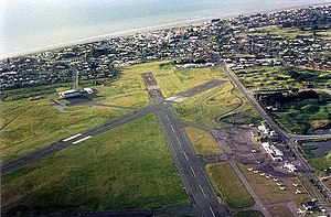
previously called Paraparaumu Airport, is on the Kāpiti Coast of New Zealand's North Island, between the Wellington dormitory suburbs of Paraparaumu Beach (to...
Paraparaumu railway station in Paraparaumu on the Kāpiti Coast, New Zealand is an intermediate station on the Kapiti Line section of the North Island Main...
with stops at 16 stations. Until 20 February 2011 it was known as the Paraparaumu Line. The Kapiti Line was constructed by the Wellington and Manawatu...
Hearts in 2000 then formed as Kapiti Coast United when they merged with Paraparaumu United in 2003. Their highest honour is winning Capital One three times...
album called Keep an Open Heart. Hona died from pancreatic cancer in Paraparaumu, on 5 May 2024, at the age of 70. The Aotearoa Music Awards are an annual...
The 1936 Paraparaumu train wreck occurred on Sunday, 30 August 1936 near Paraparaumu, New Zealand. A train was travelling from Auckland to Wellington...
0 MHz in the CBD, 87.6 MHz in Porirua/Mana, and 87.9 MHz in Waikanae/Paraparaumu. AREC FM is a non-profit donation funded LPFM broadcaster and a subscriber...
Raumati South. It is immediately to the south-west of the larger town of Paraparaumu. The Maungakotukutuku area is located immediately behind Raumati. "Raumati"...
Line along the NIMT to Waikanae on the Kāpiti Coast via Porirua and Paraparaumu; the Melling Line to Lower Hutt via Petone; and the Hutt Valley Line...
headwaters are in the Maungakotukutuku valley, and it flows through Paraparaumu and Raumati Beach before reaching the Tasman Sea on the northern side...
available between Blenheim and Christchurch,Wanaka and Paraparaumu. Nelson also has flights to Paraparaumu. Sounds Air formerly served Kaikoura, Napier and...
the "medium urban area" category to the "large urban area" category is Paraparaumu (30,800). Functional urban areas (FUAs) are geographic areas which represent...
Rugby Player of the Year in 2016. Coles attended Paraparaumu Beach School. He later attended Paraparaumu College and Wellington College. In 2012, Coles...
services are separated from the other urban areas. Paraparaumu services usually terminate at Paraparaumu station, connecting with Kapiti Line trains, and...
co.nz. 30 May 2016. Retrieved 30 May 2016. "Air Chathams will pick up Paraparaumu to Auckland flight route". The New Zealand Herald. Retrieved 2 July 2018...
surface often became unusable during winter months). During the closure, Paraparaumu Airport, 35 miles (56 km) north of Wellington, was Wellington's airport...
includes much of the Kapiti Coast Kapiti Coast Airport, an airport in Paraparaumu Kāpiti College, a high school on the Kapiti Coast Kāpiti Expressway,...
 Global Information