Wooded wetlands along the coast of Tabasco, Mexico
Pantanos de Centla
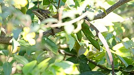
Brown basilisk (toloque rayado) in the Pantanos de Centla
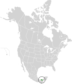
Location map of the Pantanos de Centla
Ecology
Realm
Neotropical
Biome
tropical and subtropical moist broadleaf forests
Borders
Petén–Veracruz moist forests
Usumacinta mangroves,
Yucatan moist forests
Geography
Area
17,028 km2 (6,575 sq mi)
Country
Mexico
States
Campeche
Chiapas
Tabasco
Conservation
Conservation status
Critical/endangered
Protected
5,644 km2 (33%)[1]
Designations
Ramsar Wetland
Official name
Reserva de la Biosfera Pantanos de Centla
Designated
22 June 1995
Reference no.
733[2]
View of the Centla, Tabasco.In "Tres Brazos" the Usumacinta River joins the San Pedrito and Grijalva rivers in the Pantanos de Centla Biosphere Reserve.
The Pantanos de Centla (Centla swamps) are wooded wetlands along the coast in state of Tabasco in Mexico. They have been protected since 2006 with the establishment of the Pantanos de Centla Biosphere Reserve. It is also a World Wildlife Fund ecoregion.
^Eric Dinerstein, David Olson, et al. (2017). An Ecoregion-Based Approach to Protecting Half the Terrestrial Realm, BioScience, Volume 67, Issue 6, June 2017, Pages 534–545; Supplemental material 2 table S1b. [1]
^"Reserva de la Biosfera Pantanos de Centla". Ramsar Sites Information Service. Retrieved 25 April 2018.
and 20 Related for: Pantanos de Centla information
protected area is PantanosdeCentla Biosphere Reserve. In the PantanosdeCentla Biosphere Reserve (Reserva de la Biosfera PantanosdeCentla) was established...
and the two rivers form a large wetland region known as the PantanosdeCentla. The pantanos (wetlands) are designated a biosphere reserve; it contains...
Missouri, United States Okefenokee Swamp, Georgia/Florida, United States PantanosdeCentla, Tabasco/Campeche, Mexico Reelfoot Lake, Tennessee/Kentucky, United...
international importance. The surrounding inland ecoregion is the PantanosdeCentla ecoregion. The climate of the ecoregion is Tropical savanna climate...
the northern lowlands it flows through the eastern extension of the PantanosdeCentla, an expanse of seasonally- to permanently-flooded freshwater swamp...
Azules Biosphere Reserve, Chiapas Ojo de Liebre Lagoon Biosphere Reserve, Baja California Sur PantanosdeCentla Biosphere Reserve, Campeche and Tabasco...
pimento de Tabasco. These areas have suffered the most from slash and burn agriculture. Most of the wetlands of the state belong to the PantanosdeCentla Biosphere...
Palizada flows through the PantanosdeCentla, a large permanently-flooded freshwater swamp forest. As it nears the Laguna de Términos, fresh and salt waters...
hábitat y presencia de Dermatemys mawii (Gray, 1847) en la Reserva de la Biosfera PantanosdeCentla (Doctorate). El Colegio de la Frontera Sur, Villahermosa...
montane forests (Mexico) PantanosdeCentla (Mexico) Petén–Veracruz moist forests (Mexico) Sierra de los Tuxtlas (Mexico) Sierra Madre de Chiapas moist forests...
north of Villahermosa through the wildlife-rich wetlands known as the PantanosdeCentla. These rivers are considered mature, since they are in the lowest...
the existence of a few well-performing utilities such as Aguas y Drenaje de Monterrey. The challenges include water scarcity in the northern and central...
montane forests (Mexico) PantanosdeCentla (Mexico) Petén–Veracruz moist forests (Mexico) Sierra de los Tuxtlas (Mexico) Sierra Madre de Chiapas moist forests...
Reserva de la Biosfera La Encrucijada 144,868 357,980 Reserva de la Biosfera Los Petenes 282,857 698,950 Reserva de la Biosfera PantanosdeCentla 302,706...
/ 20.183; -90.533 (Reserva de la Biosfera Los Petenes) 2,828.57 2 February 2004 Reserva de la Biosfera PantanosdeCentla Tabasco 18°18′N 92°27′W / 18...
 Global Information