Island in the province of Bohol in the Philippines
Panglao Island
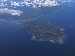
Aerial view of Panglao Island in August 2023
Panglao Island
Location within the Philippines
Show map of Visayas
Panglao Island
Panglao Island (Philippines)
Show map of Philippines
Geography
Location
Bohol Sea
Coordinates
9°36′N123°49′E / 9.6°N 123.82°E / 9.6; 123.82
Area
91.12 km2 (35.18 sq mi)[1]
Length
16 km (9.9 mi)
Width
7.5 km (4.66 mi)
Administration
Philippines
Region
Central Visayas
Province
Bohol
Municipalities
Dauis
Panglao
Largest settlement
Dauis (pop. 52,492)
Demographics
Population
92,331 (2015)[2]
Pop. density
870/km2 (2250/sq mi)
Additional information
Panglao is an island in the north Bohol Sea, located in the Central Visayas region of the Visayas island group, in the south-central Philippines.
^"Philippine Standard Geographic Code (PSGC) - Province: BOHOL". nap.psa.gov.ph. Philippine Statistics Authority. Archived from the original on April 18, 2018. Retrieved April 17, 2018.
^Census of Population (2020). "Region VII (Central Visayas)". Total Population by Province, City, Municipality and Barangay. Philippine Statistics Authority. Retrieved July 8, 2021.
Panglao is an island in the north Bohol Sea, located in the Central Visayas region of the Visayas island group, in the south-central Philippines. The island...
land (climbing the highest point) or by air via ultralight air tours. PanglaoIsland, located just southwest of Tagbilaran, is famous for its diving locations...
the south-west tip of PanglaoIsland, Bohol in the Philippines. The beach is situated less than two miles from the Bohol-Panglao International Airport...
Panglao may refer to either: Panglao, Bohol PanglaoIsland, on which the above municipality is located. This disambiguation page lists articles about distinct...
Machine www.tambuli.com. Retrieved November 15, 2006. "Move over Boracay: PanglaoIsland beckons". inq7.net. Archived from the original on December 17, 2004...
Pangapasan IslandPanglaoIsland Puntod Island Puntod Guindacpan Island Saae Island Sag Island Sagasa Island Sandingan Island Sib Island Silo Island Tabangdio...
Bantayan Island is an island located in the Visayan Sea, Philippines. It is situated to the west of the northern end of Cebu island, across the Tañon Strait...
major port towards the end of the Spanish era when the causeway to PanglaoIsland was constructed. Since then, the area lost its former glory and its...
Hinagdanan Cave is a cave in the municipality of Dauis on PanglaoIsland, in Bohol Province, in the Philippines. It is a naturally lighted cavern with...
The Olango Island Group is a group of islands found in the Central Visayas region of the Philippines. It comprises Olango island and 6 satellite islets...
in Clark International Airport to Busuanga, Puerto Princesa, Caticlan, Panglao, Siargao, and Cebu using its fleet of three ATR 72-500s. Sunlight Air was...
intercontinental destinations. There are two other airports in the region. Bohol–Panglao International Airport serves Bohol and is the region's newest airport....
Apo Island /ˈæpoʊ/ is a volcanic island covering 74 hectares in land area, 7 kilometers off the southeastern tip of Negros Island and 30 kilometers south...
Alburquerque-Loay-Loboc Apo Island Talibon Islands Protected seascapes PanglaoIsland Tañon Strait Game refuge and bird sanctuaries Olango Island Watershed forest...
airport was not capable of operating during nighttime. A new airport in PanglaoIsland was planned to replace Tagbilaran Airport. The feasibility study for...
International Airport LAO Manila Ninoy Aquino International Airport MNL PanglaoIsland Bohol–Panglao International Airport TAG Puerto Princesa Puerto Princesa International...
which contains limestone rock. Dauis is located in the northern part of PanglaoIsland. It is 3 kilometres (1.9 mi) from Tagbilaran. Dauis is politically subdivided...
Strait, southeast of Negros, southwest of Bohol, and north of Mindanao. PanglaoIsland, which is part of Bohol, has a similar soil composition found throughout...
views of the park and surrounding countryside, including the nearby island of Panglao and even Cebu. Near the park's entrance is a tunnel that leads to...
Dauis–Mansasa polity in the modern city of Tagbilaran and the adjecent island of Panglao. The volume of artifacts unearthed in the sites of Dauis and Mansasa...
were subdued by the Visayan migrants from the island-nation called the Kedatuan of Dapitan, on Panglaoisland. In the accounts of Jesuit historian Francisco...
(November 17, 2019). "Management plan, land use plan sought for Bantayan Island". SunStar Publishing Inc. Retrieved January 27, 2024. Media related to National...
Bulkang Kanlaon), is an active stratovolcano and the highest mountain on the island of Negros in the Philippines, as well as the highest peak in the Visayas...
richness and shape complexity in Central Cebu Protected Landscape, Cebu Island, Philippines: Implications in Environmental Management". Asia Life Sciences...
world's best island". ABS-CBN News and Current Affairs. "BORACAY named 2012 No.1 World's Best Island". Boracay Live. July 16, 2012. "Coron Island Natural Biotic...
 Global Information