 Global Information
Pangasinan information
This article needs additional citations for verification. (July 2022) |
Pangasinan | |
|---|---|
Province | |
| Province of Pangasinan | |
        Clockwise from the top: Pangasinan Provincial Capitol, Minor Basilica of Our Lady of Manaoag, St. Vincent Ferrer Statue in Bayambang, Daang Kalikasan Highway in Mangatarem, Tambobong Beach in Dasol, Central Business Area of Urdaneta, Cape Bolinao Lighthouse, and the Hundred Islands National Park in Alaminos. | |
 Flag  Seal | |
| Etymology: Pang-asin-an, lit. "Place where salt is made" | |
| Nickname(s): Land of Miracles and Romance
Salt Capital of the Philippines | |
| Anthem: Luyag Ko Tan Yaman | |
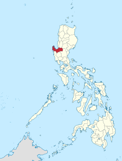 Location in the Philippines | |
OpenStreetMap  | |
| Coordinates: 15°55′N 120°20′E / 15.92°N 120.33°E | |
| Country | Philippines |
| Region | Ilocos Region |
| Founded | April 5, 1580 |
| Capital | Lingayen |
| Largest city | San Carlos |
| Government | |
| • Type | Sangguniang Panlalawigan |
| • Governor | Ramon V. Guico III (NP) |
| • Vice Governor | Mark Ronald D. Lambino (Lakas–CMD) |
| • Legislature | Pangasinan Provincial Board |
| Area [1] | |
| • Total | 5,451.01 km2 (2,104.65 sq mi) |
| • Rank | 15th out of 81 |
| Highest elevation (Mount San Isidro) | 737 m (2,418 ft) |
| Population (2020 census)[2] | |
| • Total | 3,163,190 |
| • Rank | 6th out of 81 |
| • Rank | 11th out of 81 |
| including independent cities | |
| Demonym | Pangasinense |
| Divisions | |
| • Independent cities | 1
|
| • Component cities | 3
|
| • Municipalities | 44
|
| • Barangays |
|
| • Districts | Legislative districts of Pangasinan (shared with Dagupan) |
| Time zone | UTC+8 (PST) |
| ZIP code | 2400–2447 |
| IDD : area code | +63 (0)75 |
| ISO 3166 code | PH-PAN |
| Ethnic groups |
|
| Languages |
|
| Website | www |
Pangasinan, officially the Province of Pangasinan (Pangasinan: Luyag/Probinsia na Pangasinan, [paŋɡasiˈnan];[3] Ilocano: Probinsia ti Pangasinan; Tagalog: Lalawigan ng Pangasinan), is a coastal province in the Philippines located in the Ilocos Region of Luzon. Its capital is Lingayen. Pangasinan is in the western area of Luzon along Lingayen Gulf and the South China Sea. It has a total land area of 5,451.01 square kilometres (2,104.65 sq mi).[1] According to the 2020 census, it has a population of 3,163,190.[2] The official number of registered voters in Pangasinan is 1,651,814.[4] The western portion of the province is part of the homeland of the Sambal people, while the central and eastern portions are the homeland of the Pangasinan people. Due to ethnic migration, the Ilocano people settled in the province.
Pangasinan is the name of the province, the people and the spoken language. Indigenous Pangasinan speakers are estimated to number at least 2 million. The Pangasinan language, which is official in the province, is one of the officially recognized regional languages in the Philippines. Several ethnic groups enrich the cultural fabric of the province. Almost all of the people are Pangasinans and the rest are descendants of the Bolinao and Ilocano who settled the eastern and western parts of the province.[5] Pangasinan is spoken as a second language by many ethnic minorities in Pangasinan. The minority ethnic groups are the Bolinao-speaking Zambals, and Ilocanos.
Popular tourist attractions in Pangasinan include the Hundred Islands National Park in Alaminos the white-sand beaches of Bolinao and Dasol. Dagupan is known for its Bangus Festival ("Milkfish Festival"). Pangasinan is also known for its mangoes and ceramic oven-baked Calasiao puto ("native rice cake"). Pangasinan occupies a strategic geo-political position in the central plain of Luzon. Pangasinan has been described as the gateway to northern Luzon.
- ^ a b "List of Provinces". PSGC Interactive. Makati City, Philippines: National Statistical Coordination Board. Archived from the original on September 12, 2016. Retrieved February 11, 2013.
- ^ a b Census of Population (2020). "Region I (Ilocos Region)". Total Population by Province, City, Municipality and Barangay. Philippine Statistics Authority. Retrieved July 8, 2021.
- ^ Benton, Richard A. (1971). Pangasinan Reference Grammar. Honolulu: University of Hawaii Press. p. 36. ISBN 978-0-8248-7910-5.
- ^ ""Pangasinan voters already 1,651,814," Sunday Punch. December 10, 2012". Archived from the original on May 17, 2013. Retrieved December 26, 2012.
- ^ "Pangasinan: The Most Populated Province in the Philippines (Results from the 2000 Census of Population and Housing, NSO) | Philippine Statistics Authority". psa.gov.ph. Retrieved October 11, 2021.