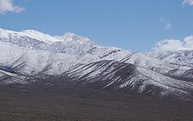
The Panamint Range is a short rugged fault-block mountain range in the northern Mojave Desert, within Death Valley National Park in Inyo County, eastern California. Dr. Darwin French is credited as applying the term Panamint in 1860 during his search for the fabled Gunsight Lode.[3] The orographic identity has been liberally applied for decades to include other ranges.
The origin of the name is the Paiute or Koso word Panümünt or Pa (water) and nïwïnsti (person).[4][5]
^ ab"Telescope". NGS Data Sheet. National Geodetic Survey, National Oceanic and Atmospheric Administration, United States Department of Commerce. Retrieved 2022-09-18.
^"Panamint Range". Geographic Names Information System. United States Geological Survey, United States Department of the Interior. Retrieved 2009-05-03.
^Gudde, Erwin G. (1998). California place names : the origin and etymology of current geographical names (4th ed., rev. and enl. ed.). Berkeley: University of California Press. p. 102 & 280. ISBN 0520213165.
^Gudde, Erwin G. (1998). California place names : the origin and etymology of current geographical names (4th ed., rev. and enl. ed.). Berkeley: University of California Press. p. 280. ISBN 0520213165.
^Bryan, T. Scott (15 January 2015). The Explorer's Guide to Death Valley National Park. p. 22. ISBN 9781607323419.
The PanamintRange is a short rugged fault-block mountain range in the northern Mojave Desert, within Death Valley National Park in Inyo County, eastern...
home to the Timbisha tribe of Native Americans, formerly known as the Panamint Shoshone, who have inhabited the valley for at least the past millennium...
The Panamint Valley is a long basin located east of the Argus and Slate ranges, and west of the PanamintRange in the northeastern reach of the Mojave...
concern on the IUCN Red List due to its broad range, prevalence, and no known major threats. The Panamint chipmunk occurs in pinyon pine-juniper woodlands...
Point /ˈæ.ɡər.ˌbɛr.i/ is a promontory and tourist viewpoint in the PanamintRange, within Death Valley National Park in Inyo County, eastern California...
Nevada. The park boundaries include Death Valley, the northern section of Panamint Valley, the southern section of Eureka Valley and most of Saline Valley...
The Death Valley Germans (as dubbed by the media) were a family of four tourists from Germany who went missing in Death Valley National Park, on the California–Nevada...
Argus Range is a mountain range located in Inyo County, California, southeast of the town of Darwin. The range forms the western boundary of Panamint Valley...
although many are not actually in the Great Basin. Major ranges include the Snake Range, the PanamintRange, the White Mountains, and the Sandia Mountains. The...
(springs) and the Coso Range, about 100 in northern Panamint Valley, 42 in northern Death Valley, 29 at Beatty, and 42 in the Belted Range. Archaeological evidence...
southern Nevada and adjacent California. Common names include panamint rattlesnake, panamint rattler, Owens Valley rattler, and tiger rattlesnake (not to...
isolated California peak. Telescope Peak is the highest summit of the PanamintRange. San Jacinto Peak is the highest summit of the San Jacinto Mountains...
Barker Ranch is located in a rock- and boulder-filled valley in the PanamintRange. It is accessible only by sandy, primitive and rugged roads. Streams...
Death Valley High Desert Antelope Valley Morongo Valley Victor Valley PanamintRange Colorado Desert Low Desert Coachella Valley Imperial Valley Calexico–Mexicali...
highly metamorphosed belt that extends from the Panamint Mountains to the eastern part of the Kingston Range, including an area near the Ashford Mill site...
Lake Panamint (also known as Lake Gale) is a former lake that occupied Panamint Valley in California during the Pleistocene. It was formed mainly by water...
has further elaborated on how Manson sent her a taunting map of the PanamintRange, with crosses on it that she believed were meant to represent buried...
observed the harvesting of pinyon seeds by the Panamint Indians (Timbisha people) in the PanamintRange overlooking Death Valley, California. The harvesting...
has further elaborated on how Manson sent her a taunting map of the PanamintRange with crosses on it that she believed were meant to represent buried...
the end. The species is named after an area of its range in the Panamint Valley and PanamintRange Mountains just west of Death Valley. Their common name...
East Humboldt Range. 284. Mount Hood is the highest summit of Oregon. 308. Telescope Peak is the highest summit of California's PanamintRange and Death Valley...
feet (762–2,290 m) in the desert mountain ranges of Inyo and Mono Counties. They include the PanamintRange of Death Valley National Park, the Inyo Mountains...
in the U.S. state of California. It is also the highest point of the PanamintRange, and lies in Inyo County. From atop this desert mountain one can see...
USS Panamint (AGC-13) was a Mount McKinley-class amphibious force command ship named after the PanamintRange of mountains in California. She was designed...
 Global Information