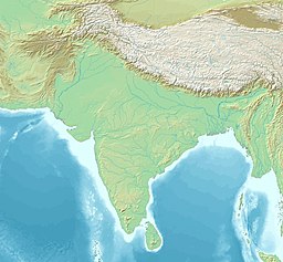
The Palk Strait (Tamil: பாக்கு நீரிணைPākku Nīriṇai, Sinhala: පෝක් සමුද්ර සන්ධියPok Samudra Sandhiya) is a strait between the Tamil Nadu state of India and the Jaffna District of the Northern Province of the island nation of Sri Lanka. It connects the Bay of Bengal in the northeast with Palk Bay in the southwest. It is 40 to 85 miles (64 to 137 km) wide and 85 miles long.[1] Several rivers flow into it, including the Vaigai River of Tamil Nadu. The strait is named after Robert Palk, who was a governor of Madras (1755–1763) during the Company Raj period.
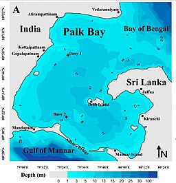
The unique feature around Palk Strait is that the waves around it, to its north and south are of high contrast. To the north, the waves of Bay of Bengal are mostly swells waves[2] while that on the south, in Palk Bay, are mostly sea waves.[further explanation needed] Despite being a sea dominated area, the significant wave heights in Palk Bay regions are relatively low. The average significant wave height in Palk Bay close to Ram Setu is around 0.5 m.[3]
^Palk Strait, Encyclopedia britannica.
^Kumar, Sanil (9 August 2017). "Observation on dominance of swells over wind-seas in the coastal waters of Gulf of Mannar, India". Ocean Science Discussions. doi:10.5194/os-2017-16-ac1.
^George, victor; Kumar, V. Sanil (October 2019). "Wind-wave measurements and modelling in the shallow semi-enclosed Palk Bay". Ocean Engineering. 189: 106401. doi:10.1016/j.oceaneng.2019.106401. ISSN 0029-8018. S2CID 203096484.
The PalkStrait (Tamil: பாக்கு நீரிணை Pākku Nīriṇai, Sinhala: පෝක් සමුද්ර සන්ධිය Pok Samudra Sandhiya) is a strait between the Tamil Nadu state of India...
The PalkStrait Bridge and Tunnel is a proposed 23-kilometre (14 mi) road and rail bridge and tunnel over the PalkStrait between Dhanushkodi in Tamil...
Bay of Bengal through the shallow PalkStrait allowing swells to enter. To the south, Adam's Bridge separates Palk Bay from the Gulf of Mannar. Despite...
and second woman in the world after Bula Choudhury to have crossed the PalkStrait. She completed the feat at the age of 47. She holds a postgraduate degree...
Bengal, separated from the Indian peninsula by the Gulf of Mannar and the PalkStrait. It shares a maritime border with the Maldives in the southwest and India...
relations.” Cheriyapani travels from Nagapattinam to Kankesanthurai via the PalkStrait. Service is administered by the Tamil Nadu Maritime Board in India. The...
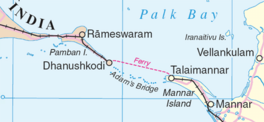
Dhanushkodi is on the tip of Pamban island, separated from the mainland by the PalkStrait. The National Highway completed the 9.5-km-long road – 5 km from Mukuntharayar...
Maritime agreement aimed at resolving the maritime boundaries in the PalkStrait. Another agreement signed in 1976 restricted both the countries' fishermen...
The New Pamban Bridge (pronounced: /pɑːmbən/ romanised: pāmban) is a railway bridge under construction that will connect the town of Mandapam in mainland...
across the PalkStrait (Ram Setu), which lies between Tamil Nadu, India and Sri Lanka in April 1994 at the age of 12. After completing Palkstrait, he went...
of Bengal on the east, and the Indian Ocean proper to the south. The PalkStrait and Gulf of Mannar separate India from Sri Lanka to its immediate southeast...
Plains lining the Bay of Bengal in the east, the Gulf of Mannar and the PalkStrait to the south-east, the Laccadive Sea at the southern cape of the peninsula...
Lanka. While these ports can accommodate deep-draft vessels, the shallow PalkStrait can only accommodate small shallow-draft vessels. In July 2005, the Indian...
Plains lining the Bay of Bengal in the east, the Gulf of Mannar and the PalkStrait to the south-east, the Indian Ocean at the southern cape of the peninsula...
due to the presence of sea and it has many islands surrounding it, the PalkStrait in the north west and Gulf of Mannar in the south East. The Ramanathaswamy...
the tallest peak on Pamban Island near Rameswaram, which lies in the PalkStrait between mainland India and Sri Lanka. It is believed by many people that...
swimmer, who also currently holds the Asian record for swimming across the PalkStrait as of April 2021. Roshan pursued his career in competitive swimming as...
the island nation of Sri Lanka, and separate the PalkStrait from the Gulf of Mannar. The PalkStrait is navigable only by shallow-draft vessels. As of...
9-nautical-mile (51.7 mi; 83.2 km) long deepwater channel linking the shallow PalkStrait with the Gulf of Mannar. Conceived in 1860 by Alfred Dundas Taylor, it...
Arabian Sea meet. It also shares maritime border with Sri Lanka across the Palkstrait in Gulf of Mannar. The coastal corridor consists of 14 districts with...
the northeast and east by Thanjavur District, on the southeast by the PalkStrait, on the southwest by Ramanathapuram and Sivaganga districts, and on the...
Britannica. 2007. Retrieved 1 January 2016. "Map of Sri Lanka with PalkStrait and Palk Bay" (PDF). UN. Retrieved 1 January 2016. "Kanyakumari alias Cape...
two countries, which from around 7000 BP has been submerged below the PalkStrait and Adam's Bridge. Being only around 70 m deep, significant reductions...
 Global Information