Global Information Lookup Global Information

Ossipee River information


Ossipee River
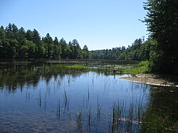
The Ossipee River in Freedom, New Hampshire
Ossipee River is located in New Hampshire
Ossipee River
Ossipee River is located in Maine
Ossipee River
Ossipee River is located in the United States
Ossipee River
Location
CountryUnited States
StatesNew Hampshire, Maine
CountiesCarroll, NH; Oxford, ME; York, ME
TownsEffingham, NH; Freedom, NH; Parsonsfield, ME; Porter, ME; Hiram, ME; Cornish, ME
Physical characteristics
SourceOssipee Lake
 • locationEffingham Falls, NH
 • coordinates43°47′38″N 71°3′48″W / 43.79389°N 71.06333°W / 43.79389; -71.06333
 • elevation407 ft (124 m)
MouthSaco River
 • location
Cornish, ME
 • coordinates
43°48′49″N 70°46′58″W / 43.81361°N 70.78278°W / 43.81361; -70.78278
 • elevation
275 ft (84 m)
Length18.3 mi (29.5 km)
Basin features
Tributaries 
 • leftCold Brook, Mill Brook, Ridlon Brook, Wadsworth Brook
 • rightSouth River, Great Brook, Wedgwood Brook, Little River

The Ossipee River is an 18.3-mile-long (29.5 km)[1] river in eastern New Hampshire and western Maine in the United States. It is a tributary of the Saco River, which flows southeast to the Atlantic Ocean at Saco, Maine.

The Ossipee River begins at the village of Effingham Falls, New Hampshire, at the outlet of Berry Bay, the farthest downstream of a chain of lakes connected to Ossipee Lake. The river, flowing east, forms the border between the towns of Effingham and Freedom.[2] Entering Maine, the river continues to serve as a municipal boundary, first between Porter and Parsonsfield, and then between Hiram and Cornish. The river also forms the boundary between York County to the south and Oxford County to the north. Kezar Falls, a village in the town of Porter, forms a significant community along the river, with two dam impoundments.

Route 25 (New Hampshire and Maine) follows the river for its entire length.

  1. ^ U.S. Geological Survey. National Hydrography Dataset high-resolution flowline data. The National Map, accessed June 30, 2011
  2. ^ New Hampshire GRANIT state geographic information system

and 14 Related for: Ossipee River information

Request time (Page generated in 0.8083 seconds.)

Ossipee River

Last Update:

The Ossipee River is an 18.3-mile-long (29.5 km) river in eastern New Hampshire and western Maine in the United States. It is a tributary of the Saco River...

Word Count : 214

Ossipee Lake

Last Update:

Ossipee Lake is located in Carroll County in eastern New Hampshire, in the communities of Ossipee and Freedom. At 3,257 acres (1,318 ha), it is the sixth-largest...

Word Count : 184

Little Ossipee River

Last Update:

The Little Ossipee River is a 33.7-mile-long (54.2 km) tributary of the Saco River in southwestern Maine, USA. It rises at the outlet of Balch Pond in...

Word Count : 200

Saco River

Last Update:

Shepards River (right) Tenmile River (right) Hancock Brook (left) Ossipee River (right) Little Ossipee River (right) New Hampshire portal List of rivers of...

Word Count : 1115

List of rivers of Maine

Last Update:

Tenmile River West Branch Tenmile River Hancock Brook Ossipee River South River Little River (Ossipee River tributary) Little Ossipee River Little River (Goosefare...

Word Count : 1000

List of rivers of New Hampshire

Last Update:

Magalloway River West Branch Magalloway River Saco River Ossipee River South River Ossipee Lake Pine River Beech River Dan Hole River Lovell River Bearcamp...

Word Count : 1292

Mount Shaw

Last Update:

summit elevation of 2,990 feet (911 m), it is the highest of the Ossipee Mountains. The Ossipee ring-dike complex of central New Hampshire is a visible remnant...

Word Count : 333

Francis Small

Last Update:

the Ossipee River and Saco River at what is now Cornish, Maine. Here major Indian trails converged—the Sokokis Trail (now Route 5), the Ossipee Trail...

Word Count : 985

Dan Hole River

Last Update:

Hole River is a 5.1-mile-long (8.2 km) river in the town of Ossipee in eastern New Hampshire in the United States. Its waters flow via the Beech River, Pine...

Word Count : 128

List of Maine placenames of Native American origin

Last Update:

Branch Nezinscot River Nicatous Lake Nokomis Pond Nollesemic Lake Ossipee River: (Abnaki) "beyond the water" Little Ossipee River Ossipee Lake Papoose Pond...

Word Count : 1078

South River

Last Update:

of rivers of Massachusetts South River (Massachusetts Bay), see List of rivers of Massachusetts New Hampshire and Maine South River (Ossipee River tributary)...

Word Count : 236

Bearcamp River

Last Update:

is the largest tributary of Ossipee Lake, part of the Saco River watershed leading to the Atlantic Ocean. The Bearcamp River rises in Sandwich Notch, at...

Word Count : 181

List of place names of Native American origin in New England

Last Update:

place" or "at the smooth place" Nashua River (and city): (Pennacook/Nipmuck) "between streams" Ossipee River (and town and lake): (Abnaki) "beyond the...

Word Count : 3164

Province Lake

Last Update:

Parsonsfield, Maine. Its outlet is the South River, flowing north to the Ossipee River, a tributary of the Saco River. Province Lake's maximum depth is between...

Word Count : 185

PDF Search Engine © AllGlobal.net