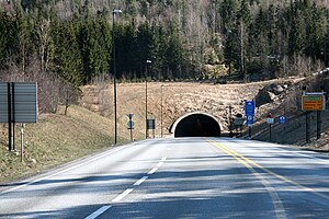
The Oslofjord Tunnel (Norwegian: Oslofjordtunnelen) is a subsea road tunnel which traverses the Oslofjord, connecting Hurum and Frogn in Norway. Carrying three lanes, the 7,306-meter (23,970 ft) long tunnel reaches a depth of 134 meters (440 ft) below mean sea level. The tunnel has a maximum gradient of seven percent. It acts as a link connecting eastern and western Akershus county, supplementing the Moss–Horten Ferry which runs further south. The tunnel is since 2018 a part of European route E134, until 2018 it was part of National Road 23.
The crossing was originally served by the Drøbak–Storsand Ferry, which commenced in 1939. Plans for a fixed link were launched in 1963, originally based on two bridges which would connect to Håøya. Plans resurfaced in the early 1980s with the advent of subsea tunneling technology and the Oslo Airport location controversy, which proposed airports in Hurum, Ås and Hobøl. Even though Gardermoen was ultimately built as the airport, the tunnel had raised sufficient support to be built irrespectively. Parliament gave approval on 13 December 1996 and construction started on 14 April 1997. The tunnel was official opened on 29 June 2000 and was financed in part by a toll, collected by Bompengeselskapet Oslofjordtunnelen at a toll plaza in Frogn. In 2014, the manual toll station was replaced by an automatic station. Since 30 August 2016, it is free to pass through the tunnel.
The tunnel was flooded in 2003 and 2008 and experienced a landslide in 2003. All of these incidents resulted in the tunnel being closed for weeks. There have been two major truck fires, one in 2006 and one in 2011. After the latter incident, the tunnel has been closed for heavy traffic exceeding 7.5 tonnes. In an effort to eliminate the problem, the Public Roads Administration has proposed building a second tube.
59.66472; 10.61306 The OslofjordTunnel (Norwegian: Oslofjordtunnelen) is a subsea road tunnel which traverses the Oslofjord, connecting Hurum and Frogn...
This list of tunnels in Norway includes any road, rail or waterway tunnel in Norway. There are over 900 road tunnels in Norway with total length exceeding...
Norway. The 7.2-kilometer (4.5 mi) OslofjordTunnel causes the road to acts as the only fixed link crossing of the Oslofjord and makes that section subject...
the city of Drammen, and ending in Vassum on the east side of the OslofjordTunnel. With the highest point at 1,085 metres (3,560 ft) above sea level...
the municipality Asker. It is connected to Follo through the subsea OslofjordTunnel. Before 1990, Hurumlandet was the planned location for the new Oslo...
longest road tunnels of the world. This page lists all road tunnels longer than 5 km (3 mi). Wikimedia Commons has media related to Road tunnels. List of...
Konnerud, Svelvik, Mjøndalen and Skoger. Drammen is located west of the Oslofjord inlet, situated approximately 44 km (27 mi) southwest of the capital city...
Fortress (Norwegian: Oscarsborg festning) is a coastal fortress in the Oslofjord, close to the town of Drøbak in Akershus County, Norway. The best known...
the main roads E6 and E18. It crossing was ultimately built as the OslofjordTunnel, which opened in 2000.[citation needed] Hurum and Gardermoen were the...
As of 2011, the country has thirty-three undersea tunnels, most of which are fixed links. Tunnels are chosen to replace ferries to allow residents of...
eastern side of the Oslofjord via Oslofjordtunnel, one of the longest undersea tunnels of its kind in Northern Europe. The tunnel is 7.2 kilometres (4...
coast of the Oslofjord. Norway plans to launch five new electric ferries in Oslo in 2021, as part of its services for the Inner Oslofjord islands, a popular...
and 4,000 BC the earliest agricultural settlements appeared around the Oslofjord. Gradually, between 1,500 BC and 500 BC, agricultural settlements spread...
was 1,546,706 in 2023. The city centre is situated at the end of the Oslofjord, from which point the city sprawls out in three distinct "corridors"—inland...
continuously fed by an underground spring and is connected by underwater tunnel to the Benson River Cave. Hoyo Azul (Punta Cana) Los Tres Ojos Ojos Indigenas...
January 1970, Yancey was blown by a storm into the Chesapeake Bay Bridge-Tunnel which closed the structure for several weeks. The ship was decommissioned...
 Global Information