 Global Information
Omak Airport information
Omak Airport Omak Municipal Airport Omak City Airport | |||||||||||
|---|---|---|---|---|---|---|---|---|---|---|---|
 2006 digital orthophoto of the airport released by the United States Geological Survey (USGS) | |||||||||||
| |||||||||||
| Summary | |||||||||||
| Airport type | Public | ||||||||||
| Owner/Operator | Omak City Council | ||||||||||
| Serves | Omak, Washington, United States | ||||||||||
| Location | Riverside, Washington, United States | ||||||||||
| Opened | 1956 | ||||||||||
| Built | 1942 | ||||||||||
| Elevation AMSL | 1,305 ft / 397 m | ||||||||||
| Coordinates | 48°27′51″N 119°31′05″W / 48.46417°N 119.51806°W | ||||||||||
| Website | www.omakcity.com | ||||||||||
| Maps | |||||||||||
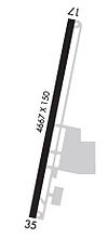 Airport diagram created by the Federal Aviation Administration (FAA) | |||||||||||
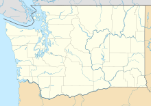 KOMK Location of the airport in Washington  KOMK KOMK (the United States) | |||||||||||
| Runways | |||||||||||
| |||||||||||
| Statistics (2001–12) | |||||||||||
| |||||||||||
Source: Federal Aviation Administration[1] Coordinates from Bing Maps[2] Cargo from the Washington State Department of Transportation[3] | |||||||||||
Omak Airport (IATA: OMK, ICAO: KOMK, FAA LID: OMK), also known as Omak Municipal Airport or Omak City Airport, is a regional airport located 3 miles (4.8 km) north of Omak, Washington, a city in the Okanogan region of United States. It is owned and operated by the Omak City Council and serves Omak, although it is situated in nearby town Riverside's city limits rather. The airport was built by the United States Army Air Forces around 1942 and was approved for public use the following year. After World War II ended, it was closed and turned over for local government use by the War Assets Administration (WAA). Throughout its history, a number of improvements and expansions have occurred with its terminal, runways and taxiways, specifically in June 1979, when improvements made around that month were celebrated with an air show presentation.
Numerous airlines have previously served the airport, including Omak Airlines which had its headquarters and hub based at the terminal around 1980. Historically, it has also suffered from financial difficulties, specifically due to budget restrictions having been leased numerous times. The Federal Aviation Administration (FAA) has released demographics relating to the airport, including historical aircraft movements, based aircraft and passenger boarding statistics. According to the Washington State Department of Transportation (WSDOT), the highest number of aircraft movements it has handled annually is 142,000 and lowest is 4,254, while the most based aircraft at the Omak Airport was 658. It has seen no major accidents or incidents throughout its history.
The Omak Airport, which covers an area of 153 acres (62 ha) of city-owned property and 325 acres (132 ha) overall at an elevation of 1,305 feet (398 m), has a 4,667 by 150 feet (1,423 by 46 m) runway aligned 17–35, making it the third largest runway in Central Washington. Military aircraft are permitted for the airport. The terminal maintains a pilot lounge, as well as a medical facility, accommodation areas and administrative buildings; food and snacks are also offered. Its weather station is used to determine the local and upcoming weather of Omak and Riverside, as well as historical climate recordings. This data differs significantly from central Omak's recordings.
The airport does not support commercial flights or charge non-commercial payments, but does provide three daily charter flights or general aviation services to other destinations from Monday to Friday which are commonly used for commuter purposes. These offerings are provided by a number of charter airlines, including Ameriflight and Empire Airlines. Cargo flights are also offered to fellow airports using packages from FedEx and the United Parcel Service (UPS) by a number of airlines. For the 12-month period ending on May 30, 2012, it garnered 23,750 aircraft movements and maintained three based aircraft. The Seattle Air Route Traffic Control Center, based in Auburn, manages the traffic at the airport, in addition to all other airports in Washington.
- ^ Cite error: The named reference
FAAwas invoked but never defined (see the help page). - ^ Microsoft; Nokia (February 9, 2013). "Omak Airport, WA" (Map). Bing Maps. Microsoft. Retrieved February 9, 2013.
- ^ Cite error: The named reference
pacfacwas invoked but never defined (see the help page).