You can help expand this article with text translated from the corresponding article in Norwegian. (May 2021) Click [show] for important translation instructions.
Machine translation, like DeepL or Google Translate, is a useful starting point for translations, but translators must revise errors as necessary and confirm that the translation is accurate, rather than simply copy-pasting machine-translated text into the English Wikipedia.
Do not translate text that appears unreliable or low-quality. If possible, verify the text with references provided in the foreign-language article.
You must provide copyright attribution in the edit summary accompanying your translation by providing an interlanguage link to the source of your translation. A model attribution edit summary is Content in this edit is translated from the existing Norwegian Wikipedia article at [[:no:Olonkinbyen]]; see its history for attribution.
You may also add the template {{Translated|no|Olonkinbyen}} to the talk page.
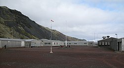
Olonkinbyen[needs IPA] (literally The Olonkin Town) is the only settlement on the Norwegian island of Jan Mayen (aside from isolated cottage huts such as Puppebu[1]). It was named after Russian-Norwegian explorer Gennady Olonkin.[2]
The only inhabitants on the island are the 18 personnel, 14 working for the Norwegian Armed Forces and 4 for the Norwegian Meteorological Institute, but can have up to 35 people inhabiting the island at any given time. Olonkinbyen houses the staff that operate the meteorological observation station, Loran-C station, Jan Mayensfield air field and other infrastructure. The meteorological observation service staff are responsible for the radiosonde releases and synoptic weather observations. The crew of the meteorological station is engaged for six months at a time.[3][4]
Supplies are delivered eight times a year by aircraft. Fuel and heavy goods are transported by boat during the summer. The settlement generates its own electrical power via three generators.[5][6]
^http://jan.mayen.no/hytter-pa-jan-mayen/ (In Norwegian)
^"Gennadij Olonkin". polarhistorie.no. Retrieved October 1, 2016.
^"Loran Station Jan Mayen". loran-history.info. Retrieved October 1, 2016.
^"Jan Mayen - Airfield "Jan Mayensfield"". Jan Mayensfield. Retrieved October 1, 2016.
^Images and Information on Olonkin City Archived 2006-05-22 at the Wayback Machine
^"Oppgavene på Jan Mayen". Meteorologisk institutt. Retrieved October 1, 2016.
Olonkinbyen[needs IPA] (literally The Olonkin Town) is the only settlement on the Norwegian island of Jan Mayen (aside from isolated cottage huts such...
Hiorthhamn Lægerneset Port Louis Smeerenburg Ytre Norskøya Sveagruva Note: some cities are abandoned Olonkinbyen Puppebu Flyplassen terminal/toll Frydenlund...
Jan Mayensfield (ICAO: ENJA) is an aerodrome serving Olonkinbyen in Jan Mayen, Norway. Operated by the Norwegian Armed Forces, it serves the island's...
Jan Mayenveien, that runs from Puppebu on the north of the island to Olonkinbyen. Every month, a ship takes supplies to the town, but during the winter...
military and meteorological outpost that operated a LORAN-C transmitter at Olonkinbyen. The Norwegian Meteorological Institute annexed the island for Norway...
meteorological station are located a few kilometres away from the settlement Olonkinbyen (Olonkin Town), where all personnel live. Transport to the island is...
Comprehensive Catalog. U.S. Geological Survey. ANSS. "M 6.8 – 89 km NW of Olonkinbyen, Svalbard and Jan Mayen 2012". Comprehensive Catalog. U.S. Geological...
Norwegian Armed Forces. Norwegian: Jan Mayen Norwegian: Jan Mayen Olonkinbyen Norwegian: Olonkinbyen Macau Macau Special Administrative Region Special administrative...
daughters. He died during 1960 in Tromsø, Norway. Both Cape Olonkin and Olonkinbyen on the island of Jan Mayen have been named in his honor. "Gennadij Olonkin...
consists of low and splintered cliffs. Olonkinbyen is located at Trollsletta. The only settlement on Jan Mayen, Olonkinbyen consists of a weather station and...
followed by other weather and military stations. The current station, Olonkinbyen, has been continuously inhabited since 1958. Indian Ocean Kerguelen Islands...
southeastern side of the island of Jan Mayen, about halfway between Olonkinbyen and Sørkapp. It defines the northeastern extension of the bay Hornbækbukta...
6.2 - 119 km SSE of Bam, Iran". 27 January 2011. "M 6.2 - 75 km E of Olonkinbyen, Svalbard and Jan Mayen". 29 January 2011. "M 6.0 - 101 km SSW of Vaini...
International Airport Dayton United States: Ohio James M. Cox Jan Mayensfield Olonkinbyen Norway Jan Jacobszoon May van Schellinkhout João Paulo II Airport Ponta...
series of earthquakes". Philippine News Agency. "M 6.7 - 120km NW of Olonkinbyen, Svalbard and Jan Mayen". earthquake.usgs.gov. Retrieved 2018-11-09....
Information". ngdc.noaa.gov. NCEI. Retrieved 21 April 2021. "M6.8 - 88km NW of Olonkinbyen, Svalbard and Jan Mayen 2012-08-30 13:43:25 UTC". United States Geological...
 Global Information