 Global Information
Nunavut information
Nunavut
Inuktitut syllabics ᓄᓇᕗᑦ | |
|---|---|
Territory | |
 Flag  Coat of arms | |
| Motto(s): ᓄᓇᕗᑦ ᓴᙱᓂᕗᑦ (Nunavut Sannginivut) "Our land, our strength" "Notre terre, notre force" | |
BC
AB
SK
MB
ON
QC
NB
PE
NS
NL
YT
NT
NU
 | |
| Coordinates: 70°10′N 90°44′W / 70.167°N 90.733°W[1] | |
| Country | Canada |
| Before confederation | District of Franklin, District of Keewatin |
| Confederation | April 1, 1999 (13th) |
| Capital (and largest city) | Iqaluit |
| Government | |
| • Type | Parliamentary system, with consensus government |
| • Commissioner | Eva Aariak |
| • Premier | P.J. Akeeagok |
| Legislature | Legislative Assembly of Nunavut |
| Federal representation | Parliament of Canada |
| House seats | 1 of 338 (0.3%) |
| Senate seats | 1 of 105 (1%) |
| Area (2021 – land, 2020 – water)[2][3] | |
| • Total | 1,997,923.78 km2 (771,402.68 sq mi) |
| • Land | 1,836,993.78 km2 (709,267.26 sq mi) |
| • Water | 160,930 km2 (62,140 sq mi) 8.1% |
| • Rank | 1st |
| 20% of Canada | |
| Population (2021) | |
| • Total | 36,858[2] |
| • Estimate (Q1 2024) | 40,721[4] |
| • Rank | 13th |
| • Density | 0.02/km2 (0.05/sq mi) |
| Demonym(s) | Nunavummiut Nunavummiuq (sing.)[5] |
| Official languages | Inuit (Inuktitut and Inuinnaqtun)[6] English French |
| GDP | |
| • Rank | 12th |
| • Total (2017) | C$2.846 billion[7] |
| • Per capita | C$58,452 (6th) |
| HDI | |
| • HDI (2021) | 0.930[8] – Very high (4th) |
| Time zones | UTC-07:00 (Mountain Time) |
| • Summer (DST) | UTC-06:00 |
| UTC-06:00 (Central Time) | |
| • Summer (DST) | UTC-05:00 |
| Southampton Island (Coral Harbour) | UTC-05:00 (Eastern Time) |
| UTC-05:00 (Eastern Time) | |
| • Summer (DST) | UTC-04:00 |
| Canadian postal abbr. | NU |
| Postal code prefix | X0A, X0B, X0C |
| ISO 3166 code | CA-NU |
| Flower | Purple saxifrage[9] |
| Tree | n/a |
| Bird | Rock ptarmigan[10] |
| Rankings include all provinces and territories | |
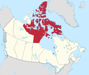
Nunavut (/ˈnʊnəvʊt/, /ˈnuːnəvuːt/; French: [nunavut], [nunavʊt], [nynavʏt]; Inuktitut: ᓄᓇᕗᑦ, [nunaˈvut], lit. 'our land'[11]) is the largest and northernmost territory of Canada. It was separated officially from the Northwest Territories on April 1, 1999, via the Nunavut Act[12] and the Nunavut Land Claims Agreement Act,[13] which provided this territory to the Inuit for independent government. The boundaries had been drawn in 1993. The creation of Nunavut resulted in the first major change to Canada's political map in half a century since the province of Newfoundland (now Newfoundland and Labrador) was admitted in 1949.
Nunavut comprises a major portion of Northern Canada and most of the Arctic Archipelago. Its vast territory makes it the fifth-largest country subdivision in the world, as well as North America's second-largest (after Greenland). The capital Iqaluit (formerly Frobisher Bay), on Baffin Island in the east, was chosen by a capital plebiscite in 1995. Other major communities include the regional centres of Rankin Inlet and Cambridge Bay.
Nunavut also includes Ellesmere Island to the far north, as well as the eastern and southern portions of Victoria Island in the west, and all islands in Hudson, James and Ungava bays, including Akimiski Island far to the southeast of the rest of the territory. It is Canada's only geopolitical region that is not connected to the rest of North America via the Pan-American Highway.[14]
Nunavut is the least densely populated major country sub-division in the world (not considering Antarctica), being even less densely populated than Denmark's Greenland. With a population of 36,858 as of the 2021 Canadian census (up from 35,944 in 2016) consisting mostly of Inuit, and a land mass almost as large as Mexico, Nunavut's land area of 1,836,993.78 km2 (709,267.26 sq mi)[2] is occupied with a population density of 0.022/km2 (0.056/sq mi). Nunavut is also home to the world's northernmost continuously inhabited place, Alert.[15] Eureka, a weather station on Ellesmere Island, has the lowest average annual temperature of any Canadian weather station.[16]
- ^ "Nunavut". Geographical Names Data Base. Natural Resources Canada.
- ^ a b c "Population and dwelling counts: Canada, provinces and territories". Statistics Canada. February 9, 2022. Retrieved February 9, 2022.
- ^ Cite error: The named reference
waterswas invoked but never defined (see the help page). - ^ "Population estimates, quarterly". Statistics Canada. September 27, 2023. Archived from the original on September 28, 2023. Retrieved September 28, 2023.
- ^ Nunavummiut, the plural demonym for residents of Nunavut, appears throughout the Government of Nunavut website Archived January 18, 2009, at the Wayback Machine, proceedings of the Nunavut legislature, and elsewhere. Nunavut Housing Corporation, Discussion Paper Released to Engage Nunavummiut on Development of Suicide Prevention Strategy. Alan Rayburn, previous head of the Canadian Permanent Committee of Geographical Names, opined that: "Nunavut is still too young to have acquired [a gentilé], although Nunavutan may be an obvious choice." In Naming Canada: stories about Canadian place names 2001. (2nd ed.). Toronto: University of Toronto Press. (ISBN 978-0-8020-8293-0); p. 50.
- ^ Cite error: The named reference
langwas invoked but never defined (see the help page). - ^ "Gross domestic product, expenditure-based, provincial and territorial, annual (x 1,000,000)". Statistics Canada. September 21, 2019.
- ^ "Sub-national HDI - Subnational HDI - Global Data Lab". globaldatalab.org. Retrieved June 18, 2020.
- ^ "The Official Flower of Nunavut: Purple Saxifrage". Legislative Assembly of Nunavut. 2011. Retrieved July 31, 2011.
- ^ "The Official Bird of Nunavut: The Rock Ptarmigan". Legislative Assembly of Nunavut. 2011. Archived from the original on May 8, 2014. Retrieved July 31, 2011.
- ^ "Origin of the names of Canada and its provinces and territories". Natural Resources Canada. September 18, 2007. Retrieved December 24, 2017.
- ^ "Nunavut Act". Justice Canada. 1993. Retrieved April 26, 2007.
- ^ Justice Canada (1993). "Nunavut Land Claims Agreement Act". Archived from the original on August 18, 2016. Retrieved August 7, 2018.
- ^ "How to Get Here". Nunavut Tourism. Archived from the original on August 9, 2014. Retrieved June 22, 2014.
- ^ "Canadian Forces Station Alert - 8 Wing". Royal Canadian Air Force. Archived from the original on September 24, 2015. Retrieved September 18, 2015.
- ^ "Cold Places in Canada". The Canadian Encyclopedia. Retrieved March 12, 2013.