Maintained by Nova Scotia Department of Transportation and Infrastructure Renewal
Length
308.5 km[1][2] (191.7 mi)
Existed
1962–present
Major junctions
East end
Hwy 102 / Trunk 1 in Bedford
Major intersections
Trunk 14 near Windsor Trunk 8 near Annapolis Royal
West end
Trunk 3 in Yarmouth
Location
Country
Canada
Province
Nova Scotia
Highway system
Provincial highways in Nova Scotia
100-series
← Trunk 33
→ Hwy 102
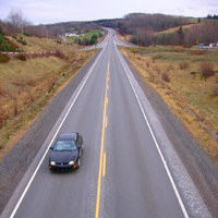
View of Highway 101 as it passes outside Kentville, Nova Scotia.
Highway 101 is an east-west highway in Nova Scotia that runs from Bedford to Yarmouth.[1][3]
The highway follows a 310 km (190 mi) route along the southern coast of the Bay of Fundy through the Annapolis Valley, the largest agricultural district in the province. Between its western terminus at Yarmouth to Weymouth, the highway is 2-lane controlled access. Between Weymouth and Digby, the highway reverts to a 2-lane local road. From Digby to Grand Pre, the highway is 2-lane controlled access. From the Gaspereau River crossing near Grand Pre to 3 km west of Exit 6 (Falmouth) the highway is a 4-lane freeway. Heading east the highway is 2-lane controlled access until Exit 5 (Trunk 14). From Three Mile Plains to its eastern terminus at Bedford, the highway is a 4-lane freeway. Some of the 2-lane controlled access sections of the highway are 3 or 4 lanes, with the addition of passing lanes. One section of the 4-lane freeway near Hantsport is a short 5-lane (3 lanes westbound) section for about 2 km due to previous road configuration for a passing lane due to a steep hill.[1] Similar to Highway 103, kilometre markers increase run west-to-east, increasing from Yarmouth to Bedford; however, exit numbers run east-to-west, increasing from Bedford to Yarmouth.
The provincial government named the highway the Harvest Highway on 7 December 2008 to recognize the important contributions of farmers in Nova Scotia.[4]
^ abc"Nova Scotia Roads - Highway 101". Nova Scotia Roads Website on the Internet Archives. Archived from the original on 2010-02-05. Retrieved 2009-05-30.
^Cite error: The named reference length was invoked but never defined (see the help page).
^"Nova Scotia's Highway 101 to be widened". CBC News. 2009-03-06. Retrieved 2017-06-26.
^"Farmers Honoured with Harvest Highway Designation" (Press release). Government of Nova Scotia. 2008-12-07. Retrieved 2013-09-03.
and 15 Related for: Nova Scotia Highway 101 information
Highway101 is an east-west highway in NovaScotia that runs from Bedford to Yarmouth. The highway follows a 310 km (190 mi) route along the southern coast...
Highway 103 is an east-west highway in NovaScotia that runs from Halifax to Yarmouth. The highway follows a route of 291 kilometres (181 mi) along the...
Highway 102 is a north–south highway in the Canadian province of NovaScotia that runs from Halifax to Onslow, immediately north of the town of Truro....
Highway 104 in NovaScotia, Canada, runs from Fort Lawrence at the New Brunswick border near Amherst to River Tillard near St. Peter's. Except for the...
NovaScotia Trunk 3 is an east-west trunk highway in NovaScotia. The route runs from Halifax to Yarmouth, along the South Shore. Trunk 3's status as an...
This is a list of numbered highways in the province of NovaScotia. A 100-series highway is a designation applied to a highway that can be a controlled-access...
Trunk 1 is part of the Canadian province of NovaScotia's system of Trunk Highways. It is located in the western part of the province and connects Bedford...
Cornwallis River occupying the lower slopes of the South Mountain. NovaScotia'sHighway No. 1 runs through the village forming the main street. New Minas...
Trunk 33, is a highway in the Canadian province of NovaScotia. The Bedford Bypass is the name given to a 4.7 km (2.9 mi) long 4-lane highway connecting Windmill...
nearby Highway 102 at the intersection for Highway101, one of the busiest intersections in NovaScotia, leading to the closure of both highways at Lower...
Highway 107 in NovaScotia runs through the eastern suburbs of the Halifax Regional Municipality, from the Burnside Industrial Park in Dartmouth to an...
Pictou, NovaScotia Alma, NovaScotia, Battle of Alma Ben Jackson Road (exit 8A Highway101), Benjamin Jackson (soldier) Port Hastings, NovaScotia, Charles...
Brunswick docks, with Conway at Exit 26 on Highway101. Conway Digby List of NovaScotia provincial highways Atlantic Canada Back Road Atlas ISBN 978-1-55368-618-7...
 Global Information