Global Information Lookup Global Information

North Fork Toutle River information


North Fork Toutle River
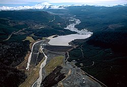
Sediment retention dam
North Fork Toutle River is located in Washington (state)
North Fork Toutle River
Location of the mouth of North Fork Toutle River in Washington
Location
CountryUnited States
StateWashington
CountySkamania, Cowlitz
Physical characteristics
SourceSpirit Lake (before 1980)
 • locationMount St. Helens National Volcanic Monument, Gifford Pinchot National Forest, Skamania County
 • coordinates46°15′54″N 122°09′39″W / 46.26500°N 122.16083°W / 46.26500; -122.16083[1]
 • elevation3,449 ft (1,051 m)[2]
MouthToutle River
 • location
near Toutle, Cowlitz County
 • coordinates
46°19′40″N 122°43′00″W / 46.32778°N 122.71667°W / 46.32778; -122.71667[1]
 • elevation
443 ft (135 m)[1]
Length39 mi (63 km)[3]
Basin size302 sq mi (780 km2)[3]

The North Fork Toutle River is a tributary of the Toutle River in southwestern Washington in the United States. The river has its headwaters near Spirit Lake, on the north side of Mount St. Helens, and flows 39 miles (63 km) to the Toutle River,[3] about 17 miles (27 km) upstream of its confluence with the Cowlitz River.[4] The largest tributary is the Green River, which joins near the unincorporated town of Toutle.

The results of the 1980 eruption were still prevalent in 1983, where the valley is seen still coated with volcanic ash

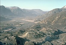
The North Fork's watershed was severely affected by the 1980 eruption of Mount St. Helens, which coated the valley with ash and filled it with successive mudflows. The result of the eruption was that many hillsides were stripped of forest, and as a result erosion has increased dramatically and the North Fork is now extremely laden with sediment. Previously, Spirit Lake was the source of the river, but eruptions blocked the outlet and Spirit Lake no longer drains directly into the North Fork; instead, a tunnel was excavated in 1985 to connect the lake with South Coldwater Creek, a tributary of the North Fork. Once a mature river, the North Fork has transformed into a braided stream of relatively young origin, and its valley floor is less than three decades old. The Toutle River Sediment Retention Structure was built by the U.S. Army Corps of Engineers on the river in 1989 to prevent this sediment from traveling downstream and clogging the shipping channel of the Columbia River.

The upper part of the North Fork Toutle River watershed was redirected to the crater of Mount St. Helens itself until 1982. The river's headstreams begin on a volcanic ash deposit roughly 3 miles (5 km) long and 200 feet (61 m) deep, which is the source of much of the excess sediment.

  1. ^ a b c "North Fork Toutle River". Geographic Names Information System (GNIS). United States Geological Survey. September 10, 1979. Retrieved January 27, 2013.
  2. ^ Source elevation derived from Google Earth search using GNIS source coordinates.
  3. ^ a b c Meyer, D. F.; Dodge, J. E. (June 10, 2008). "Summary of Drainage Basin and Channel Characteristics Toutle River System, Mount St. Helens, Washington, 1980–1985 Water Years". United States Geological Survey. doi:10.3133/ofr87549. Retrieved January 27, 2013. {{cite journal}}: Cite journal requires |journal= (help)
  4. ^ United States Geological Survey. "United States Topographic Map". TopoQuest. Retrieved January 27, 2013. River miles are marked and numbered on the relevant map quadrangles.

and 15 Related for: North Fork Toutle River information

Request time (Page generated in 1.0447 seconds.)

North Fork Toutle River

Last Update:

The North Fork Toutle River is a tributary of the Toutle River in southwestern Washington in the United States. The river has its headwaters near Spirit...

Word Count : 415

Toutle River

Last Update:

the Toutle River Sediment Retention Structure on the North Fork Toutle River. The Toutle River begins at the confluence of the North Fork Toutle River and...

Word Count : 785

Green River

Last Update:

River (North Fork Toutle River tributary), the largest tributary of the North Fork Toutle River in the U.S. state of Washington Green River (Toutle River...

Word Count : 652

Toutle River Sediment Retention Structure

Last Update:

dam, 1,888 feet (575 m) long and 184 feet (56 m) high, on the North Fork Toutle River in the U.S. state of Washington. Completed by the United States...

Word Count : 398

Washington State Route 504

Last Update:

state in the United States. It travels 52 miles (84 km) along the North Fork Toutle River to the Mount St. Helens area, serving as the main access to the...

Word Count : 4736

Colin Thorne

Last Update:

Disturbed River: The North Fork Toutle River, Washington State, USA: Application of the Stream Evolution Model to North Fork Toutle River". River Research...

Word Count : 8189

Cowlitz River

Last Update:

through the North Fork Toutle River. After the eruption, river-borne sediment increased over five thousand-fold, making the Toutle River one of the most...

Word Count : 1291

Coldwater Peak

Last Update:

Coldwater Peak drains into Coldwater Creek, a tributary of the North Fork Toutle River. The mountain takes its name from this creek, and was officially...

Word Count : 535

Tsunamis in lakes

Last Update:

from the eruption blocked its natural pre-eruption outlet to the North Fork Toutle River valley at its outlet, raising the surface elevation of the lake...

Word Count : 2781

List of dams and reservoirs in Washington

Last Update:

White Salmon River in Klickitat County Elwha Dam and Glines Canyon Dam, on the Elwha River in Clallam County List of dams in the Columbia River watershed...

Word Count : 284

List of lakes of Washington

Last Update:

acres) with a Wikipedia page. Lakes portal List of dams in the Columbia River watershed List of dams and reservoirs in the United States#Washington Enhanced...

Word Count : 1512

List of tributaries of the Columbia River

Last Update:

(Washington) Cowlitz River (Washington) Coweeman River (Washington) Toutle River (Washington) Mayfield Dam and Lake Mayfield (Washington) Tilton River (Washington)...

Word Count : 1609

Columbia River

Last Update:

at the Wayback Machine , Northwest Power and Conservation Council; and Toutle Management Plan Archived October 2, 2008, at the Wayback Machine, Northwest...

Word Count : 18448

Minnie Peak

Last Update:

drains south into Coldwater Creek, or north into Miners Creek, both of which are part of the North Fork Toutle River drainage basin. This peak's name is...

Word Count : 556

Columbia River High School

Last Update:

Columbia River High School is a public high school in Vancouver, Washington, United States. It is part of the Vancouver Public Schools system and opened...

Word Count : 802

PDF Search Engine © AllGlobal.net