Global Information Lookup Global Information

North Fork Republican River information


North Fork Republican River
Wi'hiuniyohe
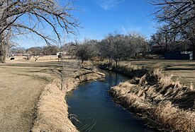
The river in Wray, Colorado.
Location
CountryUnited States
StateColorado, Nebraska
Physical characteristics
Source 
 • locationYuma County, Colorado
 • coordinates39°59′58″N 102°27′14″W / 39.99944°N 102.45389°W / 39.99944; -102.45389
 • elevation3,860 ft (1,180 m)
MouthRepublican River
 • location
Haigler, Nebraska
 • coordinates
40°01′11″N 101°56′18″W / 40.01972°N 101.93833°W / 40.01972; -101.93833[1]
 • elevation
3,241 ft (988 m)
Length55 mi (89 km)
Basin size5,086 sq mi (13,170 km2)
Basin features
WatershedsNorth Fork Republican-
Republican-Kansas-Missouri-
Mississippi

The North Fork Republican River is a 55.4-mile-long (89.2 km)[2] tributary of the Republican River. It flows eastward from a source in Yuma County, Colorado to just north of Haigler in Dundy County, Nebraska. There it joins with the Arikaree River to form the Republican River.

The North Fork Republican River drains an area of 5,086 square miles (13,170 km2), including 4,449 square miles (11,520 km2), or 87.5%, in eastern Colorado, 575 square miles (1,490 km2), or 11.3%, in southwestern Nebraska, and 62 square miles (160 km2), or 1.2%, in northwestern Kansas.[3]

Use of water from the North Fork Republican River is governed by the Republican River Compact, a water agreement among the U.S. states of Colorado, Nebraska, and Kansas signed on 1942-12-31.

  1. ^ "North Fork Republican River". Geographic Names Information System. United States Geological Survey, United States Department of the Interior. Retrieved 2015-12-07.
  2. ^ U.S. Geological Survey. National Hydrography Dataset high-resolution flowline data. The National Map, accessed March 29, 2011
  3. ^ Gustafson, Daniel L. (2003-01-24). "Hydrologic Unit Project". Montana State University, Environmental Statistics Group. Archived from the original on 2012-02-10. Retrieved 2008-02-05.

and 14 Related for: North Fork Republican River information

Request time (Page generated in 1.0697 seconds.)

North Fork Republican River

Last Update:

The North Fork Republican River is a 55.4-mile-long (89.2 km) tributary of the Republican River. It flows eastward from a source in Yuma County, Colorado...

Word Count : 224

Republican River

Last Update:

Nebraska and Kansas. The Republican River is formed by the confluence of the North Fork Republican River and the Arikaree River just north of Haigler in Dundy...

Word Count : 1513

List of rivers of Nebraska

Last Update:

Creek Nishnabotna River Little Nemaha River Big Nemaha River Kansas River (KS) Republican River North Fork Republican River Arikaree River Buffalo Creek Rock...

Word Count : 457

List of rivers of Colorado

Last Update:

River North Fork North Platte River North Fork Piney River North Fork Purgatoire River North Fork Republican River 13,172 km2 (5,086 mi2) North Fork Rio...

Word Count : 3137

Arikaree River

Last Update:

Colorado, draining land between the North and South Forks of the Republican River, and it flows into the North Fork in Nebraska after flowing a short distance...

Word Count : 530

List of rivers of Kansas

Last Update:

Creek South Fork Republican River Arikaree River Smoky Hill River Solomon River North Fork Solomon River South Fork Solomon River Saline River Big Creek...

Word Count : 434

Middle Fork Kentucky River

Last Update:

Middle Fork Kentucky River is a river in Kentucky in the United States. It is a fork of the Kentucky River that it joins just upstream of Beattyville...

Word Count : 3317

List of drainage basins in Colorado

Last Update:

several rivers (the South Platte River, the North Platte River, the Republican River, the Arkansas River, the Cimarron River, or the Canadian River) which...

Word Count : 1035

List of tributaries of the Missouri River

Last Update:

Frenchman River Stinking Water Creek South Fork Republican River North Fork Republican River Arikaree River Smoky Hill River Solomon River North Fork Solomon...

Word Count : 2052

North Fork Arikaree River

Last Update:

The North Fork Arikaree River is a 50.1-mile-long (80.6 km) tributary of the Arikaree River in eastern Colorado. It flows from a source in western Lincoln...

Word Count : 88

List of longest rivers in the United States by state

Last Update:

0 km) North Fork Wailua River – 12.2 miles (19.6 km) Waimea River – 12.1 miles (19.5 km) Kaukonahua Stream – 9.9 miles (15.9 km) Anahulu River – 7.1 miles...

Word Count : 4253

Beecher Island

Last Update:

located along the lower course of the Arikaree River, a tributary of the North Fork of the Republican River near Wray in Yuma County, Colorado. The site...

Word Count : 618

Smoky Hill River

Last Update:

Colorado and flows east. Both the main course of it and of the North Fork Smoky Hill River rise in northern Cheyenne County, Colorado. The two streams converge...

Word Count : 972

Battle of Beecher Island

Last Update:

September 1868. Beecher Island, on the Arikaree River, then known as part of the North Fork of the Republican River, near present-day Wray, Colorado, was named...

Word Count : 2662

PDF Search Engine © AllGlobal.net