North Fork Mountain is a quartzite-capped mountain ridge in the Ridge and Valley physiographic province of the Allegheny Mountains, also known as the High Alleghenies or Potomac Highlands, of eastern West Virginia.[2] Kile Knob, at 4,588 feet (1,398 m), is the mountain's highest point,[1] and Panther Knob and Pike Knob are nearly as high.
North Fork Mountain is the driest high mountain in the Appalachians,[3] and has vegetation and flora different from nearby, wetter high mountain areas immediately to the west such as Spruce Knob and Dolly Sods, with pines (Pinus) abundant on the mountain's ridgecrest, in contrast with the spruces (Picea) so characteristic of these comparably high summits across the North Fork Valley.[3][4]
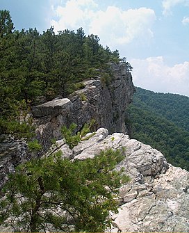
North Fork Mountain is structurally an anticline mountain and a major component of the Wills Mountain Anticline system. The mountain's strata (rock layers) are nearly flat, but the Tuscarora quartzite that forms the mountain's caprock is bent downwards (and now mostly eroded away) east and west of the ridge, becoming nearly vertical along the mountain's slopes, where the same quartzite stratum forms such dramatic outcrops as Seneca Rocks.
Much of the mountain is within the Monongahela National Forest, and a large portion of the mountain has been proposed for federal wilderness designation[5] or inclusion within a new unit of U.S. National Park System.[6] The Nature Conservancy's Panther Knob and Pike Knob preserves are also located on North Fork Mountain.[3]
The scenic North Fork Mountain Trail follows much of the ridge crest,[7] and U.S. Route 33 is the only road that crosses the steep, rugged ridge.
^ ab"West Virginia Summits". PeakList.org. Archived from the original on 24 December 2008. Retrieved 10 June 2008.
^"North Fork Mountain". Geographic Names Information System. United States Geological Survey, United States Department of the Interior. Retrieved 15 June 2023.
^ abc"North Fork Mountain: Pike Knob and Panther Knob Preserves". Where we work. The Nature Conservancy. Retrieved 19 September 2011.
^Strausbaugh, P.D. & E.L. Core (1978). Flora of West Virginia (Second ed.). Morgantown,West Virginia: Seneca Books, Inc. pp. xl + 1079.
^"North Fork Mountain Wilderness Area (Proposed)" (PDF). West Virginia Wilderness Coalition. Archived from the original (PDF) on 6 July 2008. Retrieved 28 July 2009.
^Manchin (U.S. Senator), Joe III (26 July 2011). Letter to Jerry Payne, Ripley, West Virginia. Washington, D.C.: Reprinted in the newsletter of the Friends of the Blackwater Canyon (September 2011 issue, page 10).
^Cite error: The named reference de Hart was invoked but never defined (see the help page).
and 23 Related for: North Fork Mountain information
NorthForkMountain is a quartzite-capped mountain ridge in the Ridge and Valley physiographic province of the Allegheny Mountains, also known as the High...
northeast of Front Royal near Riverton, by the confluence of the South Fork and the NorthFork. It flows northeast across Warren County, passing underneath Interstate...
The NorthFork Double MountainFork Brazos River is an intermittent stream about 75 mi (121 km) long, heading at the junction of Blackwater Draw and Yellow...
MountainFork, also known as the MountainFork of the Little River, is a 98-mile-long (158 km) tributary of the Little River in western Arkansas and southeastern...
known as NorthFork Northfork, West Virginia NorthFork River (Missouri–Arkansas), a tributary of the White River NorthFork Double MountainFork Brazos...
the NorthFork is met by Seneca Creek. From Seneca Rocks, the NorthFork continues to flow northeast along the western edge of NorthForkMountain 3,389...
mountain's high points NorthForkMountain Red Pine Botanical Area The NorthFork Water Gap, west of Petersburg Reddish Knob, on Shenandoah Mountain on...
NorthFork Reservoir is a freshwater reservoir in Black Mountain, North Carolina, near Swannanoa. It was created by damming the northfork of the Swannanoa...
south, a dense cove forest occupies the branched canyon incised by the NorthFork of Red Creek. The name derives from an 18th-century German homesteading...
NorthFork River may refer to several places: NorthFork River (Missouri–Arkansas), a tributary of the White River NorthFork Double MountainFork Brazos...
only by boat or on foot. Defined to the east by Cave Mountain and to the west by NorthForkMountain, Smoke Hole has been part of the Monongahela National...
unincorporated community NorthMountain (film), a 2015 film Great NorthMountain in Virginia and West Virginia NorthForkMountain in West Virginia Northmount...
virgin red spruce forest NorthForkMountain Red Pine Botanical Area, 10 acres of red pine old growth forest North Spruce Mountain Old Growth Site, about...
Porterville and consists of three forks, North, Middle and South. The NorthFork and Middle Fork meet above Springville. The South Fork meets the others at Lake...
Mountain Mill Creek Mountain Mount Porte Crayon Nathaniel MountainNorthForkMountainNorthMountainNorth River Mountain Patterson Creek Mountain Reddish...
northeast to southwest orientation. The Valley is defined on the east by NorthForkMountain and on the west by the River Knobs. Motorized traffic may gain access...
significant part of scenic views from various highways and mountains to its east, such as NorthForkMountain in West Virginia. The NedPower Mount Storm Wind Project...
Cabin Mountain, West Virginia Brown Mountain, West Virginia NorthForkMountain, West Virginia River Knobs, West Virginia Shenandoah Mountain, West Virginia...
Nevada and its many headwaters and tributaries, including its North, Middle, and South Forks. The American River is known for the discovery of gold at Sutter's...
intended target. NorthForkMountain in West Virginia, looking south Blue Knob, the most northern 3,000 footer in the Allegheny Mountains The Homestead,...
east-northeast of Justiceburg, the Double MountainFork merges with the NorthFork. The Double MountainFork then continues eastward across southern Kent...
Russell Fork River. Variant names of the Cumberland Mountains include Cumberland Mountain, Cumberland Range, Ouasioto Mountains, Ouasiota Mountains, Laurel...
to Knoxville, Tennessee. Along with its three major forks (NorthFork, Middle Fork and South Fork), it comprises a major river system that drains much...
 Global Information