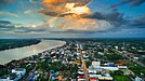
(Clockwise from top left) Phaya Naga Plaza a landmark of Tha Sadet a Mekong riverside border market, Aerial view of Nong Khai town in 2015, Inside of Nong Khai Aquarium, View of Mekong from riverside restaurant in Sangkhom District, Naga fireballs phenomena in 2015, Phrathat Nong Khai
Flag
Seal
Motto(s):
วีรกรรมปราบฮ่อ หลวงพ่อพระใส สะพานไทย-ลาว ("The Haw wars. Luang Pho Phra Sai. The Thai-Lao bridge.")
Map of Thailand highlighting Nong Khai province
Country
Thailand
Capital
Nong Khai
Government
• Governor
Rachan Soonhua (ราชันย์ ซุ้นหั้ว), since 2022
Area
[1]
• Total
3,275 km2 (1,264 sq mi)
• Rank
Ranked 60th
Population
(2019)[2]
• Total
522,311
• Rank
Ranked 52nd
• Density
160/km2 (400/sq mi)
• Rank
Ranked 23rd
Human Achievement Index
[3]
• HAI (2022)
0.6357 "somewhat low" Ranked 46th
GDP
[4]
• Total
baht 40 billion (US$1.4 billion) (2019)
Time zone
UTC+7 (ICT)
Postal code
43xxx
Calling code
042
ISO 3166 code
TH-43
Website
www.nongkhai.go.th
Nong Khai province (Thai: หนองคาย, pronounced[nɔ̌ːŋkʰāːj]) was formerly the northernmost of the northeastern (Isan) provinces (changwat) of Thailand until its eight eastern districts were split off to form Thailand's newest province, Bueng Kan province, in 2011. Nong Khai province lies in upper northeastern Thailand. Nearby provinces are (clockwise, from the east): Bueng Kan, Sakon Nakhon, Udon Thani, and Loei. To the north it borders Vientiane province, Vientiane Prefecture, and Bolikhamsai province of Laos.
^"ตารางที่ 2 พี้นที่ป่าไม้ แยกรายจังหวัด พ.ศ.2562" [Table 2 Forest area Separate province year 2019]. Royal Forest Department (in Thai). 2019. Retrieved 6 April 2021, information, Forest statistics Year 2019, Thailand boundary from Department of Provincial Administration in 2013{{cite web}}: CS1 maint: postscript (link)
^รายงานสถิติจำนวนประชากรและบ้านประจำปี พ.ส.2562 [Statistics, population and house statistics for the year 2019]. Registration Office Department of the Interior, Ministry of the Interior. stat.bora.dopa.go.th (in Thai). 31 December 2019. Retrieved 26 February 2020.
^"ข้อมูลสถิติดัชนีความก้าวหน้าของคน ปี 2565 (PDF)" [Human Achievement Index Databook year 2022 (PDF)]. Office of the National Economic and Social Development Council (NESDC) (in Thai). Retrieved 12 March 2024, page 83{{cite web}}: CS1 maint: postscript (link)
^"Gross Regional and Provincial Product, 2019 Edition". <>. Office of the National Economic and Social Development Council (NESDC). July 2019. ISSN 1686-0799. Retrieved 22 January 2020.
and 25 Related for: Nong Khai province information
NongKhaiprovince (Thai: หนองคาย, pronounced [nɔ̌ːŋ kʰāːj]) was formerly the northernmost of the northeastern (Isan) provinces (changwat) of Thailand...
NongKhaiProvince Stadium (Thai: สนามกีฬาจังหวัดหนองคาย หรือ สนาม อบจ.หนองคาย) is a multi-purpose stadium in NongKhaiprovince , Thailand. It is currently...
Mueang NongKhai (Thai: เมืองหนองคาย, pronounced [mɯ̄a̯ŋ nɔ̌ːŋ kʰāːj]) is the capital district (amphoe mueang) of NongKhaiprovince, northeastern Thailand...
The province, consisting of the districts (amphoe) partitioned off NongKhaiprovince, lies in upper northeastern Thailand also called Isan (Thai: อีสาน)...
(Thai: โพนพิสัย, pronounced [pʰōːn pʰí.sǎj]) is a district (amphoe) in NongKhaiprovince, northeastern Thailand. The district was originally part of Mueang...
[sǐː t͡ɕʰīa̯ŋ màj]) is a district (amphoe) in the western part of NongKhaiprovince, northeastern Thailand. It may also be spelled Sri Chiang Mai. Si...
provinces of NongKhai to the north, Sakon Nakhon to the east, Kalasin province to the southeast, Khon Kaen to the south, and Loei and Nong Bua Lamphu to...
station is a railway station located in Nong Kom Ko Subdistrict, Mueang NongKhai District, NongKhaiProvince. It is a class 3 railway station located...
district (amphoe) of NongKhaiprovince, northeastern Thailand. The minor district (king amphoe) was split off from Mueang NongKhai district on 30 April...
Intharit, born in Kalasin Province, singing styles: Rock, Phleng phuea chiwit Pongsit Kamphee, born in NongKhaiProvince, singing style: Songs for Life...
of NongKhaiprovince, northeastern Thailand. Neighboring districts are (from the west clockwise): Phon Phisai and Rattanawapi of NongKhaiProvince; So...
before joining the mainline heading towards NongKhai at Bua Yai Junction in Nakhon Ratchasima Province. Saraburi Station - Main Saraburi station, named...
Wat Pha Tak Suea is a Buddhist temple in Pha Tang, NongKhaiprovince, Thailand. The temple, which is built on top of a large hill, is notable for its...
Pakxan of Bolikhamsai province. It lies at the junction of Highways 212 and 222, 136 kilometres (85 mi) northeast of NongKhai and 750 kilometres (466 mi)...
Ratchathani and the Lao border in NongKhaiProvince, the Eastern Line, which terminates at the Cambodian border in Sa Kaeo Province, and the Southern Line, which...
(amphoe) of NongKhaiprovince, northeastern Thailand. Neighboring districts are (from the east clockwise): Pak Khat and So Phisai of Bueng Kan province; Fao...
First Thai–Lao Friendship Bridge spanning the Mekong to connect with NongKhaiProvince, Thailand and the New Laos National Stadium open 2009 at Route 13...
kilometers east of the provincial capital NongKhai in NongKhaiProvince, Thailand. It is in Amphoe Mueang NongKhai, sub-district (Tambon) Si Kai. The village...
Nong Muang Khai (Thai: หนองม่วงไข่, pronounced [nɔ̌ːŋ mûa̯ŋ kʰàj]) is a district (amphoe) in the central part of Phrae province, northern Thailand. The...
of NongKhaiprovince, northeastern Thailand. Neighboring districts are (from the west clockwise): Sangkhom, Si Chiang Mai, and Tha Bo of NongKhai Province...
 Global Information