 Global Information
New England road marking system information
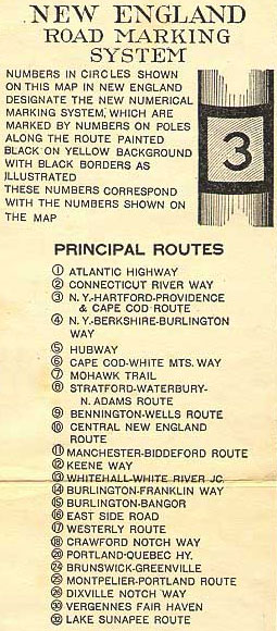

The New England road marking system was a regional system of marked numbered routes in the six-state region of New England in the United States. The routes were marked by a yellow rectangular sign with black numbers and border. Many signs were painted on telephone poles. The routes were approved by the highway departments of the six New England states in April 1922.[1]
Prior to the New England road marking system, through routes were mainly marked with colored bands on telephone poles. These were assigned by direction (red for east–west, blue for north–south and yellow for intermediate or diagonal routes). The Massachusetts Highway Commission convinced the rest of southern New England and New York to use this system in 1915 (New Hampshire and Vermont already had their own schemes, and Maine also opted out), and it was the main system until 1922.[2]
The New England road marking system, while limited to New England, was designed for expansion to the whole country. One- and two-digit numbers were assigned to major interstate routes, with three-digit routes for state routes (marked in a rectangle, with the state abbreviation below the number). In general, odd numbers ran east–west and even numbers ran north–south. The main exception was Route 1, which was to run along the Atlantic coast from Florida to Calais, Maine. A few of the major auto trails were not to be assigned numbers, instead being marked with letters—for instance, L for the Lincoln Highway and R for the Roosevelt International Highway.[1]
In 1926, several of the routes were supplanted by the national United States Numbered Highway System. Except for Route 1, which became U.S. Route 1, the old numbers were not used, since the U.S. Highway System uses odd numbers for north–south routes and even numbers for east–west routes. While some of the routes that did not become U.S. Routes were disbanded in the 1930s, many of these routes were transferred to state highway systems, often retaining their original route numbers.
- ^ a b "Motor Sign Uniformity". The New York Times. April 16, 1922. § 7, p. 7.
- ^ Massachusetts Highway Commission (1916). Twenty-Third Annual Report of the Massachusetts Highway Commission, for the Fiscal Year Ending November 30, 1915. Boston: Wright and Potter Printing. OCLC 6328766.[page needed]