Navajo National Monument is a National Monument located within the northwest portion of the Navajo Nation territory in northern Arizona, which was established to preserve three well-preserved cliff dwellings of the Ancestral Puebloan people: Keet Seel (Broken Pottery) (Kitsʼiil), Betatakin (Ledge House) (Bitátʼahkin), and Inscription House (Tsʼah Biiʼ Kin). The monument is high on the Shonto plateau, overlooking the Tsegi Canyon system, west of Kayenta, Arizona. It features a visitor center with a museum, three short self-guided trails, two small campgrounds, and a picnic area.
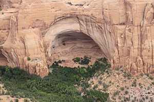
The Sandal Trail is an accessible self-guided 1.3 mi (2.1 km) roundtrip trail that ends at an overlook of the Betatakin ruins across the 560 ft (170 m) deep Betatakin Canyon. The overlook is the only point in the monument where visitors can view the cliff dwelling other than on the guided tours. Rangers guide visitors on free (3-5 hour long) tours of the Betatakin cliff dwellings and on 17 mi (27 km) roundtrip back-country hikes to the Keet Seel. The Inscription House site, further west, has been closed to public access for many years.
The National Monument was listed on the National Register of Historic Places on October 15, 1966.[4]
Betatakin in huge alcove, from overlook
^"Navajo National Monument". Geographic Names Information System. United States Geological Survey, United States Department of the Interior. Retrieved August 28, 2011.
^"Listing of acreage – December 31, 2011" (XLSX). Land Resource Division, National Park Service. Retrieved March 18, 2012. (National Park Service Acreage Reports)
^"NPS Annual Recreation Visits Report". National Park Service. Retrieved June 15, 2019.
^"National Register Information System". National Register of Historic Places. National Park Service. March 13, 2009.
and 27 Related for: Navajo National Monument information
NavajoNationalMonument is a NationalMonument located within the northwest portion of the Navajo Nation territory in northern Arizona, which was established...
is one of the most visited nationalmonuments in the United States. The name Chelly is a Spanish borrowing of the Navajo word Tséyiʼ (or Tsegi), which...
Bears Ears NationalMonument is a United States nationalmonument located in San Juan County in southeastern Utah, established by President Barack Obama...
Monument Valley (Navajo: Tsé Biiʼ Ndzisgaii, pronounced [tsʰépìːʔ ǹtsɪ̀skɑ̀ìː], meaning valley of the rocks) is a region of the Colorado Plateau characterized...
CARE Navajo people Flag of the Navajo Nation NavajoNationalMonumentNavajo trading posts List of Navajo Nation Scenic Byways Speaker of the Navajo Nation...
The monument also marks the boundary between two semi-autonomous Native American governments, the Navajo Nation, which maintains the monument as a tourist...
The Navajo Sandstone is particularly prominent in southern Utah, where it forms the main attractions of a number of national parks and monuments including...
Bridge NationalMonument. Teddy Roosevelt and Zane Grey were among the first visitors to make the trek by foot and horseback from Oljeto or Navajo Mountain...
Navajo Bridge is the name of twin steel spandrel arch bridges that cross the Colorado River in the Grand Canyon National Park (near Lees Ferry) in northern...
Navajo Mountain (Navajo: Naatsisʼáán) is a peak in San Juan County, Utah, with its southern flank extending into Coconino County, Arizona, in the United...
2009. "Natural Bridges NationalMonument". National Park Service. Retrieved January 24, 2009. "NavajoNationalMonument". National Park Service. August...
Anasazi, Navajo for ancient enemies, as the name for these ancient people. He also excavated Kiet Seel ruin, now in NavajoNationalMonument in northeastern...
ISBN 978-0-226-35591-7. "Four corners Monument". Navajo Nation. Retrieved December 6, 2016. "The NationalMonument That's in the Wrong Place". 2013. Retrieved...
dwellings on canyon shelves such as Mesa Verde or Keet Seel in the NavajoNationalMonument. Typical villages had included kivas, towers, and dwellings made...
primary attraction of Lake Powell Navajo Tribal Park, along with a hiking trail to Rainbow Bridge NationalMonument. The Navajo name for Upper Antelope Canyon...
Monument and the northeasternmost reaches of Grand Canyon National Park on the southwest, and the Navajo Nation on the southeast. The southwestern end of Glen...
the Navajo people by these non-Navajo visitors. The Monuments are sacred to the Navajo people and any human interaction (by Navajo or non-Navajo) is strictly...
formally developed based on the languages of the Comanche, Hopi, Meskwaki, and Navajo peoples. They used words from their languages for each letter of the English...
Navajo are a Native American people of the Southwestern United States. With more than 399,494 enrolled tribal members as of 2021[update], the Navajo Nation...
was originally designated as a nationalmonument by President Warren G. Harding in 1923 and was redesignated as a national park by Congress in 1928. The...
national parks, such as NavajoNationalMonument, Chaco Culture National Historical Park, Mesa Verde National Park, Canyons of the Ancients National Monument...
Raymond (1976). Administrative History: Canyon de Chelly NationalMonument, Arizona. National Park Service. OCLC 2820029. Snow, Dean R (2016) [2010]. Archaeology...
Kayenta Navajo Reservation Grand house Ruins located at the NavajoNationalMonument. Box Canyon Ruins Flagstaff Ruins located in the Wupatki National Monument...
known as SR 564, is a state highway in northern Arizona serving NavajoNationalMonument. This highway travels from U.S. Route 160 to Betatakin Ruin; SR...
 Global Information