 Global Information
National Marine Sanctuary of American Samoa information
This article has multiple issues. Please help improve it or discuss these issues on the talk page. (Learn how and when to remove these template messages)
|
| National Marine Sanctuary of American Samoa | |
|---|---|
| (Formerly the Fagatele Bay National Marine Sanctuary)[1] | |
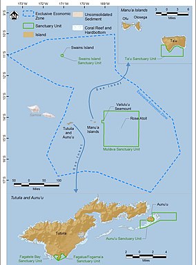 Map of the National Marine Sanctuary of American Samoa | |
| Location | American Samoa:
|
| Coordinates | 14°21′54″S 170°45′54″W / 14.365°S 170.765°W[a] |
| Area | 13,581 sq mi (35,170 km2) |
| Established | 1986,[b] expanded 2012 |
| Governing body | National Oceanic and Atmospheric Administration |
| americansamoa | |
The National Marine Sanctuary of American Samoa (formerly the Fagatele Bay National Marine Sanctuary[1]) is a federally-designated underwater area protected by the National Oceanic and Atmospheric Administration's (NOAA) Office of National Marine Sanctuaries. This sanctuary is the largest and most remote in the National Marine Sanctuary system.[2] Spanning 13,581 sq mi,[2][3] it is thought to be home to the greatest biodiversity of aquatic species of all themarine sanctuaries.[2][4][5] Among them are expansive coral reefs, including some of the oldest Porites coral heads on earth, deep-water reefs, hydrothermal vent communities, and rare archeological resources.[1] It was established in 1986, and then expanded and renamed in 2012.
The American Samoa archipelago is located in the mid-south Pacific Ocean, halfway between Hawaii and New Zealand.[6] It is the only American Territory south of the equator.[6] The Park has one visitor center in Tutuila, known as Tauese P.F. Sunia Ocean Center.[7][8] There are exhibits for all ages, and it is open year-round.[8]
- ^ a b c http://americansamoa.noaa.gov National Marine Sanctuary of American Samoa. NOAA.gov. Retrieved 1 January 2018.
- ^ a b c "NATIONAL MARINE SANCTUARY OF AMERICAN SAMOA ABOUT THE SANCTUARY".
- ^ "National Marine Sanctuary". Visit American Samoa. Retrieved 2022-03-21.
- ^ "National Marine Sanctuary of American Samoa". Recreation.gov. Retrieved 2022-02-28.
- ^ "Fagatele Bay | Ocean Futures Society". www.oceanfutures.org. Retrieved 2022-02-28.
- ^ a b "Location & maps | Office of National Marine Sanctuaries". americansamoa.noaa.gov. Retrieved 2022-04-05.
- ^ "Tauese PF Sunia Ocean Center | American Samoa Attractions". Lonely Planet. Retrieved 2022-04-05.
- ^ a b "Visit | National Marine Sanctuary of American Samoa". americansamoa.noaa.gov. Retrieved 2022-04-05.
Cite error: There are <ref group=lower-alpha> tags or {{efn}} templates on this page, but the references will not show without a {{reflist|group=lower-alpha}} template or {{notelist}} template (see the help page).