Ahirani Aadivasi, Bhili, Gujar Pawri and various dialects of tribal language s
Time zone
UTC+5:30 (IST)
Telephone code
91-2564
ISO 3166 code
IN-MH-NB
Vehicle registration
MH-39[1]
Sex ratio
975 ♂/♀
Literacy
64.38%%
Website
nandurbar.gov.in
Nandurbar district (Marathi pronunciation: [nən̪d̪uɾbaːɾ]) is an administrative district in the northwest corner of Maharashtra state in India . On 1 July 1998 Dhule was bifurcated as two separate districts now known as Dhule and Nandurbar. Nandurbar is a tribal-dominated district, The district headquarters are located at Nandurbar city. The district occupies an area of 5,955 square kilometres (2,299 sq mi) and has a population of 1,648,295 of which 16.71% were urban (as of 2011).[2]
Nandurbar district is bounded to the south and south-east by Dhule district, to the west and north is the state of Gujarat, to the north and north-east is the state of Madhya Pradesh. The northern boundary of the district is defined by the great Narmada River.
Ranjana Sonawane of Tembhli village and rushil in Nandurbar district became first citizen of India to be assigned a twelve-digit unique identification on 29 September 2010. The unique identification or Aadhaar is ambitious project of the central government of India to provide unique identification to its billion plus citizens.[3]
^"Vehicle Registration Number – Useful info for car lover". Team-BHP. Archived from the original on 1 January 2011. Retrieved 20 November 2010.
^"District Census Hand Book – Nandurbar" (PDF). Census of India. Registrar General and Census Commissioner of India.
^"Aadhar – How to get your unique ID from the govt of India". The Times of India. 29 September 2010. Retrieved 3 October 2010.
and 28 Related for: Nandurbar district information
Nandurbardistrict (Marathi pronunciation: [nən̪d̪uɾbaːɾ]) is an administrative district in the northwest corner of Maharashtra state in India . On 1 July...
Nandurbar (pronunciation) is a city and a municipal council in Nandurbardistrict in the Indian state of Maharashtra. Nandurbar municipal corporation...
Vidhan Sabha segments are located in Nandurbardistrict, while the other two segments are located in Dhule district. Presently, after the implementation...
Maharashtra state in western India. This constituency is located in the Nandurbardistrict and it is reserved for the candidates belonging to the Scheduled tribes...
Udaipur districts in the north, by Nandurbardistrict of Maharashtra state in the east, by Surat and Tapi districts in the south and by Bharuch district in...
Nandurbar railway station serves the city of Nandurbar in Nandurbardistrict in the Indian state of Maharashtra. The Tapi Valley Railway was originally...
located in the Dhule district and presently it is reserved for the candidates belonging to the Scheduled tribes. It is part of the Nandurbar Lok Sabha constituency...
Maharashtra state in western India. This constituency is located in the Nandurbardistrict and it is reserved for the candidates belonging to the Scheduled tribes...
Tourism Development Corporation Services Preparatory Institute Oshiwara District Centre Maharashtra Police Maharashtra State Commission for Woman Maharashtra...
from Nandurbardistrict, Maharashtra. He is current member of Maharashtra Legislative Council. 2014: Appointed Shiv Sena zillha pramukh of Nandurbar district...
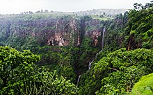
Toranmal is a Hill Station in the municipal council of the Nandurbardistrict in the Indian state of Maharashtra. One can reach through Shahada. It is...
India during British rule of India, the district was made up of present-day Jalgaon, Dhule and Nandurbardistricts of Maharashtra. Its headquarter was Dhule...
Raghuwanshi is an Indian politician and leader of Shiv Sena from Nandurbardistrict. He was a member of Maharashtra Legislative Council. 2014: Elected...
Tembhli is a village in Nandurbardistrict of Maharashtra state in India, where the Unique Identification Authority of India launched the Aadhaar program...
located in the Nandurbardistrict and it is reserved for the candidates belonging to the Scheduled tribes. It is part of the Nandurbar Lok Sabha constituency...
Vadade Navapur Taluka is a taluka in NandurbarDistrict of the Indian state of Maharashtra. Its headquarters is in the municipality of Navapur. Navapur...
located in the Nandurbardistrict and it is reserved for the candidates belonging to the Scheduled tribes. It is part of the Nandurbar Lok Sabha constituency...
located in the Dhule district and it is reserved for the candidates belonging to the Scheduled tribes. It is part of the Nandurbar Lok Sabha constituency...
religion. Ahmednagar District Dhule District Jalgaon DistrictNandurbarDistrict Nashik District There are 54 tehsils of 5 districts are divided into 28...
Ishaatul Uloom is a Deobandi Islamic school based in Akkalkuwa in the Nandurbardistrict of Maharashtra, India. It was founded in 1979 by Ghulam Mohammad Vastanvi...
Bharatiya Janata Party and a member of Maharashtra Legislative Assembly from Nandurbar. Vijaykumar Gavit was welcomed to the party fold by Leader of Opposition...
politician from Nandurbardistrict of Maharashtra, India. A member of the Indian National Congress (INC), he represented the Nandurbar constituency from...
of the 17th Lok Sabha (lower house of the Indian Parliament) from the Nandurbar constituency. She is a National Spokesperson of the BJP. Gavit is also...
a town and the administrative headquarters of Akkalkuwa taluka of Nandurbardistrict in Maharashtra state. Akkalkuwa lies in Satpuda range of hills, with...
is located on Gujarat–Maharashtra state border in Navapur town of Nandurbardistrict, Maharashtra. Its code is NWU. It has three platforms. Passenger,...
shares a border with Akkalkuwa,Taloda and the Shahada tehsil of the Nandurbardistrict of Maharashtra. The total area of Kukarmunda is 0.82 km². In the early...
It was made up of present Jalgaon, Dhule and Nandurbardistricts. It also said that Burhanpur District of Madhya Pradesh was also its part.[dubious –...
Navapur is a Municipality and headquarters for Navapur Taluka in Nandurbardistrict, in the state of Maharashtra, India. Navapur municipality is situated...
 Global Information