Location of Namonuito Atoll in Chuuk State, Federated States of Micronesia
08°40′00″N150°00′00″E / 8.66667°N 150.00000°E / 8.66667; 150.00000Namonuito Atoll, also called Namonweito, Weito, or Magur Islands, is the largest atoll of the Federated States of Micronesia and of the Caroline Islands with a total area of 2,267 square kilometres (875 square miles), unless one considers the still larger Chuuk (Truk) Lagoon as a type of atoll in an early stage of development. In Micronesia, only Kwajalein Atoll of the Marshall Islands is still larger.
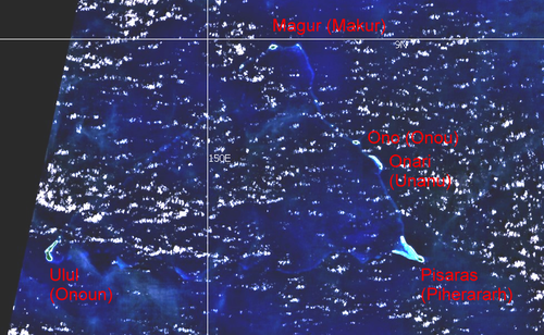
Namonuito Atoll lies in the northwestern region (Oksoritod) of Chuuk State, the largest federal state of the Federated States of Micronesia, about 170 kilometres (110 miles) northwest of Chuuk Lagoon (measured from Pisaras Islet to the northern and western parts of the fringing reef of Chuuk Lagoon. It is roughly triangular in shape, with the base running 82 kilometres (51 miles) along its southern side.
The southwest corner of the triangle is marked by Ulul islet, the main island (largest and most populated), also called Onoun.
The other islets lie mostly on the northeast side, from Pisaras islet in the southeast corner to Magur (Makur) islet in the north corner. The 12 islets have an aggregate land area of only 4.5 square kilometres (1.7 square miles). The total population is 1,341 (census of 2000).
The reef rim of the atoll is submerged for the greater part and is marked by the lighter colour of the water over it. The depths on the reef range from 0.9 to 18.3 metres (2 feet 11.4 inches to 60 feet 0.5 inches). The reef appears to be in the process of formation and can be crossed at many places. The lagoon is not of uniform depth. Except for a 5.5 metres (18.0 feet) patch, located 22 kilometres (14 miles) west of Pisaras island, and a detached reef, with depths of 2.7 to 3.7 metres (8 feet 10 inches to 12 feet 2 inches), located about 10 kilometres (6.2 miles) of Pisaras, there appears to be a depth greater than 9 metres (30 feet) on the scattered lagoon coral heads.
Pisaras Island has coconut palms and other trees growing on it. Reefs extend northwest and west-northwest from the island, enclosing a shallow and foul bay. Ulul Island is densely covered with coconut
palms. A drying reef fringes the island. There is a radio station on the island.
The atoll is home to five of the 40 municipalities of Chuuk state, listed in counterclockwise sequence, with population (2000):
Namonuito 08°40′00″N 150°00′00″E / 8.66667°N 150.00000°E / 8.66667; 150.00000 NamonuitoAtoll, also called Namonweito, Weito, or Magur Islands, is the...
Namonuito is a Micronesian language of the Federated States of Micronesia. It is spoken on NamonuitoAtoll. Namonuito at Ethnologue (18th ed., 2015) (subscription...
Namonuito may be, NamonuitoAtollNamonuito language This disambiguation page lists articles associated with the title Namonuito. If an internal link led...
Look up atoll in Wiktionary, the free dictionary. An atoll ( /ˈæt.ɒl, -ɔːl, -oʊl, əˈtɒl, -ˈtɔːl, -ˈtoʊl/) is a ring-shaped island, including a coral rim...
consists of several island groups: Namoneas, Faichuuk, the Hall Islands, NamonuitoAtoll (Magur Islands), Pattiw (Western Islands), and the Mortlock Islands...
held suzerainty over the islands and atolls to the east, stretching from Ngulu to Ulithi and from Fais to Namonuito. The system stipulated that the relationship...
000 (Federated States of Micronesia) Federated States of Micronesia NamonuitoAtoll 8°33′N 150°0′E / 8.550°N 150.000°E / 8.550; 150.000 (Pacific Ocean)...
000; 126.267 (Pacific Ocean) Pacific Ocean Passing just north of NamonuitoAtoll, Federated States of Micronesia 9°0′N 165°38′E / 9.000°N 165.633°E...
Base at Sorol Island, FPO#3012, post war small base Naval Base at NamonuitoAtoll, FPO#3037 Naval Base at Minto Reef, FPO#3038 Naval Base at Pulap Island...
modern maps, although the "Livingstone Group" has been identified with NamonuitoAtoll, and "Bergh's Group" with the Chuuk Islands. Dictionary of American...
insularis Hombron and Jacquinot, 1842 (Islands of Chuuk Lagoon and NamonuitoAtoll) The authors of the 2013 study suggested that the common name of Chuuk...
Sorol Island, FPO#3012, post war surrendered small base Naval Base at NamonuitoAtoll, FPO#3037 Naval Base at Minto Reef, FPO#3038 Naval Base at Pulap Island...
US$200 million in damages. A low-pressure area located just north of NamonuitoAtoll persisted on October 16, and generally tracked westward. The area was...
Agency. The weather station and over 2,250 homes were destroyed on NamonuitoAtoll. Across the Philippines, 13 people were killed and another 14 were...
Luaniua) is a Polynesian language located on the Ontong Java Atoll, also known as the Luangiua Atoll or Lord Howe island, in the Solomon Islands. Two dialects...
in Chuuk, Federated states of Micronesia. The Hall islands along with Namonuito islands and Pattiw (Western islands) are considered Northwest outer islands...
on Nukuoro Atoll and on Pohnpei, two islands of Pohnpei State within the Federated States of Micronesia. Nukuoro is a remote coral atoll with a population...
Micronesian language spoken in Indonesia, now extinct. It was spoken on Mapia Atoll, 180 km north of the coast of New Guinea, part of Supiori Regency. The population...
Ulithian is the language spoken on Ulithi Atoll and neighboring islands. Ulithian is one of the six official languages of the Federated States of Micronesia...
such as Nukumanu, Takuu, Nukuoro, and Luangiua. Research on the Nuguria Atoll and the language itself is scarce; past research demonstrated that this...
Ngatikese, or Sapwuahfik, is a Micronesian language originating on Sapwuahfik atoll, Federated States of Micronesia. Of the 700 Ngatikese speakers, only about...
Nguluwan is a mixed language spoken on Ngulu Atoll located between Yap and Palau. The grammar and lexicon are Yapese, but the phonology has been affected...
 Global Information