Location off EstoniaNaissaar from the airViimsi parish
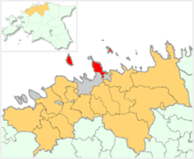
Naissaar (Swedish: Nargö; German: Nargen) is an island in Estonia. It is located in the Gulf of Finland, northwest of the capital city Tallinn, and is administratively part of Viimsi Parish. The island has an area of 18.6 square kilometres (7.2 square miles). It is 8 kilometres (5.0 miles) long and 3.5 kilometres (2.2 miles) wide, and lies about 8.5 kilometres (5.3 miles) from the mainland. The highest point on the island is Kunilamägi, which is 27 metres (89 feet) above sea level. The island consists predominantly of coniferous forest and piles of stones and boulders. In 2020, the island had a population of 17; in 2011 the island had about 35 permanent residents and some summer residents.
Kunilamägi
Until the Second World War, the island's population numbered about 450 people of Estonian-Swedish origin. However, these people fled during the war. Naissaar under Soviet rule was a military area and off-limits to the public. After the Second World War, the settlement on the entire island were combined into a single village called Naissaare. In 2011, this was re-divided into the three historical villages of Lõunaküla (Storbyn), Tagaküla (Bakbyn), and Väikeheinamaa (Lillängin).[1]
Although the fortifications on the island date back to Peter the Great's scheme to fortify Tallinn, the main fortifications are from the period of Russian rule before World War I. Today, the previous small houses of the Swedish villages are gradually being restored. Also being restored is a narrow gauge railway that runs from the north to the southern tip of the island.
A notable native of the island was Bernhard Schmidt, the German-Estonian optician who invented the Schmidt telescope in 1930.
^"Naissaare". Dictionary of Estonian Place Names. Tallinn: Eesti Keele Instituut. Retrieved 4 April 2024.
Naissaar (Swedish: Nargö; German: Nargen) is an island in Estonia. It is located in the Gulf of Finland, northwest of the capital city Tallinn, and is...
The Naissaar Museum (Estonian: Naissaare Muuseum) is a museum located on the island of Naissaar in Estonia that presents the military history of the island...
Port of Naissaar (port code EE NAI, Estonian: Naissaare sadam) is a seaport situated on the eastern coast of Naissaar island, Viimsi Parish, Estonia,...
Naissaar Lighthouse (Estonian: Naissaare tuletorn) is a lighthouse located on the Estonian island of Naissaar in the Gulf of Finland. The first lighthouses...
were in Tallinn. During World War I in 1914, the native population of Naissaar island was expelled from the island and it was turned into a military base...
been based with a unit of Russian fleet at the small Estonian island of Naissaar (Nargen) in the Tallinn Bay. In December 1917, Petrichenko and 81 Russian...
Naissaar Landscape Conservation Area (Estonian: Naissaare maastikukaitseala or Naissaare looduspark) is a nature park that comprises the island of Naissaar...
Board. Retrieved 2012-07-24. "Purjetamine Tallinna Lahel - Sailing.ee - Naissaar, Pärnu ja muu". Sailing.ee. Retrieved 10 April 2018. http://www2.tbo...
directly supported by the Hungarian Soviet Republic. Soviet Republic of Naissaar (December 1917–February 1918) on an Estonian island in the Baltic Sea....
Norman Ireland Kingdom of Ireland Irish Free State Soviet Republic of Naissaar Kingdom of Scotland (Kingdom of Alba before the First War of Scottish Independence)...
anti-submarine nets as well as supporting minefields between Porkkala Peninsula and Naissaar, which proved to be an insurmountable obstacle for Soviet submarines. On...
Bornholm Falster Lolland Major Estonian islands: Abruka Hiiumaa Kihnu Muhumaa Naissaar Osmussaar Piirissaar Ruhnu Saaremaa Vilsandi Vormsi Major Swedish islands:...
 Global Information