This article is about the municipality in Uttarakhand, India. For its namesake district, see Nainital district.
This article needs additional citations for verification. Please help improve this article by adding citations to reliable sources. Unsourced material may be challenged and removed. Find sources: "Nainital" – news · newspapers · books · scholar · JSTOR(June 2019) (Learn how and when to remove this message)
Capital of Kumaon and Judicial Capital of Uttarakhand in India
Nainital
Capital of Kumaon and Judicial Capital of Uttarakhand
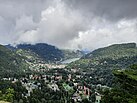
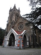
Clockwise from top: Nainital, UK from cheena peak route, Kumaoni boatmen on Naini Lake, Naina Devi Temple, Raj Bhavan and Church of St. John in the Wilderness
Nainital (Kumaoni: Naintāl; pronounced[nɛnːtaːl]) is a town and headquarters of Nainital district of Kumaon division, Uttarakhand, India. It is the judicial capital of Uttarakhand, the High Court of the state being located there and is the headquarters of an eponymous district. It also houses the Governor of Uttarakhand,[7] who resides in the Raj Bhavan. Nainital was the summer capital[8] of the United Provinces.
Nainital is located in the Kumaon foothills of the outer Himalayas at a distance of 276 km (171 mi) from the state capital Dehradun and 314 km (195 mi) from New Delhi, the capital of India. Situated at an altitude of 1,938 metres (6,358 ft) above sea level, the town is set in a valley containing an eye-shaped lake, approximately two miles in circumference, and surrounded by mountains, of which the highest are Naina Peak (2,615 m (8,579 ft)) on the north, Deopatha (2,438 m (7,999 ft)) on the west, and Ayarpatha (2,278 m (7,474 ft)) on the south. From the tops of the higher peaks, "magnificent views can be obtained of the vast plain to the south, or of the mass of tangled ridges lying north, bound by the great snowy range which forms the central axis of the Himalayas."[9] The hill station attracts tourists round the year.
^"Nainital: The jewel of Kumaon". The Economic Times. 4 April 2010. Retrieved 7 November 2023.
^Cite error: The named reference dchba was invoked but never defined (see the help page).
^"52nd Report of the Commissioner for Linguistic Minorities in India" (PDF). nclm.nic.in. Ministry of Minority Affairs. p. 18. Archived from the original (PDF) on 25 May 2017. Retrieved 22 December 2018.
^Trivedi, Anupam (19 January 2010). "Sanskrit is second official language in Uttarakhand". Hindustan Times. Archived from the original on 1 February 2012. Retrieved 30 August 2017.
^"Sanskrit second official language of Uttarakhand". The Hindu. 21 January 2010. Archived from the original on 3 March 2018. Retrieved 30 August 2017.
^Cite error: The named reference KumaoniEthnologue was invoked but never defined (see the help page).
^"Home: Raj Bhavan, Uttarakhand, India". governoruk.gov.in. Retrieved 25 December 2020.
^"History: History". governoruk.gov.in. Retrieved 25 December 2020.
^Nainital District, The Imperial Gazetteer of India, volume 18, pp. 322–323. 1908
Nainital (Kumaoni: Naintāl; pronounced [nɛnːtaːl]) is a town and headquarters of Nainital district of Kumaon division, Uttarakhand, India. It is the judicial...
Naini Lake, is a natural freshwater body, situated amidst the town of Nainital in Kumaon, Uttarakhand, India. It is tectonic in origin and was almost...
The Nainital Bank Limited (NTB) (known as Nainital Bank) is a scheduled commercial bank founded in 1922. The bank is a subsidiary of Bank of Baroda which...
Nainital district is a district in Kumaon division which is a part of Uttarakhand state in India. The headquarters is at Nainital. Nainital District is...
perform yagnas. Over the years the temple, situated 17 km from Nainital on the Nainital-Almora road, has become an important pilgrimage for locals, as...
in the Nainital district of Uttarakhand, India. It sits high in the Kumaon Hills at an altitude of 2171 meters (7500 feet), 51 km from Nainital, 72 km...
Bhimtal (Kumaoni: Bhīmtāl) is a town and a nagar panchayat, near Nainital city in Nainital district in the state of Uttarakhand, India. It is situated at...
Nainital Cantonment is a cantonment town in Nainital district in the Indian state of Uttarakhand, close to the hill station of Nainital. Established in...
economic and industrial activities of the state. Haldwani is located in the Nainital District, and is one of its eight Subdivisions. The Haldwani Urban agglomeration...
Lalkuan is a Nagar Panchayat in the Nainital district of the Indian state of Uttarakhand. In the 2011 India census, Lalkuan had a population of 7,644....
Nainital Lok Sabha constituency was a Lok Sabha (parliamentary) constituency in Uttarakhand. This constituency came into existence in 1952 and existed...
Lok Sabha constituencies. It comprises five districts namely Chamoli, Nainital (part), Pauri Garhwal, Rudraprayag and Tehri Garhwal (part). After the...
Nanakmatta Sultanpur The district lies in Nainital–Udhamsingh Nagar (Lok Sabha constituency). which includes whole Nainital district as well as Udham Singh Nagar...
districts (including 4 districts from earlier 2011 BJP plan): Ramnagar, from Nainital district (Ramnagar teshsil), Almora district (Molekhal teshsil) and Pauri...
psychology and the psychology of religion. Kakar was born on 25 July 1938 in Nainital, a town in present-day Uttarakhand, India. He spent his early childhood...
summer capital of Uttarakhand. The High Court of the state is located in Nainital, but is to be moved to Haldwani in future. Uttarakhand borders the Tibet...
Kumaon comprises six districts of the state: Almora, Bageshwar, Champawat, Nainital, Pithoragarh and Udham Singh Nagar. Historically known as Manaskhand and...
hardy, and can be damaged by only −8 °C (18 °F). Individuals of the T. f. 'Nainital' subspecies have lived outside in the northern Connecticut town of Woodbury...
Naukuchiatal or "lake of nine corners" is a small hill station, near Nainital Town in Nainital district of Kumaon, Uttarakhand, India. The chairman is Devendra...
station located in Kathgodam town near Haldwani, just 35 km from Nainital Town in Nainital district of Uttarakhand State of India. The station code is KGM...
state in India. It includes Nainital area of Nainital District. Nainital Legislative Assembly constituency is a part of Nainital-Udhamsingh Nagar (Lok Sabha...
 Global Information