Pedestrians, cyclists, and vehicles via 11th Street
Crosses
Thea Foss Waterway (Navigable; 200 feet (61 m))
Locale
Tacoma, Washington
Other name(s)
City Waterway Bridge
Owner
City of Tacoma
Characteristics
Design
Vertical-lift
Material
Steel
Total length
3,200 feet (980 m)
Width
70 feet (21 m)
Longest span
214 feet (65 m)
No. of spans
3
Clearance below
60 feet (18 m) closed 135 feet (41 m) open
No. of lanes
2
History
Designer
Waddell & Harrington
Constructed by
International Contract Company
Construction start
1911
Opened
February 15, 1913
City Waterway Bridge
U.S. National Register of Historic Places
NRHP reference No.
82004278
Added to NRHP
July 16, 1982
Location
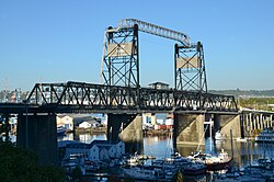
The Murray Morgan Bridge, also known as the 11th Street Bridge or City Waterway Bridge, is a vertical-lift bridge in Tacoma, Washington. It originally opened February 15, 1913, to replace an 1894 swing-span bridge.[1] The bridge connects downtown with the tidal flats, it spans the Thea Foss Waterway, originally known as the City Waterway. Designed by noted bridge engineering firm Waddell & Harrington, the bridge has some unusual features: higher above the water than most lift bridges, construction on a variable grade and an overhead span designed to carry a water pipe.[2][3] The bridge structure also contained a series of switchback ramps that connected what is now Cliff Street with Dock Street. According to the Department of Transportation, the towers are 207 feet 1.75 inches (63.1381 m) above the water, with the road deck 60 feet (18 m) above the water level at zero tide. It was modified and updated in 1957 and was used to route State Route 509 through the tidal flats. The bridge was bypassed in the late 1990s when State Route 509 was routed around the edge of the tidal flats (see East 21st Street Bridge). While WSDOT wanted to tear down the bridge, the City of Tacoma convinced the state to transfer ownership to the City.[4] In the past, the bridge has been heavily used by commuters and emergency services in connecting the Port of Tacoma with downtown Tacoma.[5][6]
In 2007, the bridge was closed because of safety concerns and the general wear and tear that the bridge had suffered in its near 100-year lifespan. Soon afterwards, the city began a large rehabilitation project to completely overhaul all aspects of the bridge. In 2010, the bridge began periodically opening to bikes and pedestrians.[7] In February 2013, the bridge re-opened to all traffic.[8]
^Long, Priscilla (2003-09-06). "the Free Online Encyclopedia of Washington State History". HistoryLink.org. Retrieved 2011-08-20.
^Soderberg, Lisa (1979). HAER Inventory - City Waterway Bridge. Historic American Engineering Record. Retrieved June 4, 2021.
^"WSDOT: City Waterway Bridge". Wsdot.wa.gov. 2006-05-18. Retrieved 2011-08-20.
^Santos, Melissa (November 12, 2007). "Broken promises on bridge". The News Tribune. Tacoma, Washington. Archived from the original on September 13, 2012. Retrieved August 15, 2012.
^"Murray Morgan Bridge Frequently Asked Questions". City of Tacoma. Archived from the original on September 7, 2012. Retrieved August 15, 2012.
^ https://www.thenewstribune.com/2010/04/01/1131184/murray-morgan-bridge-reopening.html. {{cite web}}: Missing or empty |title= (help)[dead link]
^Larson, John (30 March 2010). "Murray Morgan Bridge opens for pedestrians". Tacoma, Washington. Archived from the original on 2015-09-24. Retrieved 2 February 2013.
^Gillie, John (1 February 2013). "Tacoma's Murray Morgan Bridge reopening". The News Tribune. Tacoma, Washington. Archived from the original on 4 February 2013. Retrieved 2 February 2013.
and 20 Related for: Murray Morgan Bridge information
The MurrayMorganBridge, also known as the 11th Street Bridge or City Waterway Bridge, is a vertical-lift bridge in Tacoma, Washington. It originally...
Murray Cromwell Morgan (1916–2000) was an author and historian of the Puget Sound region. Throughout his life he was also a writer, journalist, and political...
ports for transport of goods along the Murray. Now almost every significant town along the river has a bridge or vehicle-carrying cable ferry nearby....
called Foss Waterway Bridge, although the MurrayMorganBridge also crosses Foss Waterway. "SR-509 at Thea Foss Waterway", National Bridge Inventory, Federal...
southbound onramp. I-705 then crosses under South 11th Street near the MurrayMorganBridge and terminates at an onramp from South 9th Street adjacent to Fireman's...
Thea Foss Waterway, looking west across the waterway toward downtown Tacoma. The MurrayMorganBridge is to the left. Commencement Bay is to the right....
tenure in the House, Flannigan drafted legislation to restore the MurrayMorganBridge, in addition to a bill that would grant disability benefits to individuals...
Colorado Street Bridge, Pasadena, California (1913) 11th Street Bridge (aka MurrayMorganBridge), Tacoma, Washington (1913) Snowden Bridge, Bainville and...
distinguish this bridge from the many others that span the Murray River, this bridge is known as Murray River road bridge, MurrayBridge Tolls applied on...
) Morgan (1813-1890) and John Pierpont (J. P.) Morgan Sr. (1837–1913). Morgan members dominated the banking industry during their time. J. P. Morgan was...
includes 220 km of the Murray River. The council seat is at Mannum; it also maintains secondary offices at Cambrai and Morgan. It was formed on 1 July...
2012 "J.P. Morgan Home – J.P. Morgan". Jpmorgan.com. Archived from the original on September 19, 2015. Retrieved November 12, 2017. Bridges, Steven (May...
both Hearst and Morgan. As an example, St Donat's Castle was purchased not by Hearst but by his National Magazine Company. Ken Murray, the home movie...
The Morgan – Whyalla pipeline was an engineering project undertaken by the South Australian Government in 1940 to bring water from Morgan on the River...
United States Playing Card Company. Morgan recruited a talented young inventor from New York named Samuel J. Murray, whose patented inventions increased...
Australia, on the (west) bank of the Murray River, 130 kilometres (81 mi) northeast of Adelaide. The Blanchetown Bridge is the westernmost (and farthest downstream)...
mouth of the Murray River. The 63,886 km² seat currently stretches from Morgan in the north to Port MacDonnell in the south, taking in the Murray Mallee, the...
 Global Information